


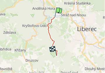

8.5 km | 12.5 km-effort
![Trail On foot Liberec - [Z] Machnín - Výpřež - Photo](https://media.geolcdn.com/t/1900/400/6c4e39a9-4192-4f95-a548-5d74e5c76113.jpeg&format=pjpeg&maxdim=2)

Tous les sentiers balisés d’Europe GUIDE+


FREE GPS app for hiking
 SityTrail
IGN / Geographical institutes
SityTrail World
The world is yours!
Trail On foot of 8.6 km to be discovered at Northeast, Liberecký kraj, Liberec. This trail is proposed by SityTrail - itinéraires balisés pédestres.
Trail created by cz:KČT.
![Trail On foot Liberec - [Z] Machnín - Výpřež - Photo 1](https://media.geolcdn.com/t/2048/auto/96723f1b-8a74-4ce7-af08-32f9931a4016.jpeg&format=jpg&maxdim=0 "Trail On foot Liberec - [Z] Machnín - Výpřež - Photo 1")
![Trail On foot Liberec - [Z] Machnín - Výpřež - Photo 2](https://media.geolcdn.com/t/2048/auto/53e94194-f12f-4c42-bd06-e8937d8f4661.jpeg&format=jpg&maxdim=0 "Trail On foot Liberec - [Z] Machnín - Výpřež - Photo 2")
![Trail On foot Liberec - [Z] Machnín - Výpřež - Photo 3](https://media.geolcdn.com/t/2048/auto/5baee1f0-09b6-4344-a4fe-c36055e6e587.jpeg&format=jpg&maxdim=0 "Trail On foot Liberec - [Z] Machnín - Výpřež - Photo 3")
![Trail On foot Liberec - [Z] Machnín - Výpřež - Photo 4](https://media.geolcdn.com/t/2048/auto/2474f8c9-09f9-488a-8807-337b92a0554a.jpeg&format=jpg&maxdim=0 "Trail On foot Liberec - [Z] Machnín - Výpřež - Photo 4")
![Trail On foot Liberec - [Z] Machnín - Výpřež - Photo 5](https://media.geolcdn.com/t/2048/auto/c43190fe-0e27-4d22-8b4f-03711d87f49e.jpeg&format=jpg&maxdim=0 "Trail On foot Liberec - [Z] Machnín - Výpřež - Photo 5")
![Trail On foot Liberec - [Z] Machnín - Výpřež - Photo 6](https://media.geolcdn.com/t/2048/auto/6340d842-99c1-4d56-accc-2626b0e1acf8.jpeg&format=jpg&maxdim=0 "Trail On foot Liberec - [Z] Machnín - Výpřež - Photo 6")
![Trail On foot Liberec - [Z] Machnín - Výpřež - Photo 7](https://media.geolcdn.com/t/2048/auto/27934c15-6904-41e5-ba55-51137560ef1e.jpeg&format=jpg&maxdim=0 "Trail On foot Liberec - [Z] Machnín - Výpřež - Photo 7")
![Trail On foot Liberec - [Z] Machnín - Výpřež - Photo 8](https://media.geolcdn.com/t/2048/auto/2a9cf556-312b-4f2d-87f6-51e8bb16def1.jpeg&format=jpg&maxdim=0 "Trail On foot Liberec - [Z] Machnín - Výpřež - Photo 8")
![Trail On foot Liberec - [Z] Machnín - Výpřež - Photo 9](https://media.geolcdn.com/t/2048/auto/08d83658-af66-4483-9a18-25c25509af46.jpeg&format=jpg&maxdim=0 "Trail On foot Liberec - [Z] Machnín - Výpřež - Photo 9")
![Trail On foot Liberec - [Z] Machnín - Výpřež - Photo 10](https://media.geolcdn.com/t/2048/auto/6c4e39a9-4192-4f95-a548-5d74e5c76113.jpeg&format=jpg&maxdim=0 "Trail On foot Liberec - [Z] Machnín - Výpřež - Photo 10")
![Trail On foot Chrastava - [Ž] Chrastava - Bedřichovský les - Photo](https://media.geolcdn.com/t/375/260/592d5d26-6f35-4f32-b996-51a61a06f566.jpeg&format=jpg&maxdim=2)
On foot
![Trail On foot Kryštofovo Údolí - [M] Výpřež - Novina - Photo](https://media.geolcdn.com/t/375/260/71803f80-2c0c-496d-ad1d-7e0e8f6a53b1.jpeg&format=jpg&maxdim=2)
On foot