![](/images/other/stat-length.png)
![Trail On foot Seifhennersdorf - LG-Gelber Strich - Zittau-Seifhennersdorf - Photo](https://media.geolcdn.com/t/1900/400/16589c7c-c152-433d-909d-1eca6ed681c2.jpeg&format=pjpeg&maxdim=2)
LG-Gelber Strich - Zittau-Seifhennersdorf
SityTrail - itinéraires balisés pédestres
Tous les sentiers balisés d’Europe GUIDE+
![Length](/images/other/stat-length.png)
Length
8.9 km
![Max alt](https://static1.geolcdn.com/siteimages/upload/files/1508320355ic_sort_altitude_max_24dp.png)
Max alt
453 m
![Uphill gradient](https://static1.geolcdn.com/siteimages/upload/files/1508320355ic_sort_den_pos_24dp.png)
Uphill gradient
186 m
![Km-Effort](/images/other/stat-length.png)
Km-Effort
11.6 km
![Min alt](https://static1.geolcdn.com/siteimages/upload/files/1508320355ic_sort_altitude_min_24dp.png)
Min alt
284 m
![Downhill gradient](https://static1.geolcdn.com/siteimages/upload/files/1508320355ic_sort_den_neg_24dp.png)
Downhill gradient
271 m
![Boucle](https://static1.geolcdn.com/siteimages/upload/files/16400158638029165_repeat_loop_refresh_sync_direction_icon.png)
Boucle
No
Signpost
Creation date :
2025-02-06 19:02:21.336
Updated on :
2025-02-06 19:02:21.336
![On foot](https://static1.geolcdn.com/sitytour/trail-icons/100.png)
2h38
Difficulty : Easy
![Scan this QR Code to open this trail in the SityTrail application](https://capi.geolives.com/qq0zvz2zws4bq2lad0pu/sitytour/trails/4343913/qr.png?size=200)
FREE GPS app for hiking
About
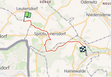
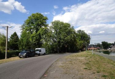
Trail On foot of 8.9 km to be discovered at Saxony, Görlitz, Seifhennersdorf. This trail is proposed by SityTrail - itinéraires balisés pédestres.
Description
Symbol: Gelber Strich auf weißem Grund
Positioning
Country:
Germany
Region :
Saxony
Department/Province :
Görlitz
Municipality :
Seifhennersdorf
Location:
Unknown
Start:(Dec)
Start:(UTM)
475206 ; 5643751 (33U) N.
Comments
Trails nearby
![Trail On foot Polevsko - NS Za polevskými obry - Photo](https://media.geolcdn.com/t/375/260/b947cb3d-a05e-4825-b7c3-ef8eb4b315f0.jpeg&format=jpg&maxdim=2)
![On foot On foot](https://static1.geolcdn.com/sitytour/trail-icons/100.png)
NS Za polevskými obry
On foot
Easy
Polevsko,
Northeast,
Liberecký kraj,
Czech Republic
![](/images/other/stat-length.png)
3.7 km | 5.1 km-effort
1h 10min
![](https://static1.geolcdn.com/siteimages/upload/files/16400158638029165_repeat_loop_refresh_sync_direction_icon.png)
No
![Trail On foot Lipová - Kirchsteig - Photo](https://media.geolcdn.com/t/375/260/a598bad9-45e8-43ba-b178-6c26761dd1d3.jpeg&format=jpg&maxdim=2)
![On foot On foot](https://static1.geolcdn.com/sitytour/trail-icons/100.png)
Kirchsteig
On foot
Easy
Lipová,
Northwest,
Ústecký kraj,
Czech Republic
![](/images/other/stat-length.png)
5.2 km | 7.1 km-effort
1h 37min
![](https://static1.geolcdn.com/siteimages/upload/files/16400158638029165_repeat_loop_refresh_sync_direction_icon.png)
No
![Trail On foot Krásná Lípa - [M] Brtnický okruh - Photo](https://media.geolcdn.com/t/375/260/2c25ed32-bc80-4d66-bfb8-31499feb073b.jpeg&format=jpg&maxdim=2)
![On foot On foot](https://static1.geolcdn.com/sitytour/trail-icons/100.png)
[M] Brtnický okruh
On foot
Easy
Krásná Lípa,
Northwest,
Ústecký kraj,
Czech Republic
![](/images/other/stat-length.png)
6.6 km | 8.5 km-effort
1h 55min
![](https://static1.geolcdn.com/siteimages/upload/files/16400158638029165_repeat_loop_refresh_sync_direction_icon.png)
Yes
![Trail On foot Šluknov - NS Šluknov - Rožany - Královka - Photo](https://media.geolcdn.com/t/375/260/b1e44d18-3351-4729-9b7f-d48e8ddfd66f.jpeg&format=jpg&maxdim=2)
![On foot On foot](https://static1.geolcdn.com/sitytour/trail-icons/100.png)
NS Šluknov - Rožany - Královka
On foot
Easy
Šluknov,
Northwest,
Ústecký kraj,
Czech Republic
![](/images/other/stat-length.png)
3.9 km | 5.3 km-effort
1h 11min
![](https://static1.geolcdn.com/siteimages/upload/files/16400158638029165_repeat_loop_refresh_sync_direction_icon.png)
Yes
![Trail On foot Dolní Podluží - Hornícká NS Údolí Milířky - Photo](https://media.geolcdn.com/t/375/260/19b06cf1-f78e-4613-a2f2-e9ab759b0997.jpeg&format=jpg&maxdim=2)
![On foot On foot](https://static1.geolcdn.com/sitytour/trail-icons/100.png)
Hornícká NS Údolí Milířky
On foot
Easy
Dolní Podluží,
Northwest,
Ústecký kraj,
Czech Republic
![](/images/other/stat-length.png)
4.7 km | 7.2 km-effort
1h 38min
![](https://static1.geolcdn.com/siteimages/upload/files/16400158638029165_repeat_loop_refresh_sync_direction_icon.png)
Yes
![Trail On foot Jetřichovice - [Z] Dolský mlýn - Pod Borovinou - Photo](https://media.geolcdn.com/t/375/260/cc7734bc-a1cb-44c1-a579-3999a7e367e8.jpeg&format=jpg&maxdim=2)
![On foot On foot](https://static1.geolcdn.com/sitytour/trail-icons/100.png)
[Z] Dolský mlýn - Pod Borovinou
On foot
Easy
Jetřichovice,
Northwest,
Ústecký kraj,
Czech Republic
![](/images/other/stat-length.png)
3.7 km | 5.3 km-effort
1h 12min
![](https://static1.geolcdn.com/siteimages/upload/files/16400158638029165_repeat_loop_refresh_sync_direction_icon.png)
No
![Trail On foot Chřibská - [M] Chřibská - Rybniště (žst) - Photo](https://media.geolcdn.com/t/375/260/ec85bc98-2fdb-4814-b82a-0c53d51cc939.jpeg&format=jpg&maxdim=2)
![On foot On foot](https://static1.geolcdn.com/sitytour/trail-icons/100.png)
[M] Chřibská - Rybniště (žst)
On foot
Easy
Chřibská,
Northwest,
Ústecký kraj,
Czech Republic
![](/images/other/stat-length.png)
3.4 km | 4.9 km-effort
1h 7min
![](https://static1.geolcdn.com/siteimages/upload/files/16400158638029165_repeat_loop_refresh_sync_direction_icon.png)
No
![Trail On foot Hrádek nad Nisou - NS Pašerácká stezka - Photo](https://media.geolcdn.com/t/375/260/33e0b3d7-a061-4075-ad06-68f770b3455c.jpeg&format=jpg&maxdim=2)
![On foot On foot](https://static1.geolcdn.com/sitytour/trail-icons/100.png)
NS Pašerácká stezka
On foot
Very difficult
Hrádek nad Nisou,
Northeast,
Liberecký kraj,
Czech Republic
![](/images/other/stat-length.png)
41 km | 49 km-effort
11h 9min
![](https://static1.geolcdn.com/siteimages/upload/files/16400158638029165_repeat_loop_refresh_sync_direction_icon.png)
No
![Trail On foot Hrádek nad Nisou - NS Stezka stromů - Photo](https://media.geolcdn.com/t/375/260/06a5c462-d3f3-4f6f-8c94-d426dae5c68c.jpeg&format=jpg&maxdim=2)
![On foot On foot](https://static1.geolcdn.com/sitytour/trail-icons/100.png)
NS Stezka stromů
On foot
Medium
Hrádek nad Nisou,
Northeast,
Liberecký kraj,
Czech Republic
![](/images/other/stat-length.png)
22 km | 25 km-effort
5h 37min
![](https://static1.geolcdn.com/siteimages/upload/files/16400158638029165_repeat_loop_refresh_sync_direction_icon.png)
No