![](/images/other/stat-length.png)
![Trail On foot Plzeň - Sigmondova okružní naučná stezka - Photo](https://media.geolcdn.com/t/1900/400/781fdee0-37fe-4640-9de5-eeaac1f1fda2.jpeg&format=pjpeg&maxdim=2)
Sigmondova okružní naučná stezka
SityTrail - itinéraires balisés pédestres
Tous les sentiers balisés d’Europe GUIDE+
![Length](/images/other/stat-length.png)
Length
7.1 km
![Max alt](https://static1.geolcdn.com/siteimages/upload/files/1508320355ic_sort_altitude_max_24dp.png)
Max alt
393 m
![Uphill gradient](https://static1.geolcdn.com/siteimages/upload/files/1508320355ic_sort_den_pos_24dp.png)
Uphill gradient
109 m
![Km-Effort](/images/other/stat-length.png)
Km-Effort
8.6 km
![Min alt](https://static1.geolcdn.com/siteimages/upload/files/1508320355ic_sort_altitude_min_24dp.png)
Min alt
340 m
![Downhill gradient](https://static1.geolcdn.com/siteimages/upload/files/1508320355ic_sort_den_neg_24dp.png)
Downhill gradient
106 m
![Boucle](https://static1.geolcdn.com/siteimages/upload/files/16400158638029165_repeat_loop_refresh_sync_direction_icon.png)
Boucle
Yes
Signpost
Creation date :
2025-02-06 19:00:53.035
Updated on :
2025-02-06 19:00:53.035
![On foot](https://static1.geolcdn.com/sitytour/trail-icons/100.png)
1h57
Difficulty : Easy
![Scan this QR Code to open this trail in the SityTrail application](https://capi.geolives.com/qq0zvz2zws4bq2lad0pu/sitytour/trails/4343912/qr.png?size=200)
FREE GPS app for hiking
About
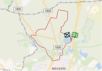
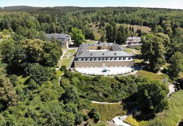
Trail On foot of 7.1 km to be discovered at Southwest, Plzeňský kraj, Plzeň. This trail is proposed by SityTrail - itinéraires balisés pédestres.
Description
Trail created by cz:KČT.
Značena žlutým pásovým značením
Positioning
Country:
Czech Republic
Region :
Southwest
Department/Province :
Plzeňský kraj
Municipality :
Plzeň
Location:
Unknown
Start:(Dec)
Start:(UTM)
383636 ; 5516513 (33U) N.
Comments
Trails nearby
![Trail On foot Přívětice - [Ž] Na Kramářské - Radeč západ - Photo](https://media.geolcdn.com/t/375/260/0c2b8328-b17d-4cb4-860a-465cc95b241f.jpeg&format=jpg&maxdim=2)
![On foot On foot](https://static1.geolcdn.com/sitytour/trail-icons/100.png)
[Ž] Na Kramářské - Radeč západ
On foot
Easy
Přívětice,
Southwest,
Plzeňský kraj,
Czech Republic
![](/images/other/stat-length.png)
3.1 km | 3.8 km-effort
52min
![](https://static1.geolcdn.com/siteimages/upload/files/16400158638029165_repeat_loop_refresh_sync_direction_icon.png)
No
![Trail On foot Líně - [Č] Líňská okružní trasa - Photo](https://media.geolcdn.com/t/375/260/cbeb49cd-7fbd-4b7b-bd64-d76bac41e164.jpeg&format=jpg&maxdim=2)
![On foot On foot](https://static1.geolcdn.com/sitytour/trail-icons/100.png)
[Č] Líňská okružní trasa
On foot
Easy
Líně,
Southwest,
Plzeňský kraj,
Czech Republic
![](/images/other/stat-length.png)
12.1 km | 13.9 km-effort
3h 9min
![](https://static1.geolcdn.com/siteimages/upload/files/16400158638029165_repeat_loop_refresh_sync_direction_icon.png)
Yes
![Trail On foot Chrást - Naučná stezka Chrást - Photo](https://media.geolcdn.com/t/375/260/2d94c3d4-6192-4d3a-a905-f806b8213e86.jpeg&format=jpg&maxdim=2)
![On foot On foot](https://static1.geolcdn.com/sitytour/trail-icons/100.png)
Naučná stezka Chrást
On foot
Easy
Chrást,
Southwest,
Plzeňský kraj,
Czech Republic
![](/images/other/stat-length.png)
7.8 km | 9.3 km-effort
2h 6min
![](https://static1.geolcdn.com/siteimages/upload/files/16400158638029165_repeat_loop_refresh_sync_direction_icon.png)
Yes
![Trail On foot Bušovice - naučná stezka Kokotské rybníky - Photo](https://media.geolcdn.com/t/375/260/21be398b-ed89-4710-b2df-2efebd80e609.jpeg&format=jpg&maxdim=2)
![On foot On foot](https://static1.geolcdn.com/sitytour/trail-icons/100.png)
naučná stezka Kokotské rybníky
On foot
Easy
Bušovice,
Southwest,
Plzeňský kraj,
Czech Republic
![](/images/other/stat-length.png)
9.1 km | 12.5 km-effort
2h 50min
![](https://static1.geolcdn.com/siteimages/upload/files/16400158638029165_repeat_loop_refresh_sync_direction_icon.png)
Yes
![Trail On foot Šťáhlavy - Naučná stezka Okolo Kozlu - Photo](https://media.geolcdn.com/t/375/260/6ab8b0a3-a73f-4f06-abb5-727e8ac683f0.jpeg&format=jpg&maxdim=2)
![On foot On foot](https://static1.geolcdn.com/sitytour/trail-icons/100.png)
Naučná stezka Okolo Kozlu
On foot
Easy
Šťáhlavy,
Southwest,
Plzeňský kraj,
Czech Republic
![](/images/other/stat-length.png)
3.3 km | 4.4 km-effort
59min
![](https://static1.geolcdn.com/siteimages/upload/files/16400158638029165_repeat_loop_refresh_sync_direction_icon.png)
Yes
![Trail On foot Plasy - NS Ludvíka Očenáška - Photo](https://media.geolcdn.com/t/375/260/896bf5cf-f443-487e-be76-ba92d469daf4.jpeg&format=jpg&maxdim=2)
![On foot On foot](https://static1.geolcdn.com/sitytour/trail-icons/100.png)
NS Ludvíka Očenáška
On foot
Easy
Plasy,
Southwest,
Plzeňský kraj,
Czech Republic
![](/images/other/stat-length.png)
12.6 km | 16.6 km-effort
3h 46min
![](https://static1.geolcdn.com/siteimages/upload/files/16400158638029165_repeat_loop_refresh_sync_direction_icon.png)
No
![Trail On foot Hradec - [Z] Hradec - Vytůň - Photo](https://media.geolcdn.com/t/375/260/36372a90-b81a-4a71-9876-a3bf9f884ffe.jpeg&format=jpg&maxdim=2)
![On foot On foot](https://static1.geolcdn.com/sitytour/trail-icons/100.png)
[Z] Hradec - Vytůň
On foot
Easy
Hradec,
Southwest,
Plzeňský kraj,
Czech Republic
![](/images/other/stat-length.png)
11.8 km | 15.7 km-effort
3h 33min
![](https://static1.geolcdn.com/siteimages/upload/files/16400158638029165_repeat_loop_refresh_sync_direction_icon.png)
No
![Trail On foot Stod - [Ž] Stod - Vytůň - Photo](https://media.geolcdn.com/t/375/260/5f465939-ef20-4d07-aeae-d7b7b507e19b.jpeg&format=jpg&maxdim=2)
![On foot On foot](https://static1.geolcdn.com/sitytour/trail-icons/100.png)
[Ž] Stod - Vytůň
On foot
Easy
Stod,
Southwest,
Plzeňský kraj,
Czech Republic
![](/images/other/stat-length.png)
3.7 km | 4 km-effort
55min
![](https://static1.geolcdn.com/siteimages/upload/files/16400158638029165_repeat_loop_refresh_sync_direction_icon.png)
No
![Trail On foot Radnice - CZ-6612 - Photo](https://media.geolcdn.com/t/375/260/0a97671e-d95d-49b0-ad70-fd0b477aaa9b.jpeg&format=jpg&maxdim=2)
![On foot On foot](https://static1.geolcdn.com/sitytour/trail-icons/100.png)
CZ-6612
On foot
Medium
Radnice,
Southwest,
Plzeňský kraj,
Czech Republic
![](/images/other/stat-length.png)
23 km | 29 km-effort
6h 29min
![](https://static1.geolcdn.com/siteimages/upload/files/16400158638029165_repeat_loop_refresh_sync_direction_icon.png)
No