


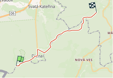

7.1 km | 8.3 km-effort
![Trail On foot Rozvadov - [Ž] Rybničná -;Pod ovčím kopcem - Photo](https://media.geolcdn.com/t/1900/400/cbd477a6-9e51-410c-896f-089efa643184.jpeg&format=pjpeg&maxdim=2)

Tous les sentiers balisés d’Europe GUIDE+


FREE GPS app for hiking
 SityTrail
IGN / Geographical institutes
SityTrail World
The world is yours!
Trail On foot of 9.1 km to be discovered at Southwest, Plzeňský kraj, Rozvadov. This trail is proposed by SityTrail - itinéraires balisés pédestres.
Trail created by cz:KČT.
![Trail On foot Rozvadov - [Ž] Rybničná -;Pod ovčím kopcem - Photo 1](https://media.geolcdn.com/t/2048/auto/7eb7e84f-8fbb-4fda-b6e6-6cc7aae7c6f1.jpeg&format=jpg&maxdim=0 "Trail On foot Rozvadov - [Ž] Rybničná -;Pod ovčím kopcem - Photo 1")
![Trail On foot Rozvadov - [Ž] Rybničná -;Pod ovčím kopcem - Photo 2](https://media.geolcdn.com/t/2048/auto/1205d877-83dd-4738-a85a-33004c194c9d.jpeg&format=jpg&maxdim=0 "Trail On foot Rozvadov - [Ž] Rybničná -;Pod ovčím kopcem - Photo 2")
![Trail On foot Rozvadov - [Ž] Rybničná -;Pod ovčím kopcem - Photo 3](https://media.geolcdn.com/t/2048/auto/52b9a604-eae6-4df5-a82e-42d5d52e5e4c.jpeg&format=jpg&maxdim=0 "Trail On foot Rozvadov - [Ž] Rybničná -;Pod ovčím kopcem - Photo 3")
![Trail On foot Rozvadov - [Ž] Rybničná -;Pod ovčím kopcem - Photo 4](https://media.geolcdn.com/t/2048/auto/878f673f-b357-4b52-bf0f-f38f348c03ab.jpeg&format=jpg&maxdim=0 "Trail On foot Rozvadov - [Ž] Rybničná -;Pod ovčím kopcem - Photo 4")
![Trail On foot Rozvadov - [Ž] Rybničná -;Pod ovčím kopcem - Photo 5](https://media.geolcdn.com/t/2048/auto/02455cf5-c01b-49fb-92c2-95c9513902aa.jpeg&format=jpg&maxdim=0 "Trail On foot Rozvadov - [Ž] Rybničná -;Pod ovčím kopcem - Photo 5")
![Trail On foot Rozvadov - [Ž] Rybničná -;Pod ovčím kopcem - Photo 6](https://media.geolcdn.com/t/2048/auto/5472cbf4-5682-4692-9d1b-62b536381bad.jpeg&format=jpg&maxdim=0 "Trail On foot Rozvadov - [Ž] Rybničná -;Pod ovčím kopcem - Photo 6")
![Trail On foot Rozvadov - [Ž] Rybničná -;Pod ovčím kopcem - Photo 7](https://media.geolcdn.com/t/2048/auto/48bd39eb-9e5f-4fa1-b21c-b0525a6f7f06.jpeg&format=jpg&maxdim=0 "Trail On foot Rozvadov - [Ž] Rybničná -;Pod ovčím kopcem - Photo 7")
![Trail On foot Rozvadov - [Ž] Rybničná -;Pod ovčím kopcem - Photo 8](https://media.geolcdn.com/t/2048/auto/827b0a54-8c01-4f5c-986a-434b878e5841.jpeg&format=jpg&maxdim=0 "Trail On foot Rozvadov - [Ž] Rybničná -;Pod ovčím kopcem - Photo 8")
![Trail On foot Rozvadov - [Ž] Rybničná -;Pod ovčím kopcem - Photo 9](https://media.geolcdn.com/t/2048/auto/bb608e95-f837-4d89-9fd3-b3d5e0e3856c.jpeg&format=jpg&maxdim=0 "Trail On foot Rozvadov - [Ž] Rybničná -;Pod ovčím kopcem - Photo 9")
![Trail On foot Rozvadov - [Ž] Rybničná -;Pod ovčím kopcem - Photo 10](https://media.geolcdn.com/t/2048/auto/cbd477a6-9e51-410c-896f-089efa643184.jpeg&format=jpg&maxdim=0 "Trail On foot Rozvadov - [Ž] Rybničná -;Pod ovčím kopcem - Photo 10")
On foot

Electric bike