


6 km | 7.8 km-effort
![Trail On foot Želízy - [Ž] Želízy - Štětí - Photo](https://media.geolcdn.com/t/1900/400/5fe56eac-7584-4af0-9a4b-860224c197e4.jpeg&format=pjpeg&maxdim=2)

Tous les sentiers balisés d’Europe GUIDE+


FREE GPS app for hiking
 SityTrail
IGN / Geographical institutes
SityTrail World
The world is yours!
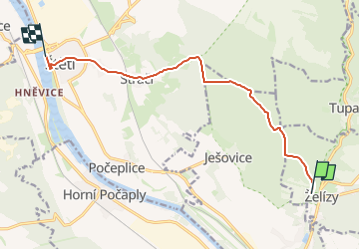
Trail On foot of 9.5 km to be discovered at Central Bohemia, Unknown, Želízy. This trail is proposed by SityTrail - itinéraires balisés pédestres.
Trail created by cz:KČT.
okružní trasa
![Trail On foot Želízy - [Ž] Želízy - Štětí - Photo 1](https://media.geolcdn.com/t/2048/auto/8b0fb4f1-deb4-42ed-9cbc-6dffb132ac9e.jpeg&format=jpg&maxdim=0 "Trail On foot Želízy - [Ž] Želízy - Štětí - Photo 1")
![Trail On foot Želízy - [Ž] Želízy - Štětí - Photo 2](https://media.geolcdn.com/t/2048/auto/6e5bb9ed-f013-45cb-8de8-85805ed3da6a.jpeg&format=jpg&maxdim=0 "Trail On foot Želízy - [Ž] Želízy - Štětí - Photo 2")
![Trail On foot Želízy - [Ž] Želízy - Štětí - Photo 3](https://media.geolcdn.com/t/2048/auto/6b626a54-c716-4048-bea0-852e2810f550.jpeg&format=jpg&maxdim=0 "Trail On foot Želízy - [Ž] Želízy - Štětí - Photo 3")
![Trail On foot Želízy - [Ž] Želízy - Štětí - Photo 4](https://media.geolcdn.com/t/2048/auto/bd0c91e9-d103-4ff7-9805-29aa3b9692a5.jpeg&format=jpg&maxdim=0 "Trail On foot Želízy - [Ž] Želízy - Štětí - Photo 4")
![Trail On foot Želízy - [Ž] Želízy - Štětí - Photo 5](https://media.geolcdn.com/t/2048/auto/a12a3d44-f4a7-4d4f-9af0-6ca2bb1c0b3c.jpeg&format=jpg&maxdim=0 "Trail On foot Želízy - [Ž] Želízy - Štětí - Photo 5")
![Trail On foot Želízy - [Ž] Želízy - Štětí - Photo 6](https://media.geolcdn.com/t/2048/auto/c7e978e4-a2c5-4ed3-99b9-53a644fabc1c.jpeg&format=jpg&maxdim=0 "Trail On foot Želízy - [Ž] Želízy - Štětí - Photo 6")
![Trail On foot Želízy - [Ž] Želízy - Štětí - Photo 7](https://media.geolcdn.com/t/2048/auto/03b7f7f4-9a69-4c34-ace8-78ab41c17b45.jpeg&format=jpg&maxdim=0 "Trail On foot Želízy - [Ž] Želízy - Štětí - Photo 7")
![Trail On foot Želízy - [Ž] Želízy - Štětí - Photo 8](https://media.geolcdn.com/t/2048/auto/33b8f87f-9863-4bb2-955b-bb0674048efa.jpeg&format=jpg&maxdim=0 "Trail On foot Želízy - [Ž] Želízy - Štětí - Photo 8")
![Trail On foot Želízy - [Ž] Želízy - Štětí - Photo 9](https://media.geolcdn.com/t/2048/auto/44eec9f1-180d-46b3-8a16-3ec3b79911a1.jpeg&format=jpg&maxdim=0 "Trail On foot Želízy - [Ž] Želízy - Štětí - Photo 9")
![Trail On foot Želízy - [Ž] Želízy - Štětí - Photo 10](https://media.geolcdn.com/t/2048/auto/5fe56eac-7584-4af0-9a4b-860224c197e4.jpeg&format=jpg&maxdim=0 "Trail On foot Želízy - [Ž] Želízy - Štětí - Photo 10")
![Trail On foot Želízy - [M] Kokořín - Zimořský důl - Photo](https://media.geolcdn.com/t/375/260/04ffd1a5-afe9-4e85-be18-0b7b38d70abe.jpeg&format=jpg&maxdim=2)
On foot
![Trail On foot Liběchov - [M] Okruh Václava Levého - Photo](https://media.geolcdn.com/t/375/260/e5904d4a-7cd6-4b86-95b3-486fa6e70af0.jpeg&format=jpg&maxdim=2)
On foot