


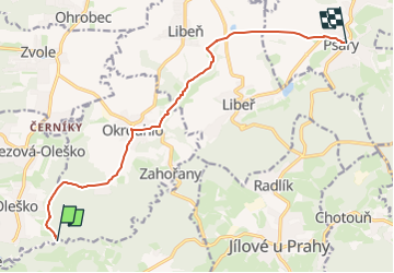

10.7 km | 14.1 km-effort
![Trail On foot Březová-Oleško - [Ž] Na Dolech-Psáry - Photo](https://media.geolcdn.com/t/1900/400/5eaa306a-6bcd-49ff-9f66-a7c38f811023.jpeg&format=pjpeg&maxdim=2)

Tous les sentiers balisés d’Europe GUIDE+


FREE GPS app for hiking
 SityTrail
IGN / Geographical institutes
SityTrail World
The world is yours!
Trail On foot of 10.3 km to be discovered at Central Bohemia, Unknown, Březová-Oleško. This trail is proposed by SityTrail - itinéraires balisés pédestres.
Trail created by cz:KČT.
![Trail On foot Březová-Oleško - [Ž] Na Dolech-Psáry - Photo 1](https://media.geolcdn.com/t/2048/auto/a70e231c-8369-43e8-bd0c-ee1bbc07a660.jpeg&format=jpg&maxdim=0 "Trail On foot Březová-Oleško - [Ž] Na Dolech-Psáry - Photo 1")
![Trail On foot Březová-Oleško - [Ž] Na Dolech-Psáry - Photo 2](https://media.geolcdn.com/t/2048/auto/f525df68-ec26-4f46-8cfe-83c00138d5cc.jpeg&format=jpg&maxdim=0 "Trail On foot Březová-Oleško - [Ž] Na Dolech-Psáry - Photo 2")
![Trail On foot Březová-Oleško - [Ž] Na Dolech-Psáry - Photo 3](https://media.geolcdn.com/t/2048/auto/005df11d-5d5d-49aa-aaf3-36d2904f54ac.jpeg&format=jpg&maxdim=0 "Trail On foot Březová-Oleško - [Ž] Na Dolech-Psáry - Photo 3")
![Trail On foot Březová-Oleško - [Ž] Na Dolech-Psáry - Photo 4](https://media.geolcdn.com/t/2048/auto/9ceb4fcc-0621-4259-ae32-4d912c950c43.jpeg&format=jpg&maxdim=0 "Trail On foot Březová-Oleško - [Ž] Na Dolech-Psáry - Photo 4")
![Trail On foot Březová-Oleško - [Ž] Na Dolech-Psáry - Photo 5](https://media.geolcdn.com/t/2048/auto/94111a7f-104d-43c5-818d-ccc4cda4443f.jpeg&format=jpg&maxdim=0 "Trail On foot Březová-Oleško - [Ž] Na Dolech-Psáry - Photo 5")
![Trail On foot Březová-Oleško - [Ž] Na Dolech-Psáry - Photo 6](https://media.geolcdn.com/t/2048/auto/1b252226-74d1-4b53-8751-b7ecd9ea2482.jpeg&format=jpg&maxdim=0 "Trail On foot Březová-Oleško - [Ž] Na Dolech-Psáry - Photo 6")
![Trail On foot Březová-Oleško - [Ž] Na Dolech-Psáry - Photo 7](https://media.geolcdn.com/t/2048/auto/cb219aba-8793-464c-94c8-adbb11cfdaa9.jpeg&format=jpg&maxdim=0 "Trail On foot Březová-Oleško - [Ž] Na Dolech-Psáry - Photo 7")
![Trail On foot Březová-Oleško - [Ž] Na Dolech-Psáry - Photo 8](https://media.geolcdn.com/t/2048/auto/df10b9ce-44b4-45bb-b6bd-004df20d3afe.jpeg&format=jpg&maxdim=0 "Trail On foot Březová-Oleško - [Ž] Na Dolech-Psáry - Photo 8")
![Trail On foot Březová-Oleško - [Ž] Na Dolech-Psáry - Photo 9](https://media.geolcdn.com/t/2048/auto/ce9f49ea-92c5-44e8-8cc3-11bd48f17384.jpeg&format=jpg&maxdim=0 "Trail On foot Březová-Oleško - [Ž] Na Dolech-Psáry - Photo 9")
![Trail On foot Březová-Oleško - [Ž] Na Dolech-Psáry - Photo 10](https://media.geolcdn.com/t/2048/auto/5eaa306a-6bcd-49ff-9f66-a7c38f811023.jpeg&format=jpg&maxdim=0 "Trail On foot Březová-Oleško - [Ž] Na Dolech-Psáry - Photo 10")

Motorboat
![Trail On foot Měchenice - [M] Měchenice - Všenory - Photo](https://media.geolcdn.com/t/375/260/06630537-e029-451b-a301-b274a78a918c.jpeg&format=jpg&maxdim=2)
On foot
On foot
![Trail On foot Petrov - [Č] Jílovské vyhlídky - okruh - Photo](https://media.geolcdn.com/t/375/260/79529de6-ead8-47c9-94dd-a6d50a4da4ed.jpeg&format=jpg&maxdim=2)
On foot
![Trail On foot Krňany - [Z] Pikovice - Pod Třebsínem - Photo](https://media.geolcdn.com/t/375/260/9d973daa-efdc-425c-b30b-77795e7c71fa.jpeg&format=jpg&maxdim=2)
On foot
![Trail On foot Kamenný Přívoz - [M] Štěchovice-Žampach - Photo](https://media.geolcdn.com/t/375/260/a821c811-bd4f-4f8f-981b-9700e5481d50.jpeg&format=jpg&maxdim=2)
On foot
![Trail On foot Zvole - [Ž] Vrané - Ohrobská - Photo](https://media.geolcdn.com/t/375/260/2b998145-2f51-4216-98cc-0d1c0929ad72.jpeg&format=jpg&maxdim=2)
On foot
![Trail On foot Davle - [Ž] Davle - Jílové u P. - Photo](https://media.geolcdn.com/t/375/260/565e6ba4-c226-4a61-be53-789e63a62320.jpeg&format=jpg&maxdim=2)
On foot
![Trail On foot Jílové u Prahy - [M] Luka pod Medníkem - Těptín - Photo](https://media.geolcdn.com/t/375/260/13918b73-d9c0-43e5-94f7-fc0ab83a603d.jpeg&format=jpg&maxdim=2)
On foot