


1.9 km | 2.6 km-effort
![Trail On foot Benešov - [Ž] Benešov - Týnec n. Sázavou - Photo](https://media.geolcdn.com/t/1900/400/a945f703-f7b0-46ec-baf8-bf941e8d859d.jpeg&format=pjpeg&maxdim=2)

Tous les sentiers balisés d’Europe GUIDE+


FREE GPS app for hiking
 SityTrail
IGN / Geographical institutes
SityTrail World
The world is yours!
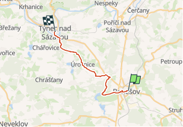
Trail On foot of 13.5 km to be discovered at Central Bohemia, Unknown, Benešov. This trail is proposed by SityTrail - itinéraires balisés pédestres.
Trail created by cz:KČT.
![Trail On foot Benešov - [Ž] Benešov - Týnec n. Sázavou - Photo 1](https://media.geolcdn.com/t/2048/auto/bd3e1be2-a1a2-494d-b4ad-d95cda30c8c5.jpeg&format=jpg&maxdim=0 "Trail On foot Benešov - [Ž] Benešov - Týnec n. Sázavou - Photo 1")
![Trail On foot Benešov - [Ž] Benešov - Týnec n. Sázavou - Photo 2](https://media.geolcdn.com/t/2048/auto/2cec06e5-377e-4d7f-bcde-1bcce0ba7ca1.jpeg&format=jpg&maxdim=0 "Trail On foot Benešov - [Ž] Benešov - Týnec n. Sázavou - Photo 2")
![Trail On foot Benešov - [Ž] Benešov - Týnec n. Sázavou - Photo 3](https://media.geolcdn.com/t/2048/auto/30c12a24-2f52-49dd-adcc-8c730ffd2bf3.jpeg&format=jpg&maxdim=0 "Trail On foot Benešov - [Ž] Benešov - Týnec n. Sázavou - Photo 3")
![Trail On foot Benešov - [Ž] Benešov - Týnec n. Sázavou - Photo 4](https://media.geolcdn.com/t/2048/auto/a182edee-0895-4916-b24f-cbe22c6c78e5.jpeg&format=jpg&maxdim=0 "Trail On foot Benešov - [Ž] Benešov - Týnec n. Sázavou - Photo 4")
![Trail On foot Benešov - [Ž] Benešov - Týnec n. Sázavou - Photo 5](https://media.geolcdn.com/t/2048/auto/46bfa17a-e8e1-4975-81f3-4d217765d298.jpeg&format=jpg&maxdim=0 "Trail On foot Benešov - [Ž] Benešov - Týnec n. Sázavou - Photo 5")
![Trail On foot Benešov - [Ž] Benešov - Týnec n. Sázavou - Photo 6](https://media.geolcdn.com/t/2048/auto/5b17d06c-0efd-4270-b6a7-8d9532d530f0.jpeg&format=jpg&maxdim=0 "Trail On foot Benešov - [Ž] Benešov - Týnec n. Sázavou - Photo 6")
![Trail On foot Benešov - [Ž] Benešov - Týnec n. Sázavou - Photo 7](https://media.geolcdn.com/t/2048/auto/f81a6ba4-106e-4a5a-94c2-88597a0ffb60.jpeg&format=jpg&maxdim=0 "Trail On foot Benešov - [Ž] Benešov - Týnec n. Sázavou - Photo 7")
![Trail On foot Benešov - [Ž] Benešov - Týnec n. Sázavou - Photo 8](https://media.geolcdn.com/t/2048/auto/d4e534c5-e70a-41b9-85fa-6c7fd99bc4d6.jpeg&format=jpg&maxdim=0 "Trail On foot Benešov - [Ž] Benešov - Týnec n. Sázavou - Photo 8")
![Trail On foot Benešov - [Ž] Benešov - Týnec n. Sázavou - Photo 9](https://media.geolcdn.com/t/2048/auto/3bb5e115-278c-48a6-b27a-3c0fb5eb5e94.jpeg&format=jpg&maxdim=0 "Trail On foot Benešov - [Ž] Benešov - Týnec n. Sázavou - Photo 9")
![Trail On foot Benešov - [Ž] Benešov - Týnec n. Sázavou - Photo 10](https://media.geolcdn.com/t/2048/auto/a945f703-f7b0-46ec-baf8-bf941e8d859d.jpeg&format=jpg&maxdim=0 "Trail On foot Benešov - [Ž] Benešov - Týnec n. Sázavou - Photo 10")

Walking