


13 km | 17 km-effort
![Trail On foot Neveklov - [Z] Neštětice - Týnec n. S. - Photo](https://media.geolcdn.com/t/1900/400/a945f703-f7b0-46ec-baf8-bf941e8d859d.jpeg&format=pjpeg&maxdim=2)

Tous les sentiers balisés d’Europe GUIDE+


FREE GPS app for hiking
 SityTrail
IGN / Geographical institutes
SityTrail World
The world is yours!
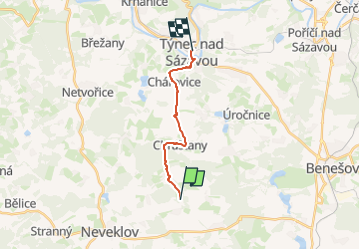
Trail On foot of 10.6 km to be discovered at Central Bohemia, Unknown, Neveklov. This trail is proposed by SityTrail - itinéraires balisés pédestres.
Trail created by cz:KČT.
![Trail On foot Neveklov - [Z] Neštětice - Týnec n. S. - Photo 1](https://media.geolcdn.com/t/2048/auto/7fb14924-5869-43b8-a54f-bec28f6ddbff.jpeg&format=jpg&maxdim=0 "Trail On foot Neveklov - [Z] Neštětice - Týnec n. S. - Photo 1")
![Trail On foot Neveklov - [Z] Neštětice - Týnec n. S. - Photo 2](https://media.geolcdn.com/t/2048/auto/8b28d339-ac11-4c4f-b360-391919a6228e.jpeg&format=jpg&maxdim=0 "Trail On foot Neveklov - [Z] Neštětice - Týnec n. S. - Photo 2")
![Trail On foot Neveklov - [Z] Neštětice - Týnec n. S. - Photo 3](https://media.geolcdn.com/t/2048/auto/24771d2b-726c-403e-bba7-7e71c8892cec.jpeg&format=jpg&maxdim=0 "Trail On foot Neveklov - [Z] Neštětice - Týnec n. S. - Photo 3")
![Trail On foot Neveklov - [Z] Neštětice - Týnec n. S. - Photo 4](https://media.geolcdn.com/t/2048/auto/2302cd8e-56ae-4265-89bd-22c7a9e99b82.jpeg&format=jpg&maxdim=0 "Trail On foot Neveklov - [Z] Neštětice - Týnec n. S. - Photo 4")
![Trail On foot Neveklov - [Z] Neštětice - Týnec n. S. - Photo 5](https://media.geolcdn.com/t/2048/auto/508c9d97-7192-42a1-8cbe-c9d5eabc713e.jpeg&format=jpg&maxdim=0 "Trail On foot Neveklov - [Z] Neštětice - Týnec n. S. - Photo 5")
![Trail On foot Neveklov - [Z] Neštětice - Týnec n. S. - Photo 6](https://media.geolcdn.com/t/2048/auto/7942c2bc-9289-4fb1-8917-9ee66540335c.jpeg&format=jpg&maxdim=0 "Trail On foot Neveklov - [Z] Neštětice - Týnec n. S. - Photo 6")
![Trail On foot Neveklov - [Z] Neštětice - Týnec n. S. - Photo 7](https://media.geolcdn.com/t/2048/auto/bf9d3e10-783f-4745-85b5-ffa7693543cd.jpeg&format=jpg&maxdim=0 "Trail On foot Neveklov - [Z] Neštětice - Týnec n. S. - Photo 7")
![Trail On foot Neveklov - [Z] Neštětice - Týnec n. S. - Photo 8](https://media.geolcdn.com/t/2048/auto/d89a6a82-9363-4f60-a257-46c10c11f964.jpeg&format=jpg&maxdim=0 "Trail On foot Neveklov - [Z] Neštětice - Týnec n. S. - Photo 8")
![Trail On foot Neveklov - [Z] Neštětice - Týnec n. S. - Photo 9](https://media.geolcdn.com/t/2048/auto/3e7a4176-2673-4e5a-8a20-d5c04ac67be6.jpeg&format=jpg&maxdim=0 "Trail On foot Neveklov - [Z] Neštětice - Týnec n. S. - Photo 9")
![Trail On foot Neveklov - [Z] Neštětice - Týnec n. S. - Photo 10](https://media.geolcdn.com/t/2048/auto/a945f703-f7b0-46ec-baf8-bf941e8d859d.jpeg&format=jpg&maxdim=0 "Trail On foot Neveklov - [Z] Neštětice - Týnec n. S. - Photo 10")
![Trail On foot Neveklov - [Č] Neveklov - Nová Živohošť - Photo](https://media.geolcdn.com/t/375/260/9b3b6318-c1d7-44e1-874f-d705bb4beb87.jpeg&format=jpg&maxdim=2)
On foot