


70 km | 82 km-effort
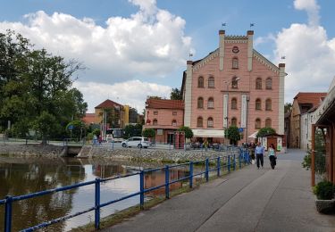
![Trail On foot Nasavrky - [Ž] Nasavrky - Lapáčkův mlýn - Photo](https://media.geolcdn.com/t/1900/400/bb079db1-0777-4b21-9bd1-68ff745e3576.jpeg&format=pjpeg&maxdim=2)

Tous les sentiers balisés d’Europe GUIDE+


FREE GPS app for hiking
 SityTrail
IGN / Geographical institutes
SityTrail World
The world is yours!
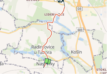
Trail On foot of 3.6 km to be discovered at Southwest, Jihočeský kraj, Nasavrky. This trail is proposed by SityTrail - itinéraires balisés pédestres.
Trail created by cz:KČT.
![Trail On foot Nasavrky - [Ž] Nasavrky - Lapáčkův mlýn - Photo 1](https://media.geolcdn.com/t/2048/auto/5f5abcff-9177-4e11-8e2b-ad2127979492.jpeg&format=jpg&maxdim=0 "Trail On foot Nasavrky - [Ž] Nasavrky - Lapáčkův mlýn - Photo 1")
![Trail On foot Nasavrky - [Ž] Nasavrky - Lapáčkův mlýn - Photo 2](https://media.geolcdn.com/t/2048/auto/0aa4ef9e-60dd-440b-9842-61c5ee8e070b.jpeg&format=jpg&maxdim=0 "Trail On foot Nasavrky - [Ž] Nasavrky - Lapáčkův mlýn - Photo 2")
![Trail On foot Nasavrky - [Ž] Nasavrky - Lapáčkův mlýn - Photo 3](https://media.geolcdn.com/t/2048/auto/2105c12f-6414-4fe5-a3b5-835cf0688d0a.jpeg&format=jpg&maxdim=0 "Trail On foot Nasavrky - [Ž] Nasavrky - Lapáčkův mlýn - Photo 3")
![Trail On foot Nasavrky - [Ž] Nasavrky - Lapáčkův mlýn - Photo 4](https://media.geolcdn.com/t/2048/auto/4bdfd3a0-4ff8-4f49-9e46-e0bdb6e9efef.jpeg&format=jpg&maxdim=0 "Trail On foot Nasavrky - [Ž] Nasavrky - Lapáčkův mlýn - Photo 4")
![Trail On foot Nasavrky - [Ž] Nasavrky - Lapáčkův mlýn - Photo 5](https://media.geolcdn.com/t/2048/auto/bb079db1-0777-4b21-9bd1-68ff745e3576.jpeg&format=jpg&maxdim=0 "Trail On foot Nasavrky - [Ž] Nasavrky - Lapáčkův mlýn - Photo 5")
Other activity
![Trail On foot Chotoviny - [Ž] U Obrázku - Sudoměřice - Chotoviny - Photo](https://media.geolcdn.com/t/375/260/f7339841-f981-41ea-8ead-dcdc4c14e1ae.jpeg&format=jpg&maxdim=2)
On foot