Trail On foot Rokytnice nad Jizerou - CZ-4326 - Photo

Tous les sentiers balisés d’Europe GUIDE+

© OpenStreetMap contributors
Length
Length
7.9 km
Max alt
Max alt
948 m
Uphill gradient
Uphill gradient
443 m
Km-Effort
Km-Effort  
13.3 km
Min alt
Min alt
536 m
Downhill gradient
Downhill gradient
288 m
Boucle
Boucle
No
Signpost
Signpost
Creation date :
2025-02-06 17:41:53.819
Updated on :
2025-02-06 17:41:53.819

(0 Reviews)

On foot
On foot
3h01
Difficulty : Easy

Scan this QR Code to open this trail in the SityTrail application

FREE GPS app for hiking

Logo SityTrail SityTrail

IGN / Geographical institutes

Download SityTrail from the App Store Download SityTrail from Google Play

Logo SityTrail SityTrail World

The world is yours!

Download SityTrail from the App Store Download SityTrail from Google Play Download SityTrail on Huawei AppGallery

About

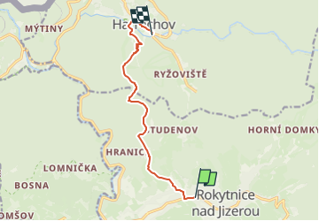
Trail On foot of 7.9 km to be discovered at Northeast, Liberecký kraj, Rokytnice nad Jizerou. This trail is proposed by SityTrail - itinéraires balisés pédestres.

Description

Trail created by cz:KČT.

Elevation profile

Photos

Positioning

Country:
Czech Republic
Region :
Northeast
Department/Province :
Liberecký kraj
Municipality :
Rokytnice nad Jizerou
Location:
Unknown
Start:(UTM)
531870 ; 5619821 (33U) N.

Trails nearby

Trail On foot Jablonec nad Jizerou - [Ž] Jablonec n. Jiz. - Hvězda - Photo
On foot
GUIDE+

On foot

Easy
Jablonec nad Jizerou, Northeast, Liberecký kraj, Czech Republic
8.6 km | 13.8 km-effort
3h 7min
No
Trail On foot Rokytnice nad Jizerou - CZ-4286 - Photo
On foot
GUIDE+

On foot

Easy
Rokytnice nad Jizerou, Northeast, Liberecký kraj, Czech Republic
3.2 km | 4.4 km-effort
59min
No


Close
My subscriptions