


22 km | 28 km-effort
![Trail On foot Rozdrojovice - [M] Žebětín - Rozdrojovice - Photo](https://media.geolcdn.com/t/1900/400/682a79b8-a1d7-45d4-a97b-8208da66a550.jpeg&format=pjpeg&maxdim=2)

Tous les sentiers balisés d’Europe GUIDE+


FREE GPS app for hiking
 SityTrail
IGN / Geographical institutes
SityTrail World
The world is yours!
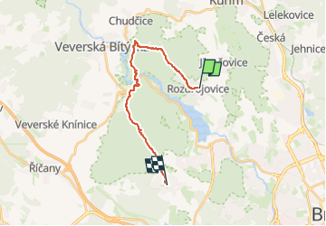
Trail On foot of 15.2 km to be discovered at Southeast, Jihomoravský kraj, Rozdrojovice. This trail is proposed by SityTrail - itinéraires balisés pédestres.
Trail created by cz:KČT.
![Trail On foot Rozdrojovice - [M] Žebětín - Rozdrojovice - Photo 1](https://media.geolcdn.com/t/2048/auto/50d34357-2f81-40fb-817c-45f7e64ed56c.jpeg&format=jpg&maxdim=0 "Trail On foot Rozdrojovice - [M] Žebětín - Rozdrojovice - Photo 1")
![Trail On foot Rozdrojovice - [M] Žebětín - Rozdrojovice - Photo 2](https://media.geolcdn.com/t/2048/auto/6c13168c-af2e-460f-84dd-59407168a161.jpeg&format=jpg&maxdim=0 "Trail On foot Rozdrojovice - [M] Žebětín - Rozdrojovice - Photo 2")
![Trail On foot Rozdrojovice - [M] Žebětín - Rozdrojovice - Photo 3](https://media.geolcdn.com/t/2048/auto/afeec0c4-9546-4731-a38d-347fae34a55b.jpeg&format=jpg&maxdim=0 "Trail On foot Rozdrojovice - [M] Žebětín - Rozdrojovice - Photo 3")
![Trail On foot Rozdrojovice - [M] Žebětín - Rozdrojovice - Photo 4](https://media.geolcdn.com/t/2048/auto/7eefc4e0-9840-4662-9408-c28de6874aec.jpeg&format=jpg&maxdim=0 "Trail On foot Rozdrojovice - [M] Žebětín - Rozdrojovice - Photo 4")
![Trail On foot Rozdrojovice - [M] Žebětín - Rozdrojovice - Photo 5](https://media.geolcdn.com/t/2048/auto/36ecabe0-de99-4d6e-a664-7a4740d1f3bd.jpeg&format=jpg&maxdim=0 "Trail On foot Rozdrojovice - [M] Žebětín - Rozdrojovice - Photo 5")
![Trail On foot Rozdrojovice - [M] Žebětín - Rozdrojovice - Photo 6](https://media.geolcdn.com/t/2048/auto/fdc97ba2-f1cf-495c-a714-a62ce5368f2c.jpeg&format=jpg&maxdim=0 "Trail On foot Rozdrojovice - [M] Žebětín - Rozdrojovice - Photo 6")
![Trail On foot Rozdrojovice - [M] Žebětín - Rozdrojovice - Photo 7](https://media.geolcdn.com/t/2048/auto/ad4e4c6b-728c-4aa3-ac72-4ddfbae952fd.jpeg&format=jpg&maxdim=0 "Trail On foot Rozdrojovice - [M] Žebětín - Rozdrojovice - Photo 7")
![Trail On foot Rozdrojovice - [M] Žebětín - Rozdrojovice - Photo 8](https://media.geolcdn.com/t/2048/auto/aecf5aa1-7fd2-41a2-ba5d-a9297de5ed0e.jpeg&format=jpg&maxdim=0 "Trail On foot Rozdrojovice - [M] Žebětín - Rozdrojovice - Photo 8")
![Trail On foot Rozdrojovice - [M] Žebětín - Rozdrojovice - Photo 9](https://media.geolcdn.com/t/2048/auto/fe8138fb-c707-41e3-8089-a98f3c5c8063.jpeg&format=jpg&maxdim=0 "Trail On foot Rozdrojovice - [M] Žebětín - Rozdrojovice - Photo 9")
![Trail On foot Rozdrojovice - [M] Žebětín - Rozdrojovice - Photo 10](https://media.geolcdn.com/t/2048/auto/682a79b8-a1d7-45d4-a97b-8208da66a550.jpeg&format=jpg&maxdim=0 "Trail On foot Rozdrojovice - [M] Žebětín - Rozdrojovice - Photo 10")
![Trail On foot Brno - [Z] Devět křížů - Obora - Photo](https://media.geolcdn.com/t/375/260/ext.jpg?maxdim=2&url=https%3A%2F%2Fstatic1.geolcdn.com%2Fsiteimages%2Fupload%2Ffiles%2F1545311037marcheuse_200dpi.jpg)
On foot