


3.2 km | 5.1 km-effort
![Trail On foot Černošín - [Ž] Pod Třebelí - Volfštejn - Černošín - Krasíkov - Photo](https://media.geolcdn.com/t/1900/400/42da8eaf-ff34-45f0-a1bf-8ecf2b3765a4.jpeg&format=pjpeg&maxdim=2)

Tous les sentiers balisés d’Europe GUIDE+


FREE GPS app for hiking
 SityTrail
IGN / Geographical institutes
SityTrail World
The world is yours!
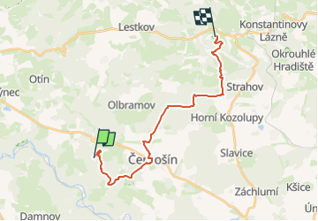
Trail On foot of 18.6 km to be discovered at Southwest, Plzeňský kraj, Černošín. This trail is proposed by SityTrail - itinéraires balisés pédestres.
Trail created by cz:KČT.
Zluta znacka
![Trail On foot Černošín - [Ž] Pod Třebelí - Volfštejn - Černošín - Krasíkov - Photo 1](https://media.geolcdn.com/t/2048/auto/b8ee5b9c-a932-4121-b2be-9045ead44b4a.jpeg&format=jpg&maxdim=0 "Trail On foot Černošín - [Ž] Pod Třebelí - Volfštejn - Černošín - Krasíkov - Photo 1")
![Trail On foot Černošín - [Ž] Pod Třebelí - Volfštejn - Černošín - Krasíkov - Photo 2](https://media.geolcdn.com/t/2048/auto/886b1a4a-74b8-4cd1-9d4c-38d2f605f27b.jpeg&format=jpg&maxdim=0 "Trail On foot Černošín - [Ž] Pod Třebelí - Volfštejn - Černošín - Krasíkov - Photo 2")
![Trail On foot Černošín - [Ž] Pod Třebelí - Volfštejn - Černošín - Krasíkov - Photo 3](https://media.geolcdn.com/t/2048/auto/b87b2a81-719b-46fb-8733-259a5d7e5f83.jpeg&format=jpg&maxdim=0 "Trail On foot Černošín - [Ž] Pod Třebelí - Volfštejn - Černošín - Krasíkov - Photo 3")
![Trail On foot Černošín - [Ž] Pod Třebelí - Volfštejn - Černošín - Krasíkov - Photo 4](https://media.geolcdn.com/t/2048/auto/ecb4936e-7481-4537-b861-f38fb40dfe0c.jpeg&format=jpg&maxdim=0 "Trail On foot Černošín - [Ž] Pod Třebelí - Volfštejn - Černošín - Krasíkov - Photo 4")
![Trail On foot Černošín - [Ž] Pod Třebelí - Volfštejn - Černošín - Krasíkov - Photo 5](https://media.geolcdn.com/t/2048/auto/8ae5c08d-fcc7-4cc5-838b-ee40e501acee.jpeg&format=jpg&maxdim=0 "Trail On foot Černošín - [Ž] Pod Třebelí - Volfštejn - Černošín - Krasíkov - Photo 5")
![Trail On foot Černošín - [Ž] Pod Třebelí - Volfštejn - Černošín - Krasíkov - Photo 6](https://media.geolcdn.com/t/2048/auto/bf00f8cd-dc81-459b-990c-ea725971ca70.jpeg&format=jpg&maxdim=0 "Trail On foot Černošín - [Ž] Pod Třebelí - Volfštejn - Černošín - Krasíkov - Photo 6")
![Trail On foot Černošín - [Ž] Pod Třebelí - Volfštejn - Černošín - Krasíkov - Photo 7](https://media.geolcdn.com/t/2048/auto/9433d059-8198-456a-8450-3b9c5f99d3cb.jpeg&format=jpg&maxdim=0 "Trail On foot Černošín - [Ž] Pod Třebelí - Volfštejn - Černošín - Krasíkov - Photo 7")
![Trail On foot Černošín - [Ž] Pod Třebelí - Volfštejn - Černošín - Krasíkov - Photo 8](https://media.geolcdn.com/t/2048/auto/c82cdaa3-38f6-48b8-873c-ebbc71494541.jpeg&format=jpg&maxdim=0 "Trail On foot Černošín - [Ž] Pod Třebelí - Volfštejn - Černošín - Krasíkov - Photo 8")
![Trail On foot Černošín - [Ž] Pod Třebelí - Volfštejn - Černošín - Krasíkov - Photo 9](https://media.geolcdn.com/t/2048/auto/ce01ffe3-0b54-4e46-bb52-6777c41831e2.jpeg&format=jpg&maxdim=0 "Trail On foot Černošín - [Ž] Pod Třebelí - Volfštejn - Černošín - Krasíkov - Photo 9")
![Trail On foot Černošín - [Ž] Pod Třebelí - Volfštejn - Černošín - Krasíkov - Photo 10](https://media.geolcdn.com/t/2048/auto/42da8eaf-ff34-45f0-a1bf-8ecf2b3765a4.jpeg&format=jpg&maxdim=0 "Trail On foot Černošín - [Ž] Pod Třebelí - Volfštejn - Černošín - Krasíkov - Photo 10")
![Trail On foot Ošelín - [Z] Ošelín - Nad Záhořím - Photo](https://media.geolcdn.com/t/375/260/95d79fd7-3d70-4242-a85e-dd68c90ddf1c.jpeg&format=jpg&maxdim=2)
On foot