


15.8 km | 21 km-effort
![Trail On foot Jílové u Prahy - [Z] Jílové-Kamenný přívoz - Photo](https://media.geolcdn.com/t/1900/400/f7bb2675-a287-4c84-9411-9fd978a7766c.jpeg&format=pjpeg&maxdim=2)

Tous les sentiers balisés d’Europe GUIDE+


FREE GPS app for hiking
 SityTrail
IGN / Geographical institutes
SityTrail World
The world is yours!
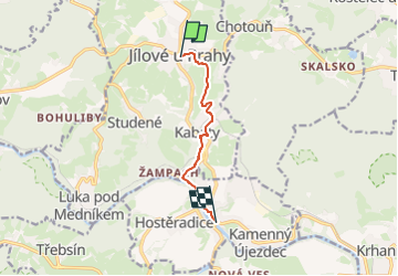
Trail On foot of 5.6 km to be discovered at Central Bohemia, Unknown, Jílové u Prahy. This trail is proposed by SityTrail - itinéraires balisés pédestres.
Trail created by cz:KČT.
![Trail On foot Jílové u Prahy - [Z] Jílové-Kamenný přívoz - Photo 1](https://media.geolcdn.com/t/2048/auto/09ad0493-172a-4009-93c2-e527015e9d72.jpeg&format=jpg&maxdim=0 "Trail On foot Jílové u Prahy - [Z] Jílové-Kamenný přívoz - Photo 1")
![Trail On foot Jílové u Prahy - [Z] Jílové-Kamenný přívoz - Photo 2](https://media.geolcdn.com/t/2048/auto/c209e0ef-c93e-4cca-a29e-609d700d873f.jpeg&format=jpg&maxdim=0 "Trail On foot Jílové u Prahy - [Z] Jílové-Kamenný přívoz - Photo 2")
![Trail On foot Jílové u Prahy - [Z] Jílové-Kamenný přívoz - Photo 3](https://media.geolcdn.com/t/2048/auto/5cddbd73-5f0f-40b6-8d36-4db9d756929f.jpeg&format=jpg&maxdim=0 "Trail On foot Jílové u Prahy - [Z] Jílové-Kamenný přívoz - Photo 3")
![Trail On foot Jílové u Prahy - [Z] Jílové-Kamenný přívoz - Photo 4](https://media.geolcdn.com/t/2048/auto/9c8f1206-0b59-4c1a-a49a-d991aca9dbca.jpeg&format=jpg&maxdim=0 "Trail On foot Jílové u Prahy - [Z] Jílové-Kamenný přívoz - Photo 4")
![Trail On foot Jílové u Prahy - [Z] Jílové-Kamenný přívoz - Photo 5](https://media.geolcdn.com/t/2048/auto/a96a4da2-f0c8-4163-a5cd-0c1cb5a0b223.jpeg&format=jpg&maxdim=0 "Trail On foot Jílové u Prahy - [Z] Jílové-Kamenný přívoz - Photo 5")
![Trail On foot Jílové u Prahy - [Z] Jílové-Kamenný přívoz - Photo 6](https://media.geolcdn.com/t/2048/auto/592d2497-c4da-43dd-a28f-ab0b5ff9fbcf.jpeg&format=jpg&maxdim=0 "Trail On foot Jílové u Prahy - [Z] Jílové-Kamenný přívoz - Photo 6")
![Trail On foot Jílové u Prahy - [Z] Jílové-Kamenný přívoz - Photo 7](https://media.geolcdn.com/t/2048/auto/541524b6-3704-488a-bb8a-99430638a52f.jpeg&format=jpg&maxdim=0 "Trail On foot Jílové u Prahy - [Z] Jílové-Kamenný přívoz - Photo 7")
![Trail On foot Jílové u Prahy - [Z] Jílové-Kamenný přívoz - Photo 8](https://media.geolcdn.com/t/2048/auto/46da66f2-2c1d-4617-a527-4ce7e5e32d91.jpeg&format=jpg&maxdim=0 "Trail On foot Jílové u Prahy - [Z] Jílové-Kamenný přívoz - Photo 8")
![Trail On foot Jílové u Prahy - [Z] Jílové-Kamenný přívoz - Photo 9](https://media.geolcdn.com/t/2048/auto/123cde16-9c45-46ee-81e6-63d2d49c64d4.jpeg&format=jpg&maxdim=0 "Trail On foot Jílové u Prahy - [Z] Jílové-Kamenný přívoz - Photo 9")
![Trail On foot Jílové u Prahy - [Z] Jílové-Kamenný přívoz - Photo 10](https://media.geolcdn.com/t/2048/auto/f7bb2675-a287-4c84-9411-9fd978a7766c.jpeg&format=jpg&maxdim=0 "Trail On foot Jílové u Prahy - [Z] Jílové-Kamenný přívoz - Photo 10")
![Trail On foot Petrov - [Č] Jílovské vyhlídky - okruh - Photo](https://media.geolcdn.com/t/375/260/79529de6-ead8-47c9-94dd-a6d50a4da4ed.jpeg&format=jpg&maxdim=2)
On foot
![Trail On foot Krňany - [Z] Pikovice - Pod Třebsínem - Photo](https://media.geolcdn.com/t/375/260/9d973daa-efdc-425c-b30b-77795e7c71fa.jpeg&format=jpg&maxdim=2)
On foot
![Trail On foot Kamenný Přívoz - [M] Štěchovice-Žampach - Photo](https://media.geolcdn.com/t/375/260/a821c811-bd4f-4f8f-981b-9700e5481d50.jpeg&format=jpg&maxdim=2)
On foot
![Trail On foot Kamenný Přívoz - [Ž] Jílové-Žampach - Photo](https://media.geolcdn.com/t/375/260/434c63fc-6fe3-4b0a-b856-0b7d89cd0676.jpeg&format=jpg&maxdim=2)
On foot
![Trail On foot Jílové u Prahy - [Z] Jílové - Libeř - Photo](https://media.geolcdn.com/t/375/260/03c11c27-8b15-4d10-932c-0290d35b865a.jpeg&format=jpg&maxdim=2)
On foot
![Trail On foot Kostelec u Křížků - [Z] Lojovice - Kostelec u křížků - Photo](https://media.geolcdn.com/t/375/260/f0b05652-4474-4782-a0c7-becaaa389d87.jpeg&format=jpg&maxdim=2)
On foot
![Trail On foot Sulice - [Ž] Hotel René - Prosečnice - Photo](https://media.geolcdn.com/t/375/260/d59bd23d-8349-4fb9-955f-584470061d09.jpeg&format=jpg&maxdim=2)
On foot
![Trail On foot Jílové u Prahy - [M] Luka pod Medníkem - Těptín - Photo](https://media.geolcdn.com/t/375/260/13918b73-d9c0-43e5-94f7-fc0ab83a603d.jpeg&format=jpg&maxdim=2)
On foot
![Trail On foot Jílové u Prahy - [Č] Zahořanský důl - Luka pod Medníkem - Photo](https://media.geolcdn.com/t/375/260/fea13c34-3c78-4f36-81cb-1806e5caa45a.jpeg&format=jpg&maxdim=2)
On foot