


3.9 km | 4.2 km-effort
![Trail On foot Unknown - [Ž] Jinonice - Geologická - Photo](https://media.geolcdn.com/t/1900/400/1a841737-89e3-42eb-987e-4ab272b28c15.jpeg&format=pjpeg&maxdim=2)

Tous les sentiers balisés d’Europe GUIDE+


FREE GPS app for hiking
 SityTrail
IGN / Geographical institutes
SityTrail World
The world is yours!
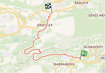
Trail On foot of 6.3 km to be discovered at Prague, Prague. This trail is proposed by SityTrail - itinéraires balisés pédestres.
Trail created by cz:KČT.
barrandov;klukovice;prokopské údolí;butovice;jinonice
![Trail On foot Unknown - [Ž] Jinonice - Geologická - Photo 1](https://media.geolcdn.com/t/2048/auto/70c9f079-5587-46b4-be2b-c14d9ff9a19d.jpeg&format=jpg&maxdim=0 "Trail On foot Unknown - [Ž] Jinonice - Geologická - Photo 1")
![Trail On foot Unknown - [Ž] Jinonice - Geologická - Photo 2](https://media.geolcdn.com/t/2048/auto/01135099-e2c6-490d-b47f-e2836666db2d.jpeg&format=jpg&maxdim=0 "Trail On foot Unknown - [Ž] Jinonice - Geologická - Photo 2")
![Trail On foot Unknown - [Ž] Jinonice - Geologická - Photo 3](https://media.geolcdn.com/t/2048/auto/b87acbcc-7af6-46e7-a73a-681b7c801314.jpeg&format=jpg&maxdim=0 "Trail On foot Unknown - [Ž] Jinonice - Geologická - Photo 3")
![Trail On foot Unknown - [Ž] Jinonice - Geologická - Photo 4](https://media.geolcdn.com/t/2048/auto/7302c085-2305-4dde-b894-ee833cffa1d9.jpeg&format=jpg&maxdim=0 "Trail On foot Unknown - [Ž] Jinonice - Geologická - Photo 4")
![Trail On foot Unknown - [Ž] Jinonice - Geologická - Photo 5](https://media.geolcdn.com/t/2048/auto/675891b6-a772-488c-a554-ac0b01b90c6f.jpeg&format=jpg&maxdim=0 "Trail On foot Unknown - [Ž] Jinonice - Geologická - Photo 5")
![Trail On foot Unknown - [Ž] Jinonice - Geologická - Photo 6](https://media.geolcdn.com/t/2048/auto/faad4776-61e4-4b25-8dc5-0dafe4e237ad.jpeg&format=jpg&maxdim=0 "Trail On foot Unknown - [Ž] Jinonice - Geologická - Photo 6")
![Trail On foot Unknown - [Ž] Jinonice - Geologická - Photo 7](https://media.geolcdn.com/t/2048/auto/12006ddd-8ca0-4f62-af26-a81a018c6102.jpeg&format=jpg&maxdim=0 "Trail On foot Unknown - [Ž] Jinonice - Geologická - Photo 7")
![Trail On foot Unknown - [Ž] Jinonice - Geologická - Photo 8](https://media.geolcdn.com/t/2048/auto/5d331be7-a97a-40fb-86f2-cbdef5e6c7a9.jpeg&format=jpg&maxdim=0 "Trail On foot Unknown - [Ž] Jinonice - Geologická - Photo 8")
![Trail On foot Unknown - [Ž] Jinonice - Geologická - Photo 9](https://media.geolcdn.com/t/2048/auto/32140dc1-44e8-4439-ba2e-87adc2fcd09c.jpeg&format=jpg&maxdim=0 "Trail On foot Unknown - [Ž] Jinonice - Geologická - Photo 9")
![Trail On foot Unknown - [Ž] Jinonice - Geologická - Photo 10](https://media.geolcdn.com/t/2048/auto/1a841737-89e3-42eb-987e-4ab272b28c15.jpeg&format=jpg&maxdim=0 "Trail On foot Unknown - [Ž] Jinonice - Geologická - Photo 10")
On foot
![Trail On foot - [Ž] naučná stezka Barrandovské skály a Chuchelský háj - Photo](https://media.geolcdn.com/t/375/260/9f93d3e9-0c5c-4d78-a5b8-987f5ec02288.jpeg&format=jpg&maxdim=2)
On foot
![Trail On foot - [M] Velká Chuchle-Holyně - Photo](https://media.geolcdn.com/t/375/260/74f77f9b-9b21-415b-87e3-6c9db50bd610.jpeg&format=jpg&maxdim=2)
On foot

Walking


Cycle