


18.6 km | 25 km-effort
![Trail On foot Ošelín - [Z] Ošelín - Nad Záhořím - Photo](https://media.geolcdn.com/t/1900/400/95d79fd7-3d70-4242-a85e-dd68c90ddf1c.jpeg&format=pjpeg&maxdim=2)

Tous les sentiers balisés d’Europe GUIDE+


FREE GPS app for hiking
 SityTrail
IGN / Geographical institutes
SityTrail World
The world is yours!
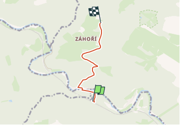
Trail On foot of 3.2 km to be discovered at Southwest, Plzeňský kraj, Ošelín. This trail is proposed by SityTrail - itinéraires balisés pédestres.
Trail created by cz:KČT.
![Trail On foot Ošelín - [Z] Ošelín - Nad Záhořím - Photo 1](https://media.geolcdn.com/t/2048/auto/8421d770-87b6-442e-b560-e14a52faa5bd.jpeg&format=jpg&maxdim=0 "Trail On foot Ošelín - [Z] Ošelín - Nad Záhořím - Photo 1")
![Trail On foot Ošelín - [Z] Ošelín - Nad Záhořím - Photo 2](https://media.geolcdn.com/t/2048/auto/5fba6980-281c-45bf-9fad-9be7bc66c012.jpeg&format=jpg&maxdim=0 "Trail On foot Ošelín - [Z] Ošelín - Nad Záhořím - Photo 2")
![Trail On foot Ošelín - [Z] Ošelín - Nad Záhořím - Photo 3](https://media.geolcdn.com/t/2048/auto/ebedcabf-e9a9-428b-ab76-521f8a452af2.jpeg&format=jpg&maxdim=0 "Trail On foot Ošelín - [Z] Ošelín - Nad Záhořím - Photo 3")
![Trail On foot Ošelín - [Z] Ošelín - Nad Záhořím - Photo 4](https://media.geolcdn.com/t/2048/auto/0c9544f1-43d3-470a-a055-e121a598f0a1.jpeg&format=jpg&maxdim=0 "Trail On foot Ošelín - [Z] Ošelín - Nad Záhořím - Photo 4")
![Trail On foot Ošelín - [Z] Ošelín - Nad Záhořím - Photo 5](https://media.geolcdn.com/t/2048/auto/9d212964-19fb-41e9-b214-63c5e818e1de.jpeg&format=jpg&maxdim=0 "Trail On foot Ošelín - [Z] Ošelín - Nad Záhořím - Photo 5")
![Trail On foot Ošelín - [Z] Ošelín - Nad Záhořím - Photo 6](https://media.geolcdn.com/t/2048/auto/e70de429-765c-4677-960f-e06d05bd04ab.jpeg&format=jpg&maxdim=0 "Trail On foot Ošelín - [Z] Ošelín - Nad Záhořím - Photo 6")
![Trail On foot Ošelín - [Z] Ošelín - Nad Záhořím - Photo 7](https://media.geolcdn.com/t/2048/auto/217c813c-b721-4764-a500-5c8e913f4457.jpeg&format=jpg&maxdim=0 "Trail On foot Ošelín - [Z] Ošelín - Nad Záhořím - Photo 7")
![Trail On foot Ošelín - [Z] Ošelín - Nad Záhořím - Photo 8](https://media.geolcdn.com/t/2048/auto/2ad0d954-8389-4614-8548-749ca6d49204.jpeg&format=jpg&maxdim=0 "Trail On foot Ošelín - [Z] Ošelín - Nad Záhořím - Photo 8")
![Trail On foot Ošelín - [Z] Ošelín - Nad Záhořím - Photo 9](https://media.geolcdn.com/t/2048/auto/e56c971f-9f1c-40e2-9ad5-f2bb48213840.jpeg&format=jpg&maxdim=0 "Trail On foot Ošelín - [Z] Ošelín - Nad Záhořím - Photo 9")
![Trail On foot Ošelín - [Z] Ošelín - Nad Záhořím - Photo 10](https://media.geolcdn.com/t/2048/auto/95d79fd7-3d70-4242-a85e-dd68c90ddf1c.jpeg&format=jpg&maxdim=0 "Trail On foot Ošelín - [Z] Ošelín - Nad Záhořím - Photo 10")
![Trail On foot Černošín - [Ž] Pod Třebelí - Volfštejn - Černošín - Krasíkov - Photo](https://media.geolcdn.com/t/375/260/42da8eaf-ff34-45f0-a1bf-8ecf2b3765a4.jpeg&format=jpg&maxdim=2)
On foot