


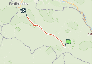

5.2 km | 10.5 km-effort
![Trail On foot Hejnice - [Ž] U Čihadel - Pod vodopády - Photo](https://media.geolcdn.com/t/1900/400/0305cc7e-1c57-4a29-952f-b53c07c6ec89.jpeg&format=pjpeg&maxdim=2)

Tous les sentiers balisés d’Europe GUIDE+


FREE GPS app for hiking
 SityTrail
IGN / Geographical institutes
SityTrail World
The world is yours!
Trail On foot of 5.1 km to be discovered at Northeast, Liberecký kraj, Hejnice. This trail is proposed by SityTrail - itinéraires balisés pédestres.
Trail created by cz:KČT.
![Trail On foot Hejnice - [Ž] U Čihadel - Pod vodopády - Photo 1](https://media.geolcdn.com/t/2048/auto/371cdae0-70cb-417c-a2e3-d83a5b6990c7.jpeg&format=jpg&maxdim=0 "Trail On foot Hejnice - [Ž] U Čihadel - Pod vodopády - Photo 1")
![Trail On foot Hejnice - [Ž] U Čihadel - Pod vodopády - Photo 2](https://media.geolcdn.com/t/2048/auto/72189e60-e046-4013-9e9f-b692baa554be.jpeg&format=jpg&maxdim=0 "Trail On foot Hejnice - [Ž] U Čihadel - Pod vodopády - Photo 2")
![Trail On foot Hejnice - [Ž] U Čihadel - Pod vodopády - Photo 3](https://media.geolcdn.com/t/2048/auto/18f4c1bc-97e3-4f83-8dfe-669327bb687d.jpeg&format=jpg&maxdim=0 "Trail On foot Hejnice - [Ž] U Čihadel - Pod vodopády - Photo 3")
![Trail On foot Hejnice - [Ž] U Čihadel - Pod vodopády - Photo 4](https://media.geolcdn.com/t/2048/auto/b1bf5e3e-6ae0-462e-8c23-d44696ba2f9e.jpeg&format=jpg&maxdim=0 "Trail On foot Hejnice - [Ž] U Čihadel - Pod vodopády - Photo 4")
![Trail On foot Hejnice - [Ž] U Čihadel - Pod vodopády - Photo 5](https://media.geolcdn.com/t/2048/auto/95718d22-af9a-4baf-b4bf-5e6b8a95ba96.jpeg&format=jpg&maxdim=0 "Trail On foot Hejnice - [Ž] U Čihadel - Pod vodopády - Photo 5")
![Trail On foot Hejnice - [Ž] U Čihadel - Pod vodopády - Photo 6](https://media.geolcdn.com/t/2048/auto/d86c0566-1bbb-4180-af93-d43d5190b4cc.jpeg&format=jpg&maxdim=0 "Trail On foot Hejnice - [Ž] U Čihadel - Pod vodopády - Photo 6")
![Trail On foot Hejnice - [Ž] U Čihadel - Pod vodopády - Photo 7](https://media.geolcdn.com/t/2048/auto/e9ea55e9-22ff-4a6b-968c-7b5419355165.jpeg&format=jpg&maxdim=0 "Trail On foot Hejnice - [Ž] U Čihadel - Pod vodopády - Photo 7")
![Trail On foot Hejnice - [Ž] U Čihadel - Pod vodopády - Photo 8](https://media.geolcdn.com/t/2048/auto/7b1d821f-517c-4fde-8256-d5efebd8204c.jpeg&format=jpg&maxdim=0 "Trail On foot Hejnice - [Ž] U Čihadel - Pod vodopády - Photo 8")
![Trail On foot Hejnice - [Ž] U Čihadel - Pod vodopády - Photo 9](https://media.geolcdn.com/t/2048/auto/5b6bfb95-cb87-4c4a-b4c0-0603ba89d33d.jpeg&format=jpg&maxdim=0 "Trail On foot Hejnice - [Ž] U Čihadel - Pod vodopády - Photo 9")
![Trail On foot Hejnice - [Ž] U Čihadel - Pod vodopády - Photo 10](https://media.geolcdn.com/t/2048/auto/0305cc7e-1c57-4a29-952f-b53c07c6ec89.jpeg&format=jpg&maxdim=0 "Trail On foot Hejnice - [Ž] U Čihadel - Pod vodopády - Photo 10")
On foot