


3.2 km | 4.4 km-effort
![Trail On foot Janov nad Nisou - [Ž] Janov n. Nisou - Oldřichov v Hájích - Photo](https://media.geolcdn.com/t/1900/400/703658ce-3bf0-4cef-be8c-c91c5882d2e3.jpeg&format=pjpeg&maxdim=2)

Tous les sentiers balisés d’Europe GUIDE+


FREE GPS app for hiking
 SityTrail
IGN / Geographical institutes
SityTrail World
The world is yours!
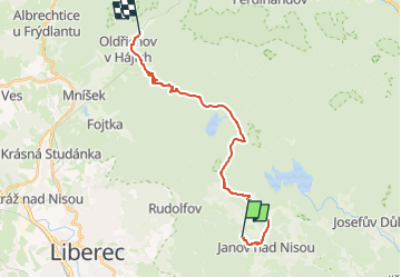
Trail On foot of 17.3 km to be discovered at Northeast, Liberecký kraj, Janov nad Nisou. This trail is proposed by SityTrail - itinéraires balisés pédestres.
Trail created by cz:KČT.
![Trail On foot Janov nad Nisou - [Ž] Janov n. Nisou - Oldřichov v Hájích - Photo 1](https://media.geolcdn.com/t/2048/auto/616907d4-7a0c-42e3-ad86-6e36b753e01e.jpeg&format=jpg&maxdim=0 "Trail On foot Janov nad Nisou - [Ž] Janov n. Nisou - Oldřichov v Hájích - Photo 1")
![Trail On foot Janov nad Nisou - [Ž] Janov n. Nisou - Oldřichov v Hájích - Photo 2](https://media.geolcdn.com/t/2048/auto/7b7cc992-b33a-4509-9c3e-737945618c46.jpeg&format=jpg&maxdim=0 "Trail On foot Janov nad Nisou - [Ž] Janov n. Nisou - Oldřichov v Hájích - Photo 2")
![Trail On foot Janov nad Nisou - [Ž] Janov n. Nisou - Oldřichov v Hájích - Photo 3](https://media.geolcdn.com/t/2048/auto/4dcb4f81-19e9-4037-aa62-f836ac2b4908.jpeg&format=jpg&maxdim=0 "Trail On foot Janov nad Nisou - [Ž] Janov n. Nisou - Oldřichov v Hájích - Photo 3")
![Trail On foot Janov nad Nisou - [Ž] Janov n. Nisou - Oldřichov v Hájích - Photo 4](https://media.geolcdn.com/t/2048/auto/81894a09-c862-42f2-946d-5459bdb99f4c.jpeg&format=jpg&maxdim=0 "Trail On foot Janov nad Nisou - [Ž] Janov n. Nisou - Oldřichov v Hájích - Photo 4")
![Trail On foot Janov nad Nisou - [Ž] Janov n. Nisou - Oldřichov v Hájích - Photo 5](https://media.geolcdn.com/t/2048/auto/cedc5279-c375-4fa5-b5dc-c7add5997e49.jpeg&format=jpg&maxdim=0 "Trail On foot Janov nad Nisou - [Ž] Janov n. Nisou - Oldřichov v Hájích - Photo 5")
![Trail On foot Janov nad Nisou - [Ž] Janov n. Nisou - Oldřichov v Hájích - Photo 6](https://media.geolcdn.com/t/2048/auto/f7234f16-e329-4152-a38c-a6711831c0b1.jpeg&format=jpg&maxdim=0 "Trail On foot Janov nad Nisou - [Ž] Janov n. Nisou - Oldřichov v Hájích - Photo 6")
![Trail On foot Janov nad Nisou - [Ž] Janov n. Nisou - Oldřichov v Hájích - Photo 7](https://media.geolcdn.com/t/2048/auto/fdc332f4-437b-4e99-a1f4-5424bfb75298.jpeg&format=jpg&maxdim=0 "Trail On foot Janov nad Nisou - [Ž] Janov n. Nisou - Oldřichov v Hájích - Photo 7")
![Trail On foot Janov nad Nisou - [Ž] Janov n. Nisou - Oldřichov v Hájích - Photo 8](https://media.geolcdn.com/t/2048/auto/50ef103e-2b7a-4146-9b67-97c0aaa8ce8d.jpeg&format=jpg&maxdim=0 "Trail On foot Janov nad Nisou - [Ž] Janov n. Nisou - Oldřichov v Hájích - Photo 8")
![Trail On foot Janov nad Nisou - [Ž] Janov n. Nisou - Oldřichov v Hájích - Photo 9](https://media.geolcdn.com/t/2048/auto/ef2401fb-3f4c-4c77-bcce-561bd00fad53.jpeg&format=jpg&maxdim=0 "Trail On foot Janov nad Nisou - [Ž] Janov n. Nisou - Oldřichov v Hájích - Photo 9")
![Trail On foot Janov nad Nisou - [Ž] Janov n. Nisou - Oldřichov v Hájích - Photo 10](https://media.geolcdn.com/t/2048/auto/703658ce-3bf0-4cef-be8c-c91c5882d2e3.jpeg&format=jpg&maxdim=0 "Trail On foot Janov nad Nisou - [Ž] Janov n. Nisou - Oldřichov v Hájích - Photo 10")
On foot
![Trail On foot Bedřichov - [M] Stammelův kříž - U Knejpy - Photo](https://media.geolcdn.com/t/375/260/774a6f0d-e5e9-4254-87f2-9fca012b871e.jpeg&format=jpg&maxdim=2)
On foot