


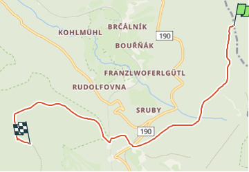

8.3 km | 12 km-effort
![Trail On foot Čachrov - [M] Pod Malým Špičákem - Habr - Photo](https://media.geolcdn.com/t/1900/400/6d63f79d-11cc-4587-9739-9e93615a4eec.jpeg&format=pjpeg&maxdim=2)

Tous les sentiers balisés d’Europe GUIDE+


FREE GPS app for hiking
 SityTrail
IGN / Geographical institutes
SityTrail World
The world is yours!
Trail On foot of 6.7 km to be discovered at Southwest, Plzeňský kraj, Čachrov. This trail is proposed by SityTrail - itinéraires balisés pédestres.
Trail created by cz:KČT.
![Trail On foot Čachrov - [M] Pod Malým Špičákem - Habr - Photo 1](https://media.geolcdn.com/t/2048/auto/57eb5810-38e6-4f5b-830a-b1c588056528.jpeg&format=jpg&maxdim=0 "Trail On foot Čachrov - [M] Pod Malým Špičákem - Habr - Photo 1")
![Trail On foot Čachrov - [M] Pod Malým Špičákem - Habr - Photo 2](https://media.geolcdn.com/t/2048/auto/07f27202-2c71-4e7f-aadb-9923d244c024.jpeg&format=jpg&maxdim=0 "Trail On foot Čachrov - [M] Pod Malým Špičákem - Habr - Photo 2")
![Trail On foot Čachrov - [M] Pod Malým Špičákem - Habr - Photo 3](https://media.geolcdn.com/t/2048/auto/2ed5ce56-1a8d-407d-aa48-1898f468df31.jpeg&format=jpg&maxdim=0 "Trail On foot Čachrov - [M] Pod Malým Špičákem - Habr - Photo 3")
![Trail On foot Čachrov - [M] Pod Malým Špičákem - Habr - Photo 4](https://media.geolcdn.com/t/2048/auto/fb9fafc5-127c-40de-84fa-0edbc33c3263.jpeg&format=jpg&maxdim=0 "Trail On foot Čachrov - [M] Pod Malým Špičákem - Habr - Photo 4")
![Trail On foot Čachrov - [M] Pod Malým Špičákem - Habr - Photo 5](https://media.geolcdn.com/t/2048/auto/18027e65-e2ff-45cd-aacf-e17a8d51a396.jpeg&format=jpg&maxdim=0 "Trail On foot Čachrov - [M] Pod Malým Špičákem - Habr - Photo 5")
![Trail On foot Čachrov - [M] Pod Malým Špičákem - Habr - Photo 6](https://media.geolcdn.com/t/2048/auto/18c49383-1e1e-4e0a-b10a-1778de9e4c1f.jpeg&format=jpg&maxdim=0 "Trail On foot Čachrov - [M] Pod Malým Špičákem - Habr - Photo 6")
![Trail On foot Čachrov - [M] Pod Malým Špičákem - Habr - Photo 7](https://media.geolcdn.com/t/2048/auto/7c6c5567-8b20-49c8-b34a-532900aa60df.jpeg&format=jpg&maxdim=0 "Trail On foot Čachrov - [M] Pod Malým Špičákem - Habr - Photo 7")
![Trail On foot Čachrov - [M] Pod Malým Špičákem - Habr - Photo 8](https://media.geolcdn.com/t/2048/auto/0c7134a3-e33f-48a7-8c6e-c911679bf6f2.jpeg&format=jpg&maxdim=0 "Trail On foot Čachrov - [M] Pod Malým Špičákem - Habr - Photo 8")
![Trail On foot Čachrov - [M] Pod Malým Špičákem - Habr - Photo 9](https://media.geolcdn.com/t/2048/auto/6d63f79d-11cc-4587-9739-9e93615a4eec.jpeg&format=jpg&maxdim=0 "Trail On foot Čachrov - [M] Pod Malým Špičákem - Habr - Photo 9")
![Trail On foot Čachrov - [M] Pod Malým Špičákem - Habr - Photo 10](https://media.geolcdn.com/t/2048/auto/644b9316-cf3f-44eb-9303-f859ab38a8b5.jpeg&format=jpg&maxdim=0 "Trail On foot Čachrov - [M] Pod Malým Špičákem - Habr - Photo 10")
On foot
On foot