![](/images/other/stat-length.png)
![Trail On foot District of Košice II - Náučný chodník Mestskej časti Košice - Sídlisko KVP - Photo](https://media.geolcdn.com/t/1900/400/275c3362-bcc2-4b48-8df5-d095606e5538.jpeg&format=pjpeg&maxdim=2)
Náučný chodník Mestskej časti Košice - Sídlisko KVP
SityTrail - itinéraires balisés pédestres
Tous les sentiers balisés d’Europe GUIDE+
![Length](/images/other/stat-length.png)
Length
3 km
![Max alt](https://static1.geolcdn.com/siteimages/upload/files/1508320355ic_sort_altitude_max_24dp.png)
Max alt
326 m
![Uphill gradient](https://static1.geolcdn.com/siteimages/upload/files/1508320355ic_sort_den_pos_24dp.png)
Uphill gradient
66 m
![Km-Effort](/images/other/stat-length.png)
Km-Effort
3.8 km
![Min alt](https://static1.geolcdn.com/siteimages/upload/files/1508320355ic_sort_altitude_min_24dp.png)
Min alt
273 m
![Downhill gradient](https://static1.geolcdn.com/siteimages/upload/files/1508320355ic_sort_den_neg_24dp.png)
Downhill gradient
19 m
![Boucle](https://static1.geolcdn.com/siteimages/upload/files/16400158638029165_repeat_loop_refresh_sync_direction_icon.png)
Boucle
No
Signpost
Creation date :
2025-02-06 14:53:18.761
Updated on :
2025-02-06 14:53:18.761
![On foot](https://static1.geolcdn.com/sitytour/trail-icons/100.png)
51m
Difficulty : Easy
![Scan this QR Code to open this trail in the SityTrail application](https://capi.geolives.com/qq0zvz2zws4bq2lad0pu/sitytour/trails/4343263/qr.png?size=200)
FREE GPS app for hiking
About
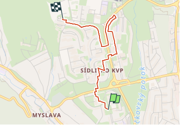
Trail On foot of 3 km to be discovered at Region of Košice, Košice, District of Košice II. This trail is proposed by SityTrail - itinéraires balisés pédestres.
Description
Trail created by Miestny úrad KVP.
no symbols, map depicted on boards is very inaccurate, some board positions are completely off, this relation is best effort to connect all boards in the order intended
Positioning
Country:
Slovakia
Region :
Region of Košice
Department/Province :
Košice
Municipality :
District of Košice II
Location:
Košice - mestská časť Sídlisko KVP
Start:(Dec)
Start:(UTM)
515787 ; 5395178 (34U) N.
Comments
Trails nearby
![Trail On foot District of Košice I - Vrabčie skaly - Photo](https://media.geolcdn.com/t/375/260/7451ea83-a1e3-4ace-a0e3-957f0ef3aa62.jpeg&format=jpg&maxdim=2)
![On foot On foot](https://static1.geolcdn.com/sitytour/trail-icons/100.png)
Vrabčie skaly
On foot
Easy
District of Košice I,
Region of Košice,
Košice,
Slovakia
![](/images/other/stat-length.png)
4.9 km | 7.7 km-effort
1h 44min
![](https://static1.geolcdn.com/siteimages/upload/files/16400158638029165_repeat_loop_refresh_sync_direction_icon.png)
Yes