


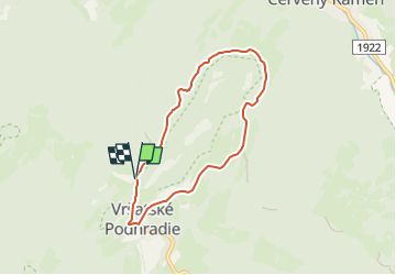

8.2 km | 11.2 km-effort

Tous les sentiers balisés d’Europe GUIDE+


FREE GPS app for hiking
 SityTrail
IGN / Geographical institutes
SityTrail World
The world is yours!
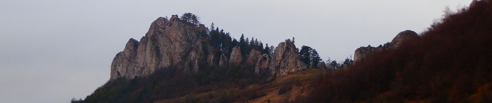
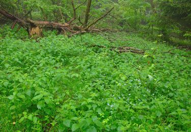
Trail On foot of 5.9 km to be discovered at Region of Trenčín, Unknown, District of Ilava. This trail is proposed by SityTrail - itinéraires balisés pédestres.
Symbol: education
 "
data-pinterest-text="Pin it"
data-tweet-text="share on twitter"
data-facebook-share-url="https://www.sitytrail.com/en/trails/4343043-district-of-ilava--naucny-chodnik-xokolo-vrsatca-x-koruny-bielych-karpatx/?photo=1#lg=1&slide=1"
data-twitter-share-url="https://www.sitytrail.com/en/trails/4343043-district-of-ilava--naucny-chodnik-xokolo-vrsatca-x-koruny-bielych-karpatx/?photo=1#lg=1&slide=1"
data-googleplus-share-url="https://www.sitytrail.com/en/trails/4343043-district-of-ilava--naucny-chodnik-xokolo-vrsatca-x-koruny-bielych-karpatx/?photo=1#lg=1&slide=1"
data-pinterest-share-url="https://www.sitytrail.com/en/trails/4343043-district-of-ilava--naucny-chodnik-xokolo-vrsatca-x-koruny-bielych-karpatx/?photo=1#lg=1&slide=1">
"
data-pinterest-text="Pin it"
data-tweet-text="share on twitter"
data-facebook-share-url="https://www.sitytrail.com/en/trails/4343043-district-of-ilava--naucny-chodnik-xokolo-vrsatca-x-koruny-bielych-karpatx/?photo=1#lg=1&slide=1"
data-twitter-share-url="https://www.sitytrail.com/en/trails/4343043-district-of-ilava--naucny-chodnik-xokolo-vrsatca-x-koruny-bielych-karpatx/?photo=1#lg=1&slide=1"
data-googleplus-share-url="https://www.sitytrail.com/en/trails/4343043-district-of-ilava--naucny-chodnik-xokolo-vrsatca-x-koruny-bielych-karpatx/?photo=1#lg=1&slide=1"
data-pinterest-share-url="https://www.sitytrail.com/en/trails/4343043-district-of-ilava--naucny-chodnik-xokolo-vrsatca-x-koruny-bielych-karpatx/?photo=1#lg=1&slide=1">
 "
data-pinterest-text="Pin it"
data-tweet-text="share on twitter"
data-facebook-share-url="https://www.sitytrail.com/en/trails/4343043-district-of-ilava--naucny-chodnik-xokolo-vrsatca-x-koruny-bielych-karpatx/?photo=2#lg=1&slide=2"
data-twitter-share-url="https://www.sitytrail.com/en/trails/4343043-district-of-ilava--naucny-chodnik-xokolo-vrsatca-x-koruny-bielych-karpatx/?photo=2#lg=1&slide=2"
data-googleplus-share-url="https://www.sitytrail.com/en/trails/4343043-district-of-ilava--naucny-chodnik-xokolo-vrsatca-x-koruny-bielych-karpatx/?photo=2#lg=1&slide=2"
data-pinterest-share-url="https://www.sitytrail.com/en/trails/4343043-district-of-ilava--naucny-chodnik-xokolo-vrsatca-x-koruny-bielych-karpatx/?photo=2#lg=1&slide=2">
"
data-pinterest-text="Pin it"
data-tweet-text="share on twitter"
data-facebook-share-url="https://www.sitytrail.com/en/trails/4343043-district-of-ilava--naucny-chodnik-xokolo-vrsatca-x-koruny-bielych-karpatx/?photo=2#lg=1&slide=2"
data-twitter-share-url="https://www.sitytrail.com/en/trails/4343043-district-of-ilava--naucny-chodnik-xokolo-vrsatca-x-koruny-bielych-karpatx/?photo=2#lg=1&slide=2"
data-googleplus-share-url="https://www.sitytrail.com/en/trails/4343043-district-of-ilava--naucny-chodnik-xokolo-vrsatca-x-koruny-bielych-karpatx/?photo=2#lg=1&slide=2"
data-pinterest-share-url="https://www.sitytrail.com/en/trails/4343043-district-of-ilava--naucny-chodnik-xokolo-vrsatca-x-koruny-bielych-karpatx/?photo=2#lg=1&slide=2">
 "
data-pinterest-text="Pin it"
data-tweet-text="share on twitter"
data-facebook-share-url="https://www.sitytrail.com/en/trails/4343043-district-of-ilava--naucny-chodnik-xokolo-vrsatca-x-koruny-bielych-karpatx/?photo=3#lg=1&slide=3"
data-twitter-share-url="https://www.sitytrail.com/en/trails/4343043-district-of-ilava--naucny-chodnik-xokolo-vrsatca-x-koruny-bielych-karpatx/?photo=3#lg=1&slide=3"
data-googleplus-share-url="https://www.sitytrail.com/en/trails/4343043-district-of-ilava--naucny-chodnik-xokolo-vrsatca-x-koruny-bielych-karpatx/?photo=3#lg=1&slide=3"
data-pinterest-share-url="https://www.sitytrail.com/en/trails/4343043-district-of-ilava--naucny-chodnik-xokolo-vrsatca-x-koruny-bielych-karpatx/?photo=3#lg=1&slide=3">
"
data-pinterest-text="Pin it"
data-tweet-text="share on twitter"
data-facebook-share-url="https://www.sitytrail.com/en/trails/4343043-district-of-ilava--naucny-chodnik-xokolo-vrsatca-x-koruny-bielych-karpatx/?photo=3#lg=1&slide=3"
data-twitter-share-url="https://www.sitytrail.com/en/trails/4343043-district-of-ilava--naucny-chodnik-xokolo-vrsatca-x-koruny-bielych-karpatx/?photo=3#lg=1&slide=3"
data-googleplus-share-url="https://www.sitytrail.com/en/trails/4343043-district-of-ilava--naucny-chodnik-xokolo-vrsatca-x-koruny-bielych-karpatx/?photo=3#lg=1&slide=3"
data-pinterest-share-url="https://www.sitytrail.com/en/trails/4343043-district-of-ilava--naucny-chodnik-xokolo-vrsatca-x-koruny-bielych-karpatx/?photo=3#lg=1&slide=3">
 "
data-pinterest-text="Pin it"
data-tweet-text="share on twitter"
data-facebook-share-url="https://www.sitytrail.com/en/trails/4343043-district-of-ilava--naucny-chodnik-xokolo-vrsatca-x-koruny-bielych-karpatx/?photo=4#lg=1&slide=4"
data-twitter-share-url="https://www.sitytrail.com/en/trails/4343043-district-of-ilava--naucny-chodnik-xokolo-vrsatca-x-koruny-bielych-karpatx/?photo=4#lg=1&slide=4"
data-googleplus-share-url="https://www.sitytrail.com/en/trails/4343043-district-of-ilava--naucny-chodnik-xokolo-vrsatca-x-koruny-bielych-karpatx/?photo=4#lg=1&slide=4"
data-pinterest-share-url="https://www.sitytrail.com/en/trails/4343043-district-of-ilava--naucny-chodnik-xokolo-vrsatca-x-koruny-bielych-karpatx/?photo=4#lg=1&slide=4">
"
data-pinterest-text="Pin it"
data-tweet-text="share on twitter"
data-facebook-share-url="https://www.sitytrail.com/en/trails/4343043-district-of-ilava--naucny-chodnik-xokolo-vrsatca-x-koruny-bielych-karpatx/?photo=4#lg=1&slide=4"
data-twitter-share-url="https://www.sitytrail.com/en/trails/4343043-district-of-ilava--naucny-chodnik-xokolo-vrsatca-x-koruny-bielych-karpatx/?photo=4#lg=1&slide=4"
data-googleplus-share-url="https://www.sitytrail.com/en/trails/4343043-district-of-ilava--naucny-chodnik-xokolo-vrsatca-x-koruny-bielych-karpatx/?photo=4#lg=1&slide=4"
data-pinterest-share-url="https://www.sitytrail.com/en/trails/4343043-district-of-ilava--naucny-chodnik-xokolo-vrsatca-x-koruny-bielych-karpatx/?photo=4#lg=1&slide=4">
 "
data-pinterest-text="Pin it"
data-tweet-text="share on twitter"
data-facebook-share-url="https://www.sitytrail.com/en/trails/4343043-district-of-ilava--naucny-chodnik-xokolo-vrsatca-x-koruny-bielych-karpatx/?photo=5#lg=1&slide=5"
data-twitter-share-url="https://www.sitytrail.com/en/trails/4343043-district-of-ilava--naucny-chodnik-xokolo-vrsatca-x-koruny-bielych-karpatx/?photo=5#lg=1&slide=5"
data-googleplus-share-url="https://www.sitytrail.com/en/trails/4343043-district-of-ilava--naucny-chodnik-xokolo-vrsatca-x-koruny-bielych-karpatx/?photo=5#lg=1&slide=5"
data-pinterest-share-url="https://www.sitytrail.com/en/trails/4343043-district-of-ilava--naucny-chodnik-xokolo-vrsatca-x-koruny-bielych-karpatx/?photo=5#lg=1&slide=5">
"
data-pinterest-text="Pin it"
data-tweet-text="share on twitter"
data-facebook-share-url="https://www.sitytrail.com/en/trails/4343043-district-of-ilava--naucny-chodnik-xokolo-vrsatca-x-koruny-bielych-karpatx/?photo=5#lg=1&slide=5"
data-twitter-share-url="https://www.sitytrail.com/en/trails/4343043-district-of-ilava--naucny-chodnik-xokolo-vrsatca-x-koruny-bielych-karpatx/?photo=5#lg=1&slide=5"
data-googleplus-share-url="https://www.sitytrail.com/en/trails/4343043-district-of-ilava--naucny-chodnik-xokolo-vrsatca-x-koruny-bielych-karpatx/?photo=5#lg=1&slide=5"
data-pinterest-share-url="https://www.sitytrail.com/en/trails/4343043-district-of-ilava--naucny-chodnik-xokolo-vrsatca-x-koruny-bielych-karpatx/?photo=5#lg=1&slide=5">
 "
data-pinterest-text="Pin it"
data-tweet-text="share on twitter"
data-facebook-share-url="https://www.sitytrail.com/en/trails/4343043-district-of-ilava--naucny-chodnik-xokolo-vrsatca-x-koruny-bielych-karpatx/?photo=6#lg=1&slide=6"
data-twitter-share-url="https://www.sitytrail.com/en/trails/4343043-district-of-ilava--naucny-chodnik-xokolo-vrsatca-x-koruny-bielych-karpatx/?photo=6#lg=1&slide=6"
data-googleplus-share-url="https://www.sitytrail.com/en/trails/4343043-district-of-ilava--naucny-chodnik-xokolo-vrsatca-x-koruny-bielych-karpatx/?photo=6#lg=1&slide=6"
data-pinterest-share-url="https://www.sitytrail.com/en/trails/4343043-district-of-ilava--naucny-chodnik-xokolo-vrsatca-x-koruny-bielych-karpatx/?photo=6#lg=1&slide=6">
"
data-pinterest-text="Pin it"
data-tweet-text="share on twitter"
data-facebook-share-url="https://www.sitytrail.com/en/trails/4343043-district-of-ilava--naucny-chodnik-xokolo-vrsatca-x-koruny-bielych-karpatx/?photo=6#lg=1&slide=6"
data-twitter-share-url="https://www.sitytrail.com/en/trails/4343043-district-of-ilava--naucny-chodnik-xokolo-vrsatca-x-koruny-bielych-karpatx/?photo=6#lg=1&slide=6"
data-googleplus-share-url="https://www.sitytrail.com/en/trails/4343043-district-of-ilava--naucny-chodnik-xokolo-vrsatca-x-koruny-bielych-karpatx/?photo=6#lg=1&slide=6"
data-pinterest-share-url="https://www.sitytrail.com/en/trails/4343043-district-of-ilava--naucny-chodnik-xokolo-vrsatca-x-koruny-bielych-karpatx/?photo=6#lg=1&slide=6">
 "
data-pinterest-text="Pin it"
data-tweet-text="share on twitter"
data-facebook-share-url="https://www.sitytrail.com/en/trails/4343043-district-of-ilava--naucny-chodnik-xokolo-vrsatca-x-koruny-bielych-karpatx/?photo=7#lg=1&slide=7"
data-twitter-share-url="https://www.sitytrail.com/en/trails/4343043-district-of-ilava--naucny-chodnik-xokolo-vrsatca-x-koruny-bielych-karpatx/?photo=7#lg=1&slide=7"
data-googleplus-share-url="https://www.sitytrail.com/en/trails/4343043-district-of-ilava--naucny-chodnik-xokolo-vrsatca-x-koruny-bielych-karpatx/?photo=7#lg=1&slide=7"
data-pinterest-share-url="https://www.sitytrail.com/en/trails/4343043-district-of-ilava--naucny-chodnik-xokolo-vrsatca-x-koruny-bielych-karpatx/?photo=7#lg=1&slide=7">
"
data-pinterest-text="Pin it"
data-tweet-text="share on twitter"
data-facebook-share-url="https://www.sitytrail.com/en/trails/4343043-district-of-ilava--naucny-chodnik-xokolo-vrsatca-x-koruny-bielych-karpatx/?photo=7#lg=1&slide=7"
data-twitter-share-url="https://www.sitytrail.com/en/trails/4343043-district-of-ilava--naucny-chodnik-xokolo-vrsatca-x-koruny-bielych-karpatx/?photo=7#lg=1&slide=7"
data-googleplus-share-url="https://www.sitytrail.com/en/trails/4343043-district-of-ilava--naucny-chodnik-xokolo-vrsatca-x-koruny-bielych-karpatx/?photo=7#lg=1&slide=7"
data-pinterest-share-url="https://www.sitytrail.com/en/trails/4343043-district-of-ilava--naucny-chodnik-xokolo-vrsatca-x-koruny-bielych-karpatx/?photo=7#lg=1&slide=7">
 "
data-pinterest-text="Pin it"
data-tweet-text="share on twitter"
data-facebook-share-url="https://www.sitytrail.com/en/trails/4343043-district-of-ilava--naucny-chodnik-xokolo-vrsatca-x-koruny-bielych-karpatx/?photo=8#lg=1&slide=8"
data-twitter-share-url="https://www.sitytrail.com/en/trails/4343043-district-of-ilava--naucny-chodnik-xokolo-vrsatca-x-koruny-bielych-karpatx/?photo=8#lg=1&slide=8"
data-googleplus-share-url="https://www.sitytrail.com/en/trails/4343043-district-of-ilava--naucny-chodnik-xokolo-vrsatca-x-koruny-bielych-karpatx/?photo=8#lg=1&slide=8"
data-pinterest-share-url="https://www.sitytrail.com/en/trails/4343043-district-of-ilava--naucny-chodnik-xokolo-vrsatca-x-koruny-bielych-karpatx/?photo=8#lg=1&slide=8">
"
data-pinterest-text="Pin it"
data-tweet-text="share on twitter"
data-facebook-share-url="https://www.sitytrail.com/en/trails/4343043-district-of-ilava--naucny-chodnik-xokolo-vrsatca-x-koruny-bielych-karpatx/?photo=8#lg=1&slide=8"
data-twitter-share-url="https://www.sitytrail.com/en/trails/4343043-district-of-ilava--naucny-chodnik-xokolo-vrsatca-x-koruny-bielych-karpatx/?photo=8#lg=1&slide=8"
data-googleplus-share-url="https://www.sitytrail.com/en/trails/4343043-district-of-ilava--naucny-chodnik-xokolo-vrsatca-x-koruny-bielych-karpatx/?photo=8#lg=1&slide=8"
data-pinterest-share-url="https://www.sitytrail.com/en/trails/4343043-district-of-ilava--naucny-chodnik-xokolo-vrsatca-x-koruny-bielych-karpatx/?photo=8#lg=1&slide=8">
 "
data-pinterest-text="Pin it"
data-tweet-text="share on twitter"
data-facebook-share-url="https://www.sitytrail.com/en/trails/4343043-district-of-ilava--naucny-chodnik-xokolo-vrsatca-x-koruny-bielych-karpatx/?photo=9#lg=1&slide=9"
data-twitter-share-url="https://www.sitytrail.com/en/trails/4343043-district-of-ilava--naucny-chodnik-xokolo-vrsatca-x-koruny-bielych-karpatx/?photo=9#lg=1&slide=9"
data-googleplus-share-url="https://www.sitytrail.com/en/trails/4343043-district-of-ilava--naucny-chodnik-xokolo-vrsatca-x-koruny-bielych-karpatx/?photo=9#lg=1&slide=9"
data-pinterest-share-url="https://www.sitytrail.com/en/trails/4343043-district-of-ilava--naucny-chodnik-xokolo-vrsatca-x-koruny-bielych-karpatx/?photo=9#lg=1&slide=9">
"
data-pinterest-text="Pin it"
data-tweet-text="share on twitter"
data-facebook-share-url="https://www.sitytrail.com/en/trails/4343043-district-of-ilava--naucny-chodnik-xokolo-vrsatca-x-koruny-bielych-karpatx/?photo=9#lg=1&slide=9"
data-twitter-share-url="https://www.sitytrail.com/en/trails/4343043-district-of-ilava--naucny-chodnik-xokolo-vrsatca-x-koruny-bielych-karpatx/?photo=9#lg=1&slide=9"
data-googleplus-share-url="https://www.sitytrail.com/en/trails/4343043-district-of-ilava--naucny-chodnik-xokolo-vrsatca-x-koruny-bielych-karpatx/?photo=9#lg=1&slide=9"
data-pinterest-share-url="https://www.sitytrail.com/en/trails/4343043-district-of-ilava--naucny-chodnik-xokolo-vrsatca-x-koruny-bielych-karpatx/?photo=9#lg=1&slide=9">

On foot