![](/images/other/stat-length.png)
![Trail Walking Utelle - Col d’Ambellarte - Photo](https://media.geolcdn.com/t/1900/400/ext.pjpeg?maxdim=2&url=https%3A%2F%2Fstatic1.geolcdn.com%2Fsiteimages%2Fupload%2Ffiles%2F1553511878bg_sport_marche.png)
Col d’Ambellarte
bozo1970
User
![Length](/images/other/stat-length.png)
Length
11.6 km
![Max alt](https://static1.geolcdn.com/siteimages/upload/files/1508320355ic_sort_altitude_max_24dp.png)
Max alt
1040 m
![Uphill gradient](https://static1.geolcdn.com/siteimages/upload/files/1508320355ic_sort_den_pos_24dp.png)
Uphill gradient
770 m
![Km-Effort](/images/other/stat-length.png)
Km-Effort
22 km
![Min alt](https://static1.geolcdn.com/siteimages/upload/files/1508320355ic_sort_altitude_min_24dp.png)
Min alt
329 m
![Downhill gradient](https://static1.geolcdn.com/siteimages/upload/files/1508320355ic_sort_den_neg_24dp.png)
Downhill gradient
769 m
![Boucle](https://static1.geolcdn.com/siteimages/upload/files/16400158638029165_repeat_loop_refresh_sync_direction_icon.png)
Boucle
Yes
Creation date :
2025-02-06 07:43:12.0
Updated on :
2025-02-06 20:39:52.439
![Walking](https://static1.geolcdn.com/sitytour/trail-icons/101.png)
4h26
Difficulty : Medium
![Scan this QR Code to open this trail in the SityTrail application](https://capi.geolives.com/qq0zvz2zws4bq2lad0pu/sitytour/trails/4342840/qr.png?size=200)
FREE GPS app for hiking
About
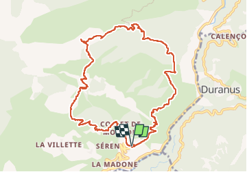
Trail Walking of 11.6 km to be discovered at Provence-Alpes-Côte d'Azur, Maritime Alps, Utelle. This trail is proposed by bozo1970.
Description
Départ de l’Eglise du Cros d’Utelle
Montée par le GR 5 jusqu’à la balise 6
Direction le col d’Ambellarte en 2h15’ 7km et D 700m
Descente par le Collet de la Signora
Guarda Villa et le Collet des Moutons
Boucle en 4h D 772 et 11km800
Première grosse sortie pour Véga
Positioning
Country:
France
Region :
Provence-Alpes-Côte d'Azur
Department/Province :
Maritime Alps
Municipality :
Utelle
Location:
Unknown
Start:(Dec)
Start:(UTM)
358344 ; 4860432 (32T) N.
Comments
Trails nearby
![Trail Walking Utelle - Le Chaudan Madone Utelle réel - Photo](https://media.geolcdn.com/t/375/260/a8253f62-eac0-40e2-8956-546eb9ade295.jpg&format=jpg&maxdim=2)
![Walking Walking](https://static1.geolcdn.com/sitytour/trail-icons/101.png)
Le Chaudan Madone Utelle réel
Walking
Very difficult
Utelle,
Provence-Alpes-Côte d'Azur,
Maritime Alps,
France
![](/images/other/stat-length.png)
19.6 km | 37 km-effort
5h 55min
![](https://static1.geolcdn.com/siteimages/upload/files/16400158638029165_repeat_loop_refresh_sync_direction_icon.png)
Yes
![Trail Walking Utelle - Le Brec d'Utelle 1604m 19-04-22 - Photo](https://media.geolcdn.com/t/375/260/f3263017-78d2-4ab0-b769-f83aa3feee5d.jpg&format=jpg&maxdim=2)
![Walking Walking](https://static1.geolcdn.com/sitytour/trail-icons/101.png)
Le Brec d'Utelle 1604m 19-04-22
Walking
Medium
Utelle,
Provence-Alpes-Côte d'Azur,
Maritime Alps,
France
![](/images/other/stat-length.png)
11.2 km | 22 km-effort
4h 15min
![](https://static1.geolcdn.com/siteimages/upload/files/16400158638029165_repeat_loop_refresh_sync_direction_icon.png)
Yes
![Trail On foot Coaraze - Rocca Sparvièra - Photo](https://media.geolcdn.com/t/375/260/b70c2ec2-277e-4b66-a927-a7ae11b9ea3a.jpeg&format=jpg&maxdim=2)
![On foot On foot](https://static1.geolcdn.com/sitytour/trail-icons/100.png)
Rocca Sparvièra
On foot
Easy
Coaraze,
Provence-Alpes-Côte d'Azur,
Maritime Alps,
France
![](/images/other/stat-length.png)
10.5 km | 17.6 km-effort
3h 59min
![](https://static1.geolcdn.com/siteimages/upload/files/16400158638029165_repeat_loop_refresh_sync_direction_icon.png)
Yes
![Trail On foot Utelle - Gorges de la Vésubie - Photo](https://media.geolcdn.com/t/375/260/0a667b03-3170-487d-a7f5-45b846bd9fdf.jpeg&format=jpg&maxdim=2)
![On foot On foot](https://static1.geolcdn.com/sitytour/trail-icons/100.png)
Gorges de la Vésubie
On foot
Medium
(1)
Utelle,
Provence-Alpes-Côte d'Azur,
Maritime Alps,
France
![](/images/other/stat-length.png)
14.6 km | 27 km-effort
6h 11min
![](https://static1.geolcdn.com/siteimages/upload/files/16400158638029165_repeat_loop_refresh_sync_direction_icon.png)
Yes
![Trail On foot Utelle - Madone d'Utelle - Photo](https://media.geolcdn.com/t/375/260/186d666d-a9cf-4d78-b5ea-394e8ee2a1a9.jpeg&format=jpg&maxdim=2)
![On foot On foot](https://static1.geolcdn.com/sitytour/trail-icons/100.png)
Madone d'Utelle
On foot
Easy
Utelle,
Provence-Alpes-Côte d'Azur,
Maritime Alps,
France
![](/images/other/stat-length.png)
9.9 km | 19.4 km-effort
4h 24min
![](https://static1.geolcdn.com/siteimages/upload/files/16400158638029165_repeat_loop_refresh_sync_direction_icon.png)
Yes
![Trail Walking Coaraze - Rocca Spavierra - Photo](https://media.geolcdn.com/t/375/260/ext.jpg?maxdim=2&url=https%3A%2F%2Fstatic1.geolcdn.com%2Fsiteimages%2Fupload%2Ffiles%2F1553511878bg_sport_marche.png)
![Walking Walking](https://static1.geolcdn.com/sitytour/trail-icons/101.png)
Rocca Spavierra
Walking
Medium
(1)
Coaraze,
Provence-Alpes-Côte d'Azur,
Maritime Alps,
France
![](/images/other/stat-length.png)
11.6 km | 19.6 km-effort
4h 6min
![](https://static1.geolcdn.com/siteimages/upload/files/16400158638029165_repeat_loop_refresh_sync_direction_icon.png)
Yes
![Trail Walking Levens - Hike 2017 jour 1 - Photo](https://media.geolcdn.com/t/375/260/ext.jpg?maxdim=2&url=https%3A%2F%2Fstatic1.geolcdn.com%2Fsiteimages%2Fupload%2Ffiles%2F1553511878bg_sport_marche.png)
![Walking Walking](https://static1.geolcdn.com/sitytour/trail-icons/101.png)
Hike 2017 jour 1
Walking
Very difficult
(1)
Levens,
Provence-Alpes-Côte d'Azur,
Maritime Alps,
France
![](/images/other/stat-length.png)
14.7 km | 29 km-effort
6h 27min
![](https://static1.geolcdn.com/siteimages/upload/files/16400158638029165_repeat_loop_refresh_sync_direction_icon.png)
No
![Trail Walking Bonson - Plan du Var-Tourrette du Château - Photo](https://media.geolcdn.com/t/375/260/b4642ae4-5db0-433c-a2e5-2905ecab06e6.jpg&format=jpg&maxdim=2)
![Walking Walking](https://static1.geolcdn.com/sitytour/trail-icons/101.png)
Plan du Var-Tourrette du Château
Walking
Difficult
Bonson,
Provence-Alpes-Côte d'Azur,
Maritime Alps,
France
![](/images/other/stat-length.png)
19.1 km | 35 km-effort
7h 50min
![](https://static1.geolcdn.com/siteimages/upload/files/16400158638029165_repeat_loop_refresh_sync_direction_icon.png)
Yes
![Trail Walking Utelle - Cros d Utelle chapelle St Antoine - Photo](https://media.geolcdn.com/t/375/260/ccd5b578-c9f1-437b-9e91-d8a2d45b6420.jpg&format=jpg&maxdim=2)
![Walking Walking](https://static1.geolcdn.com/sitytour/trail-icons/101.png)
Cros d Utelle chapelle St Antoine
Walking
Difficult
Utelle,
Provence-Alpes-Côte d'Azur,
Maritime Alps,
France
![](/images/other/stat-length.png)
7.5 km | 13.7 km-effort
4h 6min
![](https://static1.geolcdn.com/siteimages/upload/files/16400158638029165_repeat_loop_refresh_sync_direction_icon.png)
Yes