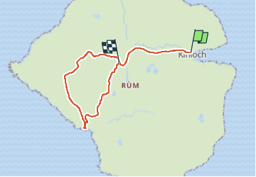
![](/images/other/stat-length.png)
![Trail On foot Unknown - Orval, return via Harris - Photo](https://media.geolcdn.com/t/1900/400/c468dca8-43f0-4964-9d3b-4bf912547b78.jpeg&format=pjpeg&maxdim=2)
Orval, return via Harris
SityTrail - itinéraires balisés pédestres
Tous les sentiers balisés d’Europe GUIDE+
![Length](/images/other/stat-length.png)
![Max alt](https://static1.geolcdn.com/siteimages/upload/files/1508320355ic_sort_altitude_max_24dp.png)
![Uphill gradient](https://static1.geolcdn.com/siteimages/upload/files/1508320355ic_sort_den_pos_24dp.png)
![Km-Effort](/images/other/stat-length.png)
![Min alt](https://static1.geolcdn.com/siteimages/upload/files/1508320355ic_sort_altitude_min_24dp.png)
![Downhill gradient](https://static1.geolcdn.com/siteimages/upload/files/1508320355ic_sort_den_neg_24dp.png)
![Boucle](https://static1.geolcdn.com/siteimages/upload/files/16400158638029165_repeat_loop_refresh_sync_direction_icon.png)
![On foot](https://static1.geolcdn.com/sitytour/trail-icons/100.png)
6h33
Difficulty : Medium
![Scan this QR Code to open this trail in the SityTrail application](https://capi.geolives.com/qq0zvz2zws4bq2lad0pu/sitytour/trails/4341815/qr.png?size=200)
FREE GPS app for hiking
About
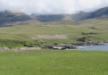
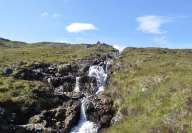
Trail On foot of 18.5 km to be discovered at Scotland, Highland. This trail is proposed by SityTrail - itinéraires balisés pédestres.
Description
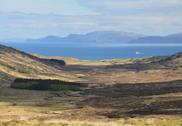
Orval is the highest of the hills in the northern half of Rum, a superb viewpoint for both the Rum and Skye Cuillin and surrounding islands, with a dramatic craggy escarpment of its own. The descent leads to Harris on Rum's western coastline, the site of the Bullough's mausoleum and a beautiful location in its own right, before a long return on tracks to Kinloch.
Website: https://www.walkhighlands.co.uk/islands/orval-harris.shtml
Positioning
Comments
Trails nearby
![Trail On foot - Rum Cuillin traverse - Photo](https://media.geolcdn.com/t/375/260/c468dca8-43f0-4964-9d3b-4bf912547b78.jpeg&format=jpg&maxdim=2)
![On foot On foot](https://static1.geolcdn.com/sitytour/trail-icons/100.png)
On foot
![](/images/other/stat-length.png)
![](https://static1.geolcdn.com/siteimages/upload/files/16400158638029165_repeat_loop_refresh_sync_direction_icon.png)
![Trail On foot - Out-and-back walk to Harris from Kinloch - Photo](https://media.geolcdn.com/t/375/260/99c331cb-7ed5-4e99-8161-e3a673d5f1a7.jpeg&format=jpg&maxdim=2)
![On foot On foot](https://static1.geolcdn.com/sitytour/trail-icons/100.png)
On foot
![](/images/other/stat-length.png)
![](https://static1.geolcdn.com/siteimages/upload/files/16400158638029165_repeat_loop_refresh_sync_direction_icon.png)
![Trail On foot - Hallival and Barkeval - Photo](https://media.geolcdn.com/t/375/260/8c8ca3df-2bdc-4b5d-87c8-2537fa733032.jpeg&format=jpg&maxdim=2)
![On foot On foot](https://static1.geolcdn.com/sitytour/trail-icons/100.png)
On foot
![](/images/other/stat-length.png)
![](https://static1.geolcdn.com/siteimages/upload/files/16400158638029165_repeat_loop_refresh_sync_direction_icon.png)
![Trail On foot - Kilmory Bay - Photo](https://media.geolcdn.com/t/375/260/281f2b0a-5c72-4e96-a97c-66de1616b5d2.jpeg&format=jpg&maxdim=2)
![On foot On foot](https://static1.geolcdn.com/sitytour/trail-icons/100.png)