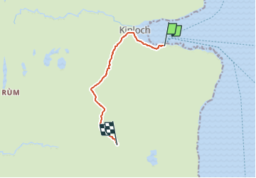
![](/images/other/stat-length.png)
![Trail On foot Unknown - Hallival and Barkeval - Photo](https://media.geolcdn.com/t/1900/400/8c8ca3df-2bdc-4b5d-87c8-2537fa733032.jpeg&format=pjpeg&maxdim=2)
Hallival and Barkeval
SityTrail - itinéraires balisés pédestres
Tous les sentiers balisés d’Europe GUIDE+
![Length](/images/other/stat-length.png)
![Max alt](https://static1.geolcdn.com/siteimages/upload/files/1508320355ic_sort_altitude_max_24dp.png)
![Uphill gradient](https://static1.geolcdn.com/siteimages/upload/files/1508320355ic_sort_den_pos_24dp.png)
![Km-Effort](/images/other/stat-length.png)
![Min alt](https://static1.geolcdn.com/siteimages/upload/files/1508320355ic_sort_altitude_min_24dp.png)
![Downhill gradient](https://static1.geolcdn.com/siteimages/upload/files/1508320355ic_sort_den_neg_24dp.png)
![Boucle](https://static1.geolcdn.com/siteimages/upload/files/16400158638029165_repeat_loop_refresh_sync_direction_icon.png)
![On foot](https://static1.geolcdn.com/sitytour/trail-icons/100.png)
2h50
Difficulty : Easy
![Scan this QR Code to open this trail in the SityTrail application](https://capi.geolives.com/qq0zvz2zws4bq2lad0pu/sitytour/trails/4341808/qr.png?size=200)
FREE GPS app for hiking
About
Trail On foot of 5.6 km to be discovered at Scotland, Highland. This trail is proposed by SityTrail - itinéraires balisés pédestres.
Description
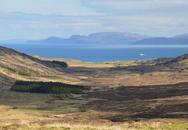
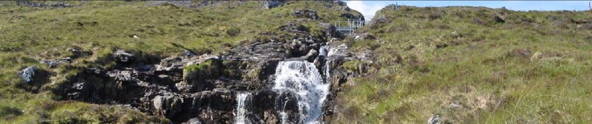
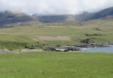
These two most northerly summits in the Rum Cuillin are the closest to Kinloch and give a magnificent hillwalk. The terrain is steep and rocky on Hallival especially, but these two hills still give much easier going than the main summits if the full round of the Rum Cuillin is too difficult. They give astonishing views of mountain and sea.
Website: https://www.walkhighlands.co.uk/islands/barkeval-hallival.shtml
Positioning
Comments
Trails nearby
![Trail On foot - Rum Cuillin traverse - Photo](https://media.geolcdn.com/t/375/260/c468dca8-43f0-4964-9d3b-4bf912547b78.jpeg&format=jpg&maxdim=2)
![On foot On foot](https://static1.geolcdn.com/sitytour/trail-icons/100.png)
On foot
![](/images/other/stat-length.png)
![](https://static1.geolcdn.com/siteimages/upload/files/16400158638029165_repeat_loop_refresh_sync_direction_icon.png)
![Trail On foot - Orval, return via Harris - Photo](https://media.geolcdn.com/t/375/260/c468dca8-43f0-4964-9d3b-4bf912547b78.jpeg&format=jpg&maxdim=2)
![On foot On foot](https://static1.geolcdn.com/sitytour/trail-icons/100.png)
On foot
![](/images/other/stat-length.png)
![](https://static1.geolcdn.com/siteimages/upload/files/16400158638029165_repeat_loop_refresh_sync_direction_icon.png)
![Trail On foot - Out-and-back walk to Harris from Kinloch - Photo](https://media.geolcdn.com/t/375/260/99c331cb-7ed5-4e99-8161-e3a673d5f1a7.jpeg&format=jpg&maxdim=2)
![On foot On foot](https://static1.geolcdn.com/sitytour/trail-icons/100.png)
On foot
![](/images/other/stat-length.png)
![](https://static1.geolcdn.com/siteimages/upload/files/16400158638029165_repeat_loop_refresh_sync_direction_icon.png)
![Trail On foot - Kilmory Bay - Photo](https://media.geolcdn.com/t/375/260/281f2b0a-5c72-4e96-a97c-66de1616b5d2.jpeg&format=jpg&maxdim=2)
![On foot On foot](https://static1.geolcdn.com/sitytour/trail-icons/100.png)