Trail On foot Unknown - Bath Skyline - Photo

Tous les sentiers balisés d’Europe GUIDE+

© OpenStreetMap contributors
Length
Length
9.3 km
Max alt
Max alt
191 m
Uphill gradient
Uphill gradient
202 m
Km-Effort
Km-Effort  
12 km
Min alt
Min alt
55 m
Downhill gradient
Downhill gradient
203 m
Boucle
Boucle
Yes
Signpost
Signpost
Creation date :
2025-02-05 11:01:03.676
Updated on :
2025-02-05 11:01:03.676

(0 Reviews)

On foot
On foot
2h43
Difficulty : Easy

Scan this QR Code to open this trail in the SityTrail application

FREE GPS app for hiking

Logo SityTrail SityTrail

IGN / Geographical institutes

Download SityTrail from the App Store Download SityTrail from Google Play

Logo SityTrail SityTrail World

The world is yours!

Download SityTrail from the App Store Download SityTrail from Google Play Download SityTrail on Huawei AppGallery

About

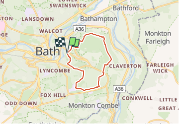
Trail On foot of 9.3 km to be discovered at England, Bath and North East Somerset. This trail is proposed by SityTrail - itinéraires balisés pédestres.

Description

Explore the fascinating area around Bath along the six miles of footpaths that make up the National Trust's Bath Skyline walk.

Website: https://www.nationaltrust.org.uk/bath-skyline/

Elevation profile

Photos

Positioning

Country:
United Kingdom
Region :
England
Department/Province :
Bath and North East Somerset
Municipality :
Unknown
Location:
Unknown
Start:(UTM)
545517 ; 5692343 (30U) N.

Trails nearby

Trail Walking  - j9 Bath  - Photo
Walking
himpececilia

Walking

Difficult
, England, Bath and North East Somerset, United Kingdom
12.5 km | 14.6 km-effort
3h 1min
No
Trail Walking  - j8 Bradford on avon - Photo
Walking
himpececilia

Walking

Medium
, England, Bath and North East Somerset, United Kingdom
9.9 km | 11.4 km-effort
2h 35min
No
Trail Walking  - j7 Bath Skyline, vergers, cimetière  - Photo
Walking
himpececilia

Walking

Difficult
, England, Bath and North East Somerset, United Kingdom
10.7 km | 14.1 km-effort
3h 11min
Yes


Close
My subscriptions