Trail On foot Blaby - Bridleway V29 - Photo

Tous les sentiers balisés d’Europe GUIDE+

© OpenStreetMap contributors
Length
Length
3.9 km
Max alt
Max alt
113 m
Uphill gradient
Uphill gradient
40 m
Km-Effort
Km-Effort  
4.4 km
Min alt
Min alt
87 m
Downhill gradient
Downhill gradient
16 m
Boucle
Boucle
No
Signpost
Signpost
Creation date :
2025-02-05 10:34:08.625
Updated on :
2025-02-05 10:34:08.625

(0 Reviews)

On foot
On foot
1h00
Difficulty : Easy

Scan this QR Code to open this trail in the SityTrail application

FREE GPS app for hiking

Logo SityTrail SityTrail

IGN / Geographical institutes

Download SityTrail from the App Store Download SityTrail from Google Play

Logo SityTrail SityTrail World

The world is yours!

Download SityTrail from the App Store Download SityTrail from Google Play Download SityTrail on Huawei AppGallery

About

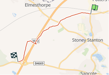
Trail On foot of 3.9 km to be discovered at England, Leicestershire, Blaby. This trail is proposed by SityTrail - itinéraires balisés pédestres.

Description

From Aston lane, Sharnford to the M69/A5070 junction, then north east across Hinckley Road on both sides of the motorway and to Huncote Road, Stoney Stanton

Elevation profile

Positioning

Country:
United Kingdom
Region :
England
Department/Province :
Leicestershire
Municipality :
Blaby
Location:
Unknown
Start:(UTM)
616672 ; 5824403 (30U) N.

Trails nearby

Trail On foot Blaby - Bridleway V44 - Photo
On foot
GUIDE+

On foot

Easy
Blaby, England, Leicestershire, United Kingdom
3.3 km | 3.5 km-effort
47min
No


Close
My subscriptions