![Trail On foot Unknown - Wigmore Loop - Photo](https://media.geolcdn.com/t/1900/400/c1d6306a-c225-462e-9bc9-accd48317850.jpeg&format=pjpeg&maxdim=2)
Wigmore Loop
SityTrail - itinéraires balisés pédestres
Tous les sentiers balisés d’Europe GUIDE+
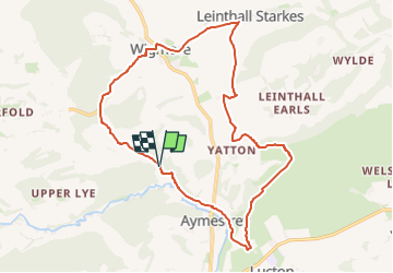
![Length](/images/other/stat-length.png)
Length
16.1 km
![Max alt](https://static1.geolcdn.com/siteimages/upload/files/1508320355ic_sort_altitude_max_24dp.png)
Max alt
282 m
![Uphill gradient](https://static1.geolcdn.com/siteimages/upload/files/1508320355ic_sort_den_pos_24dp.png)
Uphill gradient
345 m
![Km-Effort](/images/other/stat-length.png)
Km-Effort
21 km
![Min alt](https://static1.geolcdn.com/siteimages/upload/files/1508320355ic_sort_altitude_min_24dp.png)
Min alt
103 m
![Downhill gradient](https://static1.geolcdn.com/siteimages/upload/files/1508320355ic_sort_den_neg_24dp.png)
Downhill gradient
343 m
![Boucle](https://static1.geolcdn.com/siteimages/upload/files/16400158638029165_repeat_loop_refresh_sync_direction_icon.png)
Boucle
Yes
Signpost
Creation date :
2025-02-05 10:26:39.426
Updated on :
2025-02-05 10:26:39.426
![On foot](https://static1.geolcdn.com/sitytour/trail-icons/100.png)
4h42
Difficulty : Medium
![Scan this QR Code to open this trail in the SityTrail application](https://capi.geolives.com/qq0zvz2zws4bq2lad0pu/sitytour/trails/4341159/qr.png?size=200)
FREE GPS app for hiking
About
Trail On foot of 16.1 km to be discovered at England, Herefordshire. This trail is proposed by SityTrail - itinéraires balisés pédestres.
Positioning
Country:
United Kingdom
Region :
England
Department/Province :
Herefordshire
Municipality :
Unknown
Location:
Unknown
Start:(Dec)
Start:(UTM)
509547 ; 5793644 (30U) N.
Comments
Trails nearby