![](/images/other/stat-length.png)
![Trail Walking Valernes - ROCHERS DE HONGRIE ( Jabron 02 2025) - Photo](https://media.geolcdn.com/t/1900/400/8cced938-ad68-41b9-a956-29760787e4b5.jpg&format=pjpeg&maxdim=2)
ROCHERS DE HONGRIE ( Jabron 02 2025)
LEGUE
User
![Length](/images/other/stat-length.png)
Length
49 km
![Max alt](https://static1.geolcdn.com/siteimages/upload/files/1508320355ic_sort_altitude_max_24dp.png)
Max alt
1190 m
![Uphill gradient](https://static1.geolcdn.com/siteimages/upload/files/1508320355ic_sort_den_pos_24dp.png)
Uphill gradient
1155 m
![Km-Effort](/images/other/stat-length.png)
Km-Effort
63 km
![Min alt](https://static1.geolcdn.com/siteimages/upload/files/1508320355ic_sort_altitude_min_24dp.png)
Min alt
459 m
![Downhill gradient](https://static1.geolcdn.com/siteimages/upload/files/1508320355ic_sort_den_neg_24dp.png)
Downhill gradient
1004 m
![Boucle](https://static1.geolcdn.com/siteimages/upload/files/16400158638029165_repeat_loop_refresh_sync_direction_icon.png)
Boucle
No
Creation date :
2025-02-04 08:19:41.0
Updated on :
2025-02-04 16:15:30.361
![Walking](https://static1.geolcdn.com/sitytour/trail-icons/101.png)
2h00
Difficulty : Very easy
![Scan this QR Code to open this trail in the SityTrail application](https://capi.geolives.com/qq0zvz2zws4bq2lad0pu/sitytour/trails/4340441/qr.png?size=200)
FREE GPS app for hiking
About
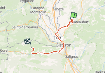
Trail Walking of 49 km to be discovered at Provence-Alpes-Côte d'Azur, Alpes-de-Haute-Provence, Valernes. This trail is proposed by LEGUE.
Description
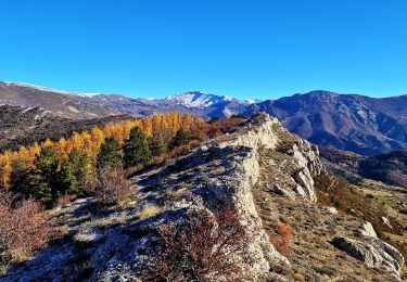
Petite randonnée sans beaucoup d’intérêt sur une piste forestière qui débouche sur un relais … pose et déjeuner sur le sommet …
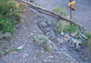
Positioning
Country:
France
Region :
Provence-Alpes-Côte d'Azur
Department/Province :
Alpes-de-Haute-Provence
Municipality :
Valernes
Location:
Unknown
Start:(Dec)
Start:(UTM)
737148 ; 4906683 (31T) N.
Comments
Trails nearby
![Trail Walking Saint-Geniez - Pierre écrite et montagne de Gache - Photo](https://media.geolcdn.com/t/375/260/7a1ca822-6c04-425e-94b9-5be1080d03a0.jpg&format=jpg&maxdim=2)
![Walking Walking](https://static1.geolcdn.com/sitytour/trail-icons/101.png)
Pierre écrite et montagne de Gache
Walking
Easy
Saint-Geniez,
Provence-Alpes-Côte d'Azur,
Alpes-de-Haute-Provence,
France
![](/images/other/stat-length.png)
7.4 km | 12.3 km-effort
2h 38min
![](https://static1.geolcdn.com/siteimages/upload/files/16400158638029165_repeat_loop_refresh_sync_direction_icon.png)
Yes
![Trail On foot Saint-Geniez - tour-de-la-montagne-de-gache_gpx - Photo](https://media.geolcdn.com/t/375/260/ext.jpg?maxdim=2&url=https%3A%2F%2Fstatic1.geolcdn.com%2Fsiteimages%2Fupload%2Ffiles%2F1545311037marcheuse_200dpi.jpg)
![On foot On foot](https://static1.geolcdn.com/sitytour/trail-icons/100.png)
tour-de-la-montagne-de-gache_gpx
On foot
Easy
(1)
Saint-Geniez,
Provence-Alpes-Côte d'Azur,
Alpes-de-Haute-Provence,
France
![](/images/other/stat-length.png)
12.2 km | 22 km-effort
Unknown
![](https://static1.geolcdn.com/siteimages/upload/files/16400158638029165_repeat_loop_refresh_sync_direction_icon.png)
Yes
![Trail Walking Saint-Geniez - 230629 Pierre écrite falaise de Gache - Photo](https://media.geolcdn.com/t/375/260/a735d81d-652a-4bd0-be42-a24d172d6998.jpg&format=jpg&maxdim=2)
![Walking Walking](https://static1.geolcdn.com/sitytour/trail-icons/101.png)
230629 Pierre écrite falaise de Gache
Walking
Difficult
Saint-Geniez,
Provence-Alpes-Côte d'Azur,
Alpes-de-Haute-Provence,
France
![](/images/other/stat-length.png)
8.4 km | 13.6 km-effort
3h 4min
![](https://static1.geolcdn.com/siteimages/upload/files/16400158638029165_repeat_loop_refresh_sync_direction_icon.png)
No
![Trail Walking Nibles - NIBLES . CANAL DU MOULIN . PASSAGE DE L HOMME MORT . S JACQUES O L - Photo](https://media.geolcdn.com/t/375/260/2fa73386-20dc-44c2-aea9-4ca90b12e862.jpg&format=jpg&maxdim=2)
![Walking Walking](https://static1.geolcdn.com/sitytour/trail-icons/101.png)
NIBLES . CANAL DU MOULIN . PASSAGE DE L HOMME MORT . S JACQUES O L
Walking
Medium
Nibles,
Provence-Alpes-Côte d'Azur,
Alpes-de-Haute-Provence,
France
![](/images/other/stat-length.png)
13.7 km | 20 km-effort
3h 20min
![](https://static1.geolcdn.com/siteimages/upload/files/16400158638029165_repeat_loop_refresh_sync_direction_icon.png)
Yes
![Trail Walking Saint-Geniez - Crête d’Aigues Champ Via Riou de Jabron - Photo](https://media.geolcdn.com/t/375/260/92e7654c-81cc-460b-8306-03a73a1ffc52.jpg&format=jpg&maxdim=2)
![Walking Walking](https://static1.geolcdn.com/sitytour/trail-icons/101.png)
Crête d’Aigues Champ Via Riou de Jabron
Walking
Very difficult
Saint-Geniez,
Provence-Alpes-Côte d'Azur,
Alpes-de-Haute-Provence,
France
![](/images/other/stat-length.png)
10.1 km | 16.8 km-effort
5h 44min
![](https://static1.geolcdn.com/siteimages/upload/files/16400158638029165_repeat_loop_refresh_sync_direction_icon.png)
Yes
![Trail Walking Thèze - Boucle Theze Sigoyer depart Theze - Photo](https://media.geolcdn.com/t/375/260/91670e8d-b25b-43eb-b3a3-a9631c3bd51e.jpg&format=jpg&maxdim=2)
![Walking Walking](https://static1.geolcdn.com/sitytour/trail-icons/101.png)
Boucle Theze Sigoyer depart Theze
Walking
Easy
Thèze,
Provence-Alpes-Côte d'Azur,
Alpes-de-Haute-Provence,
France
![](/images/other/stat-length.png)
11.4 km | 15.7 km-effort
3h 8min
![](https://static1.geolcdn.com/siteimages/upload/files/16400158638029165_repeat_loop_refresh_sync_direction_icon.png)
Yes
![Trail Walking Saint-Geniez - Pierre-Écrite - Photo](https://media.geolcdn.com/t/375/260/ext.jpg?maxdim=2&url=https%3A%2F%2Fservices.sitytrail.com%2FGeolivesWS%2FDownloadMedia.ashx%3FTrailID%3D167605%26Media%3D20121228155252.jpg)
![Walking Walking](https://static1.geolcdn.com/sitytour/trail-icons/101.png)
Pierre-Écrite
Walking
Very easy
Saint-Geniez,
Provence-Alpes-Côte d'Azur,
Alpes-de-Haute-Provence,
France
![](/images/other/stat-length.png)
3.4 km | 4.7 km-effort
1h 9min
![](https://static1.geolcdn.com/siteimages/upload/files/16400158638029165_repeat_loop_refresh_sync_direction_icon.png)
Yes
![Trail Walking Thèze - La tournée des chênes - Thèze - Photo](https://media.geolcdn.com/t/375/260/ext.jpg?maxdim=2&url=https%3A%2F%2Fservices.sitytrail.com%2FGeolivesWS%2FDownloadMedia.ashx%3FTrailID%3D112813%26Media%3D12505_5.jpg)
![Walking Walking](https://static1.geolcdn.com/sitytour/trail-icons/101.png)
La tournée des chênes - Thèze
Walking
Medium
(1)
Thèze,
Provence-Alpes-Côte d'Azur,
Alpes-de-Haute-Provence,
France
![](/images/other/stat-length.png)
8.9 km | 12.5 km-effort
2h 30min
![](https://static1.geolcdn.com/siteimages/upload/files/16400158638029165_repeat_loop_refresh_sync_direction_icon.png)
Yes
![Trail Walking Nibles - La boucle de Saint Jacques - Nibles - Photo](https://media.geolcdn.com/t/375/260/ext.jpg?maxdim=2&url=https%3A%2F%2Fservices.sitytrail.com%2FGeolivesWS%2FDownloadMedia.ashx%3FTrailID%3D112804%26Media%3D12464_5.jpg)
![Walking Walking](https://static1.geolcdn.com/sitytour/trail-icons/101.png)
La boucle de Saint Jacques - Nibles
Walking
Difficult
Nibles,
Provence-Alpes-Côte d'Azur,
Alpes-de-Haute-Provence,
France
![](/images/other/stat-length.png)
13.1 km | 18.9 km-effort
3h 30min
![](https://static1.geolcdn.com/siteimages/upload/files/16400158638029165_repeat_loop_refresh_sync_direction_icon.png)
Yes