Trail On foot Bolsover - Archaeological Way (old route) - Photo

Archaeological Way (old route)

Tous les sentiers balisés d’Europe GUIDE+

© OpenStreetMap contributors
Length
Length
23 km
Max alt
Max alt
175 m
Uphill gradient
Uphill gradient
229 m
Km-Effort
Km-Effort  
26 km
Min alt
Min alt
88 m
Downhill gradient
Downhill gradient
228 m
Boucle
Boucle
No
Signpost
Signpost
Creation date :
2025-02-04 10:55:16.542
Updated on :
2025-02-05 08:13:34.85

(0 Reviews)

On foot
On foot
5h55
Difficulty : Medium

Scan this QR Code to open this trail in the SityTrail application

FREE GPS app for hiking

Logo SityTrail SityTrail

IGN / Geographical institutes

Download SityTrail from the App Store Download SityTrail from Google Play

Logo SityTrail SityTrail World

The world is yours!

Download SityTrail from the App Store Download SityTrail from Google Play Download SityTrail on Huawei AppGallery

About

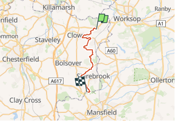
Trail On foot of 23 km to be discovered at England, Derbyshire, Bolsover. This trail is proposed by SityTrail - itinéraires balisés pédestres.

Description

This is the "original" Archaeological Way. See https://wiki.openstreetmap.org/wiki/Nottinghamshire#Long-distance_Paths .

Elevation profile

Photos

Positioning

Country:
United Kingdom
Region :
England
Department/Province :
Derbyshire
Municipality :
Bolsover
Location:
Unknown
Start:(UTM)
619215 ; 5905540 (30U) N.

Trails nearby

Trail On foot Rotherham - Rotherham Ring - Photo
On foot
GUIDE+

On foot

Easy
Rotherham, England, Unknown, United Kingdom
3.8 km | 4.2 km-effort
57min
No


Close
My subscriptions