![](/images/other/stat-length.png)
![Trail Walking Bunzac - La randonnée de puy cocu et la fosse de la femme morte - Photo](https://media.geolcdn.com/t/1900/400/ext.pjpeg?maxdim=2&url=https%3A%2F%2Fstatic1.geolcdn.com%2Fsiteimages%2Fupload%2Ffiles%2F1553511878bg_sport_marche.png)
La randonnée de puy cocu et la fosse de la femme morte
alainjoseph6
User
![Length](/images/other/stat-length.png)
Length
9.3 km
![Max alt](https://static1.geolcdn.com/siteimages/upload/files/1508320355ic_sort_altitude_max_24dp.png)
Max alt
123 m
![Uphill gradient](https://static1.geolcdn.com/siteimages/upload/files/1508320355ic_sort_den_pos_24dp.png)
Uphill gradient
121 m
![Km-Effort](/images/other/stat-length.png)
Km-Effort
10.9 km
![Min alt](https://static1.geolcdn.com/siteimages/upload/files/1508320355ic_sort_altitude_min_24dp.png)
Min alt
79 m
![Downhill gradient](https://static1.geolcdn.com/siteimages/upload/files/1508320355ic_sort_den_neg_24dp.png)
Downhill gradient
120 m
![Boucle](https://static1.geolcdn.com/siteimages/upload/files/16400158638029165_repeat_loop_refresh_sync_direction_icon.png)
Boucle
Yes
Creation date :
2025-02-02 09:20:07.844
Updated on :
2025-02-10 09:31:18.637
![Walking](https://static1.geolcdn.com/sitytour/trail-icons/101.png)
2h28
Difficulty : Medium
![Scan this QR Code to open this trail in the SityTrail application](https://capi.geolives.com/qq0zvz2zws4bq2lad0pu/sitytour/trails/4337267/qr.png?size=200)
FREE GPS app for hiking
About
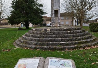
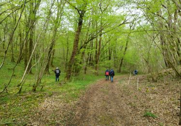
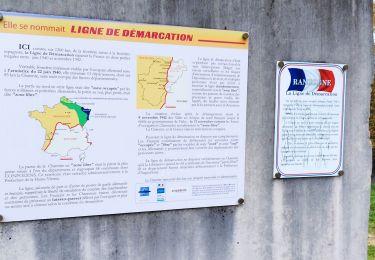
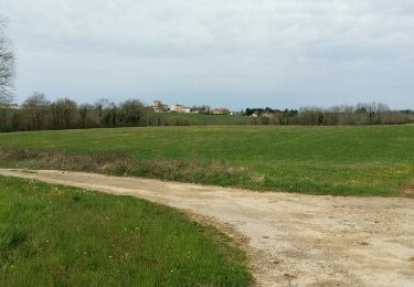
Trail Walking of 9.3 km to be discovered at New Aquitaine, Charente, Bunzac. This trail is proposed by alainjoseph6.
Description
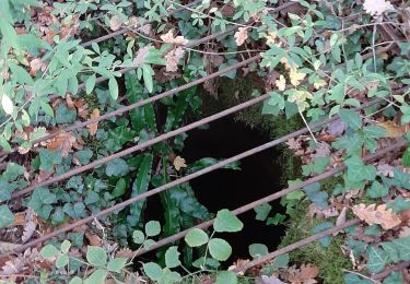
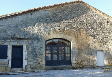
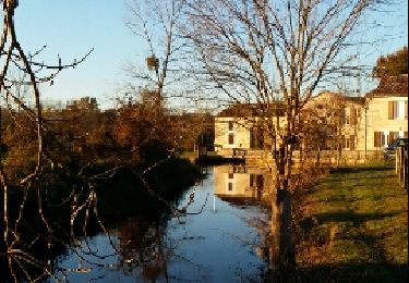
Au départ de la place de puy cocu en découvrant sa fosse ovoîde ,puis le moulin de trotte renard ,en passant par la fosse de la femme morte , le village de chez Monot ,celui de Marsac et retour à puy cocu
Positioning
Country:
France
Region :
New Aquitaine
Department/Province :
Charente
Municipality :
Bunzac
Location:
Unknown
Start:(Dec)
Start:(UTM)
293685 ; 5062629 (31T) N.
Comments
Trails nearby
![Trail Walking Pranzac - Pranzac et ses petits villages. - Photo](https://media.geolcdn.com/t/375/260/3a77c9e3-0523-4318-8510-a2c1a4b859f3.jpg&format=jpg&maxdim=2)
![Walking Walking](https://static1.geolcdn.com/sitytour/trail-icons/101.png)
Pranzac et ses petits villages.
Walking
Medium
Pranzac,
New Aquitaine,
Charente,
France
![](/images/other/stat-length.png)
7.8 km | 9 km-effort
2h 26min
![](https://static1.geolcdn.com/siteimages/upload/files/16400158638029165_repeat_loop_refresh_sync_direction_icon.png)
Yes
![Trail Walking Bunzac - La randonnée de l'ail des ours de Bunzac. - Photo](https://media.geolcdn.com/t/375/260/3caec311-6335-451e-8b98-07699b2429c2.jpg&format=jpg&maxdim=2)
![Walking Walking](https://static1.geolcdn.com/sitytour/trail-icons/101.png)
La randonnée de l'ail des ours de Bunzac.
Walking
Medium
Bunzac,
New Aquitaine,
Charente,
France
![](/images/other/stat-length.png)
9.3 km | 10.9 km-effort
2h 28min
![](https://static1.geolcdn.com/siteimages/upload/files/16400158638029165_repeat_loop_refresh_sync_direction_icon.png)
Yes
![Trail Walking Moulins-sur-Tardoire - Rancogne ...le moulin de la pierre .. le moulin de la Forge - Photo](https://media.geolcdn.com/t/375/260/7d73b553-8243-4d54-9954-814f9d3846b0.jpg&format=jpg&maxdim=2)
![Walking Walking](https://static1.geolcdn.com/sitytour/trail-icons/101.png)
Rancogne ...le moulin de la pierre .. le moulin de la Forge
Walking
Medium
Moulins-sur-Tardoire,
New Aquitaine,
Charente,
France
![](/images/other/stat-length.png)
7.5 km | 8.6 km-effort
2h 26min
![](https://static1.geolcdn.com/siteimages/upload/files/16400158638029165_repeat_loop_refresh_sync_direction_icon.png)
Yes
![Trail Walking Chazelles - Les Grottes du Quéroy -gros terme et Combe - Photo](https://media.geolcdn.com/t/375/260/a902d7b3-47f7-4cd6-b06e-56e13f719b7b.jpg&format=jpg&maxdim=2)
![Walking Walking](https://static1.geolcdn.com/sitytour/trail-icons/101.png)
Les Grottes du Quéroy -gros terme et Combe
Walking
Medium
(1)
Chazelles,
New Aquitaine,
Charente,
France
![](/images/other/stat-length.png)
8.2 km | 9.6 km-effort
2h 24min
![](https://static1.geolcdn.com/siteimages/upload/files/16400158638029165_repeat_loop_refresh_sync_direction_icon.png)
Yes
![Trail Walking Bunzac - BUNZAC 16110 ..départ de Puy cocu > combebrune > les Denis > le château des deffends - Photo](https://media.geolcdn.com/t/375/260/7d0ff8b1-963c-44bc-be90-151320ae11e3.jpg&format=jpg&maxdim=2)
![Walking Walking](https://static1.geolcdn.com/sitytour/trail-icons/101.png)
BUNZAC 16110 ..départ de Puy cocu > combebrune > les Denis > le château des d...
Walking
Easy
Bunzac,
New Aquitaine,
Charente,
France
![](/images/other/stat-length.png)
9.3 km | 10.8 km-effort
3h 9min
![](https://static1.geolcdn.com/siteimages/upload/files/16400158638029165_repeat_loop_refresh_sync_direction_icon.png)
Yes
![Trail Walking Chazelles - La randonnée autour de Chazelles - Photo](https://media.geolcdn.com/t/375/260/6a56e3fd-00be-447e-b74c-a7c93873ee51.jpg&format=jpg&maxdim=2)
![Walking Walking](https://static1.geolcdn.com/sitytour/trail-icons/101.png)
La randonnée autour de Chazelles
Walking
Easy
Chazelles,
New Aquitaine,
Charente,
France
![](/images/other/stat-length.png)
9.6 km | 11.1 km-effort
2h 32min
![](https://static1.geolcdn.com/siteimages/upload/files/16400158638029165_repeat_loop_refresh_sync_direction_icon.png)
Yes
![Trail Walking Bunzac - Entre BUNZAC et Landaudrie - Photo](https://media.geolcdn.com/t/375/260/ext.jpg?maxdim=2&url=https%3A%2F%2Fservices.sitytrail.com%2FGeolivesWS%2FDownloadMedia.ashx%3FTrailID%3D938198%26Media%3Dfix__20180407113315.jpg)
![Walking Walking](https://static1.geolcdn.com/sitytour/trail-icons/101.png)
Entre BUNZAC et Landaudrie
Walking
Easy
Bunzac,
New Aquitaine,
Charente,
France
![](/images/other/stat-length.png)
12.6 km | 14.7 km-effort
3h 7min
![](https://static1.geolcdn.com/siteimages/upload/files/16400158638029165_repeat_loop_refresh_sync_direction_icon.png)
Yes
![Trail Walking Bunzac - De Bunzac en passant par le chemin de la demoiselle. - Photo](https://media.geolcdn.com/t/375/260/ext.jpg?maxdim=2&url=https%3A%2F%2Fservices.sitytrail.com%2FGeolivesWS%2FDownloadMedia.ashx%3FTrailID%3D236221%26Media%3Dfix__20131207162753.jpg)
![Walking Walking](https://static1.geolcdn.com/sitytour/trail-icons/101.png)
De Bunzac en passant par le chemin de la demoiselle.
Walking
Very easy
Bunzac,
New Aquitaine,
Charente,
France
![](/images/other/stat-length.png)
10.4 km | 12.3 km-effort
2h 27min
![](https://static1.geolcdn.com/siteimages/upload/files/16400158638029165_repeat_loop_refresh_sync_direction_icon.png)
Yes
![Trail Mountain bike Chazelles - Chazelles - Brégout - Photo](https://media.geolcdn.com/t/375/260/ext.jpg?maxdim=2&url=https%3A%2F%2Fstatic1.geolcdn.com%2Fsiteimages%2Fupload%2Ffiles%2F1524743154velo.jpg)
![Mountain bike Mountain bike](https://static1.geolcdn.com/sitytour/trail-icons/202.png)
Chazelles - Brégout
Mountain bike
Difficult
(1)
Chazelles,
New Aquitaine,
Charente,
France
![](/images/other/stat-length.png)
46 km | 57 km-effort
4h 0min
![](https://static1.geolcdn.com/siteimages/upload/files/16400158638029165_repeat_loop_refresh_sync_direction_icon.png)
No