![](/images/other/stat-length.png)
![Trail Die - 2025-01-30_13h31m00_SityTrail - 4329096 - le-long-de-la-meyrosse- - Photo](https://media.geolcdn.com/t/1900/400/ext.pjpeg?maxdim=2&url=https%3A%2F%2Fsecurestorage.geolives.com%2Fsitytour%2Ftrail-bg%2Fdefault.jpg)
2025-01-30_13h31m00_SityTrail - 4329096 - le-long-de-la-meyrosse-
marobo
User
![Length](/images/other/stat-length.png)
![Max alt](https://static1.geolcdn.com/siteimages/upload/files/1508320355ic_sort_altitude_max_24dp.png)
![Uphill gradient](https://static1.geolcdn.com/siteimages/upload/files/1508320355ic_sort_den_pos_24dp.png)
![Km-Effort](/images/other/stat-length.png)
![Min alt](https://static1.geolcdn.com/siteimages/upload/files/1508320355ic_sort_altitude_min_24dp.png)
![Downhill gradient](https://static1.geolcdn.com/siteimages/upload/files/1508320355ic_sort_den_neg_24dp.png)
![Boucle](https://static1.geolcdn.com/siteimages/upload/files/16400158638029165_repeat_loop_refresh_sync_direction_icon.png)
![Scan this QR Code to open this trail in the SityTrail application](https://capi.geolives.com/qq0zvz2zws4bq2lad0pu/sitytour/trails/4334502/qr.png?size=200)
FREE GPS app for hiking
About
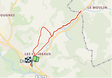
Trail of 8.4 km to be discovered at Auvergne-Rhône-Alpes, Drôme, Die. This trail is proposed by marobo.
Description
Die OT. Monter direction des Remparts. A la balise mi pente continuer tout droit jusqu'au plateau. Suivre le chemin. Au point 489 descendre la route pentue à droite qui nous ramène sur chemin des Fondeaux. Suivre à gauche la Meyrosse jusqu'au Pas de la Roche.
Attention petit passage rocailleux en arrivant à la passerelle. Retour par le chemin des Fondeaux jusqu'aux remparts et descente au parking. Pas de problème mais prudence en arrivant au Pas de la Roche. A faire au printemps bcp de fleurs....
Positioning
Comments
Trails nearby
![Trail Nordic walking Ponet-et-Saint-Auban - 20/12/2015 Pierre plats - Photo](https://media.geolcdn.com/t/375/260/ext.jpg?maxdim=2&url=https%3A%2F%2Fservices.sitytrail.com%2FGeolivesWS%2FDownloadMedia.ashx%3FTrailID%3D504514%26Media%3Dfix__20151220113452.jpg)
![Nordic walking Nordic walking](https://static1.geolcdn.com/sitytour/trail-icons/102.png)
Nordic walking
![](/images/other/stat-length.png)
![](https://static1.geolcdn.com/siteimages/upload/files/16400158638029165_repeat_loop_refresh_sync_direction_icon.png)
![Trail Mountain bike Chamaloc - Chamaloc - Hauteurs de Die - Photo](https://media.geolcdn.com/t/375/260/ext.jpg?maxdim=2&url=https%3A%2F%2Fservices.sitytrail.com%2FGeolivesWS%2FDownloadMedia.ashx%3FTrailID%3D106987%26Media%3D11765_1.jpg)
![Mountain bike Mountain bike](https://static1.geolcdn.com/sitytour/trail-icons/202.png)
Mountain bike
![](/images/other/stat-length.png)
![](https://static1.geolcdn.com/siteimages/upload/files/16400158638029165_repeat_loop_refresh_sync_direction_icon.png)
![Trail Walking Die - 26 belle justine - Photo](https://media.geolcdn.com/t/375/260/5057e97e-3818-4f77-b8e2-efbcea6a0e32.jpg&format=jpg&maxdim=2)
![Walking Walking](https://static1.geolcdn.com/sitytour/trail-icons/101.png)
Walking
![](/images/other/stat-length.png)
![](https://static1.geolcdn.com/siteimages/upload/files/16400158638029165_repeat_loop_refresh_sync_direction_icon.png)
![Trail Walking Die - Chapia Belle Justine - Photo](https://media.geolcdn.com/t/375/260/ext.jpg?maxdim=2&url=https%3A%2F%2Fstatic1.geolcdn.com%2Fsiteimages%2Fupload%2Ffiles%2F1553511878bg_sport_marche.png)
![Walking Walking](https://static1.geolcdn.com/sitytour/trail-icons/101.png)
Walking
![](/images/other/stat-length.png)
![](https://static1.geolcdn.com/siteimages/upload/files/16400158638029165_repeat_loop_refresh_sync_direction_icon.png)
![Trail sport Die - Val croissant comptoir des moutons - Photo](https://media.geolcdn.com/t/375/260/3b919326-2e50-400f-bc15-c6be506dcde0.jpg&format=jpg&maxdim=2)
sport
![](/images/other/stat-length.png)
![](https://static1.geolcdn.com/siteimages/upload/files/16400158638029165_repeat_loop_refresh_sync_direction_icon.png)
![Trail Walking Marignac-en-Diois - Marignac - But de l'Aiglette - Col de Vassieux - Photo](https://media.geolcdn.com/t/375/260/bb473351-63e3-46f2-ae98-67f0e2c869f6.jpg&format=jpg&maxdim=2)
![Walking Walking](https://static1.geolcdn.com/sitytour/trail-icons/101.png)
Walking
![](/images/other/stat-length.png)
![](https://static1.geolcdn.com/siteimages/upload/files/16400158638029165_repeat_loop_refresh_sync_direction_icon.png)
![Trail Walking Die - Col de Bergu - Photo](https://media.geolcdn.com/t/375/260/cd646939-5ef5-44d1-b09a-be899a9a43a7.jpg&format=jpg&maxdim=2)
![Walking Walking](https://static1.geolcdn.com/sitytour/trail-icons/101.png)
Walking
![](/images/other/stat-length.png)
![](https://static1.geolcdn.com/siteimages/upload/files/16400158638029165_repeat_loop_refresh_sync_direction_icon.png)
![Trail Walking Die - Abbaye de Valcroissant - Photo](https://media.geolcdn.com/t/375/260/a9356d67-59c3-4251-97a5-c480f0ff70f4.jpg&format=jpg&maxdim=2)
![Walking Walking](https://static1.geolcdn.com/sitytour/trail-icons/101.png)
Walking
![](/images/other/stat-length.png)
![](https://static1.geolcdn.com/siteimages/upload/files/16400158638029165_repeat_loop_refresh_sync_direction_icon.png)
![Trail sport Die - Croix de Justin , Ausson - Photo](https://media.geolcdn.com/t/375/260/c8090ee5-5a94-4ee1-b2d3-2c37d8bd6d5e.jpg&format=jpg&maxdim=2)
sport
![](/images/other/stat-length.png)
![](https://static1.geolcdn.com/siteimages/upload/files/16400158638029165_repeat_loop_refresh_sync_direction_icon.png)