![](/images/other/stat-length.png)
![Trail Walking Digne-les-Bains - De-digne-au-sommet-de-martignon-et-retour-par-courbons - Photo](https://media.geolcdn.com/t/1900/400/530c10a1-a2cf-4f9e-b8a2-a7590d62cd26.jpg&format=pjpeg&maxdim=2)
De-digne-au-sommet-de-martignon-et-retour-par-courbons
PapouBertrand
User
![Length](/images/other/stat-length.png)
![Max alt](https://static1.geolcdn.com/siteimages/upload/files/1508320355ic_sort_altitude_max_24dp.png)
![Uphill gradient](https://static1.geolcdn.com/siteimages/upload/files/1508320355ic_sort_den_pos_24dp.png)
![Km-Effort](/images/other/stat-length.png)
![Min alt](https://static1.geolcdn.com/siteimages/upload/files/1508320355ic_sort_altitude_min_24dp.png)
![Downhill gradient](https://static1.geolcdn.com/siteimages/upload/files/1508320355ic_sort_den_neg_24dp.png)
![Boucle](https://static1.geolcdn.com/siteimages/upload/files/16400158638029165_repeat_loop_refresh_sync_direction_icon.png)
![Walking](https://static1.geolcdn.com/sitytour/trail-icons/101.png)
5h48
Difficulty : Very difficult
![Scan this QR Code to open this trail in the SityTrail application](https://capi.geolives.com/qq0zvz2zws4bq2lad0pu/sitytour/trails/4334086/qr.png?size=200)
FREE GPS app for hiking
About
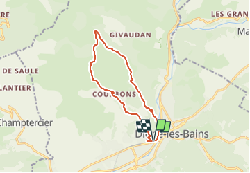
Trail Walking of 13 km to be discovered at Provence-Alpes-Côte d'Azur, Alpes-de-Haute-Provence, Digne-les-Bains. This trail is proposed by PapouBertrand.
Description
Très jolie randonnée réalisée par une journée d'hiver mêlant soleil, nuages et quelques rafales de vent. Le parcours débute en pleine ville, mais le sentier s'élève rapidement pour nous plonger dans la belle forêt du Bès.
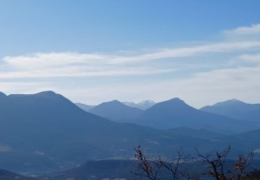
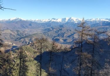
Le belvédère de Caguerenard offre une vue imprenable sur l'antique cité romaine de Dinia (Digne les Bains), tandis qu'au sommet de Martignon, une vue panoramique à 360° s'étend sur les massifs environnants, un véritable spectacle naturel. Pour conclure cette belle aventure, le retour traverse le charmant village de Courbons, ajoutant une touche pittoresque et authentique à cette journée inoubliable.
Points of interest
Positioning
Comments
Trails nearby
![Trail Walking Digne-les-Bains - Le Cousson - Photo](https://media.geolcdn.com/t/375/260/5cf44ebe-1058-41b6-9fbf-2454217c16da.jpg&format=jpg&maxdim=2)
![Walking Walking](https://static1.geolcdn.com/sitytour/trail-icons/101.png)
Walking
![](/images/other/stat-length.png)
![](https://static1.geolcdn.com/siteimages/upload/files/16400158638029165_repeat_loop_refresh_sync_direction_icon.png)
![Trail Walking Digne-les-Bains - Autour de Courbons - Digne les Bains - Photo](https://media.geolcdn.com/t/375/260/ext.jpg?maxdim=2&url=https%3A%2F%2Fservices.sitytrail.com%2FGeolivesWS%2FDownloadMedia.ashx%3FTrailID%3D173256%26Media%3D14871_6.jpg)
![Walking Walking](https://static1.geolcdn.com/sitytour/trail-icons/101.png)
Walking
![](/images/other/stat-length.png)
![](https://static1.geolcdn.com/siteimages/upload/files/16400158638029165_repeat_loop_refresh_sync_direction_icon.png)
![Trail Walking Digne-les-Bains - courbon la bigue 15kms 900m - Photo](https://media.geolcdn.com/t/375/260/eeca4995-0c3e-4d59-97a2-ea69c1d4e6a1.jpg&format=jpg&maxdim=2)
![Walking Walking](https://static1.geolcdn.com/sitytour/trail-icons/101.png)
Walking
![](/images/other/stat-length.png)
![](https://static1.geolcdn.com/siteimages/upload/files/16400158638029165_repeat_loop_refresh_sync_direction_icon.png)
![Trail Walking Digne-les-Bains - DIGNE. LA PLATRIERE. RUINES DE GIVAUDAN. CHAPELLE MADELEINE. O L S - Photo](https://media.geolcdn.com/t/375/260/80b6f901-b276-4568-b80a-9babbef2a5d9.jpg&format=jpg&maxdim=2)
![Walking Walking](https://static1.geolcdn.com/sitytour/trail-icons/101.png)
Walking
![](/images/other/stat-length.png)
![](https://static1.geolcdn.com/siteimages/upload/files/16400158638029165_repeat_loop_refresh_sync_direction_icon.png)
![Trail Walking Digne-les-Bains - Chapelle St Pancrace 18.11.23 - Photo](https://media.geolcdn.com/t/375/260/583976d8-25d3-4c43-8a1a-417f5de6b4ec.jpg&format=jpg&maxdim=2)
![Walking Walking](https://static1.geolcdn.com/sitytour/trail-icons/101.png)
Walking
![](/images/other/stat-length.png)
![](https://static1.geolcdn.com/siteimages/upload/files/16400158638029165_repeat_loop_refresh_sync_direction_icon.png)
![Trail Walking Digne-les-Bains - COURBONS , Le tour du Rouveyret o - Photo](https://media.geolcdn.com/t/375/260/70308cb0-d54c-40f6-bf71-d74c04a151e9.jpg&format=jpg&maxdim=2)
![Walking Walking](https://static1.geolcdn.com/sitytour/trail-icons/101.png)
Walking
![](/images/other/stat-length.png)
![](https://static1.geolcdn.com/siteimages/upload/files/16400158638029165_repeat_loop_refresh_sync_direction_icon.png)
![Trail Walking Digne-les-Bains - 65bis-Digne- Cousson N et S- Caramantran- Digne - Photo](https://media.geolcdn.com/t/375/260/ext.jpg?maxdim=2&url=https%3A%2F%2Fstatic1.geolcdn.com%2Fsiteimages%2Fupload%2Ffiles%2F1553511878bg_sport_marche.png)
![Walking Walking](https://static1.geolcdn.com/sitytour/trail-icons/101.png)
Walking
![](/images/other/stat-length.png)
![](https://static1.geolcdn.com/siteimages/upload/files/16400158638029165_repeat_loop_refresh_sync_direction_icon.png)
![Trail Mountain bike Digne-les-Bains - Terres Noires 2011 (50km) - Photo](https://media.geolcdn.com/t/375/260/ext.jpg?maxdim=2&url=https%3A%2F%2Fstatic1.geolcdn.com%2Fsiteimages%2Fupload%2Ffiles%2F1524743154velo.jpg)
![Mountain bike Mountain bike](https://static1.geolcdn.com/sitytour/trail-icons/202.png)
Mountain bike
![](/images/other/stat-length.png)
![](https://static1.geolcdn.com/siteimages/upload/files/16400158638029165_repeat_loop_refresh_sync_direction_icon.png)
![Trail Walking Digne-les-Bains - Digne-les-Bains cousson jean Roland 1161m 19.280kms - Photo](https://media.geolcdn.com/t/375/260/1697b584-afe7-4df9-868a-fe8a251bd8ac.jpg&format=jpg&maxdim=2)
![Walking Walking](https://static1.geolcdn.com/sitytour/trail-icons/101.png)
Walking
![](/images/other/stat-length.png)
![](https://static1.geolcdn.com/siteimages/upload/files/16400158638029165_repeat_loop_refresh_sync_direction_icon.png)