13.3 km | 19.3 km-effort
Font Romeu - Pic de Moros
lolyhalle
User
Length
16.8 km
Max alt
2131 m
Uphill gradient
525 m
Km-Effort
24 km
Min alt
1725 m
Downhill gradient
524 m
Boucle
Yes
Creation date :
2025-01-25 08:59:55.283
Updated on :
2025-01-25 08:59:56.96
5h24
Difficulty : Very difficult
FREE GPS app for hiking
About
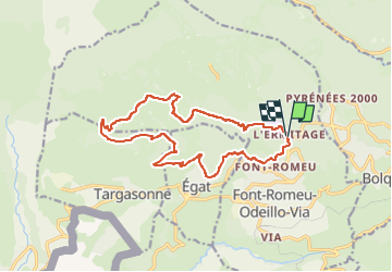
Trail Walking of 16.8 km to be discovered at Occitania, Pyrénées-Orientales, Font-Romeu-Odeillo-Via. This trail is proposed by lolyhalle.
Description
5h environ. Pic de Moros, Croix d'Egat.
Positioning
Country:
France
Region :
Occitania
Department/Province :
Pyrénées-Orientales
Municipality :
Font-Romeu-Odeillo-Via
Location:
Unknown
Start:(Dec)
Start:(UTM)
421620 ; 4707072 (31T) N.
Comments
Trails nearby
Coll del Pam lac des Bouillouses
Walking
Medium
(2)
Font-Romeu-Odeillo-Via,
Occitania,
Pyrénées-Orientales,
France
4h 10min
Yes
Eyne,col de Nuria,pic d'Eyne,Torre d'Eyne,Eyne.
Walking
Very difficult
(1)
Eyne,
Occitania,
Pyrénées-Orientales,
France
24 km | 43 km-effort
8h 44min
Yes
pic dels moros
Snowshoes
Medium
(1)
Font-Romeu-Odeillo-Via,
Occitania,
Pyrénées-Orientales,
France
12.6 km | 19.4 km-effort
4h 46min
Yes
Font Romeu Egat
Walking
Medium
(2)
Font-Romeu-Odeillo-Via,
Occitania,
Pyrénées-Orientales,
France
2.5 km | 3.4 km-effort
44min
Yes
Pic dels Moros avec Pierre
Snowshoes
Medium
(1)
Font-Romeu-Odeillo-Via,
Occitania,
Pyrénées-Orientales,
France
10.5 km | 15.9 km-effort
4h 4min
Yes
Egat Puig Moro
Walking
Medium
(1)
Égat,
Occitania,
Pyrénées-Orientales,
France
13.4 km | 19.3 km-effort
4h 51min
Yes
La croix d'Egat
Walking
Easy
(1)
Égat,
Occitania,
Pyrénées-Orientales,
France
7.1 km | 10.4 km-effort
2h 2min
Yes
Le Pic dels Moros
Walking
Difficult
(2)
Égat,
Occitania,
Pyrénées-Orientales,
France
12.1 km | 18.8 km-effort
5h 30min
Yes
Le Cambre d'Ase
Walking
Difficult
(1)
Eyne,
Occitania,
Pyrénées-Orientales,
France
8.9 km | 22 km-effort
4h 0min
Yes