GreenberryTree 250115 SityTrail > Trails > Outdoor > New Zealand > Canterbury > Christchurch City > Banks Peninsula Community SityTrail > Trails > Outdoor > New Zealand > Canterbury > Christchurch City > Banks Peninsula Community GreenberryTree 250115 JohnTompa User 3D © OpenStreetMap contributors Length 337 m Max alt 74 m Uphill gradient 11 m Km-Effort 457 m Min alt 58 m Downhill gradient 3 m Boucle Yes Creation date : 2025-01-14 23:20:13.586 Updated on : 2025-01-23 22:38:00.244 (0 Reviews) Walking 6m Difficulty : Easy FREE GPS app for hiking SityTrail IGN / Geographical institutes SityTrail World The world is yours! About Trail Walking of 337 m to be discovered at Canterbury, Christchurch City, Banks Peninsula Community. This trail is proposed by JohnTompa. Legends | More details (PDF) Elevation profile Legends > 15% 15% - 10% 10% - 5% flat 5% - 10% 10% - 15% 15% - 30% > 30% Positioning Country: New Zealand Region : Canterbury Department/Province : Christchurch City Municipality : Banks Peninsula Community Location: Unknown Start:(Dec) -43.60116196887957 / 172.68932926661367 Start:(UTM) 636345 ; 5171037 (59G) S. Comments Please log in to post a review or rate the element Trails nearby GUIDE+ Hiking trail On foot Easy Spreydon-Cashmere Community, Canterbury, Christchurch City, New Zealand 
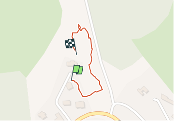
4.4 km | 8.3 km-effort 1h 53min No GUIDE+ Mount Herbert Walkway On foot Medium Banks Peninsula Community, Canterbury, Christchurch City, New Zealand 15.9 km | 28 km-effort 6h 23min No JohnTompa CassBay CraterRim BridalPath Lyttelton 250114 Walking Difficult Banks Peninsula Community, Canterbury, Christchurch City, New Zealand 5.5 km | 10.6 km-effort 4h 45min No JohnTompa Governors Bay Jetty 241228 Walking Easy Banks Peninsula Community, Canterbury, Christchurch City, New Zealand 2.2 km | 2.9 km-effort 53min Yes