![](/images/other/stat-length.png)
![Trail Walking Plancher-les-Mines - la planche des belles filles - Photo](https://media.geolcdn.com/t/1900/400/ext.pjpeg?maxdim=2&url=https%3A%2F%2Fstatic1.geolcdn.com%2Fsiteimages%2Fupload%2Ffiles%2F1553511878bg_sport_marche.png)
la planche des belles filles
grattounette
User
![Length](/images/other/stat-length.png)
Length
24 km
![Max alt](https://static1.geolcdn.com/siteimages/upload/files/1508320355ic_sort_altitude_max_24dp.png)
Max alt
1144 m
![Uphill gradient](https://static1.geolcdn.com/siteimages/upload/files/1508320355ic_sort_den_pos_24dp.png)
Uphill gradient
1403 m
![Km-Effort](/images/other/stat-length.png)
Km-Effort
43 km
![Min alt](https://static1.geolcdn.com/siteimages/upload/files/1508320355ic_sort_altitude_min_24dp.png)
Min alt
491 m
![Downhill gradient](https://static1.geolcdn.com/siteimages/upload/files/1508320355ic_sort_den_neg_24dp.png)
Downhill gradient
1404 m
![Boucle](https://static1.geolcdn.com/siteimages/upload/files/16400158638029165_repeat_loop_refresh_sync_direction_icon.png)
Boucle
Yes
Creation date :
2015-06-09 00:00:00.0
Updated on :
2015-06-09 00:00:00.0
![Walking](https://static1.geolcdn.com/sitytour/trail-icons/101.png)
8h41
Difficulty : Difficult
![Scan this QR Code to open this trail in the SityTrail application](https://capi.geolives.com/qq0zvz2zws4bq2lad0pu/sitytour/trails/431913/qr.png?size=200)
FREE GPS app for hiking
About
Trail Walking of 24 km to be discovered at Bourgogne-Franche-Comté, Haute-Saône, Plancher-les-Mines. This trail is proposed by grattounette.
Description
plancher les mines, col d'auxelles, auxelles haut, col du querty, chauveroche, étang des belles filles, tête carré, GR533, planche des belles filles
Positioning
Country:
France
Region :
Bourgogne-Franche-Comté
Department/Province :
Haute-Saône
Municipality :
Plancher-les-Mines
Location:
Unknown
Start:(Dec)
Start:(UTM)
330775 ; 5292222 (32T) N.
Comments
Trails nearby
![Trail Walking Auxelles-Haut - planche belles filles par auxelle haut - Photo](https://media.geolcdn.com/t/375/260/ext.jpg?maxdim=2&url=https%3A%2F%2Fservices.sitytrail.com%2FGeolivesWS%2FDownloadMedia.ashx%3FTrailID%3D305224%26Media%3D10d34718-818e-4b54-8a0e-bb1d508617db.JPG)
![Walking Walking](https://static1.geolcdn.com/sitytour/trail-icons/101.png)
planche belles filles par auxelle haut
Walking
Medium
(3)
Auxelles-Haut,
Bourgogne-Franche-Comté,
Territoire-de-Belfort,
France
![](/images/other/stat-length.png)
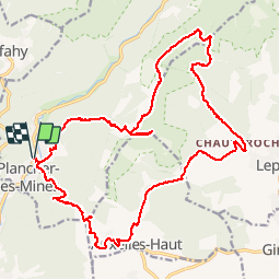
14.6 km | 23 km-effort
4h 55min
![](https://static1.geolcdn.com/siteimages/upload/files/16400158638029165_repeat_loop_refresh_sync_direction_icon.png)
Yes
![Trail Walking Plancher-les-Mines - Le Ballon de Servance - Photo](https://media.geolcdn.com/t/375/260/ext.jpg?maxdim=2&url=https%3A%2F%2Fservices.sitytrail.com%2FGeolivesWS%2FDownloadMedia.ashx%3FTrailID%3D109643%26Media%3D4284_1.jpg)
![Walking Walking](https://static1.geolcdn.com/sitytour/trail-icons/101.png)
Le Ballon de Servance
Walking
Difficult
(2)
Plancher-les-Mines,
Bourgogne-Franche-Comté,
Haute-Saône,
France
![](/images/other/stat-length.png)
19.7 km | 30 km-effort
6h 0min
![](https://static1.geolcdn.com/siteimages/upload/files/16400158638029165_repeat_loop_refresh_sync_direction_icon.png)
Yes
![Trail Walking Plancher-les-Mines - 2019-08-07 Balade Plancher des belles filles - Photo](https://media.geolcdn.com/t/375/260/66a371f6-1837-4f48-9b52-0abd1c8fe413.jpg&format=jpg&maxdim=2)
![Walking Walking](https://static1.geolcdn.com/sitytour/trail-icons/101.png)
2019-08-07 Balade Plancher des belles filles
Walking
Very easy
Plancher-les-Mines,
Bourgogne-Franche-Comté,
Haute-Saône,
France
![](/images/other/stat-length.png)
7.8 km | 11.9 km-effort
2h 12min
![](https://static1.geolcdn.com/siteimages/upload/files/16400158638029165_repeat_loop_refresh_sync_direction_icon.png)
Yes
![Trail Walking Plancher-les-Mines - Plancher les mines - sentier des mines - croix du choléra - Planche des Belles Filles - sentier FFI - Mont Menard - Plancher les Mines - Photo](https://media.geolcdn.com/t/375/260/f7fa7cdf-da22-406f-8d96-8f9f07e4fd3d.jpg&format=jpg&maxdim=2)
![Walking Walking](https://static1.geolcdn.com/sitytour/trail-icons/101.png)
Plancher les mines - sentier des mines - croix du choléra - Planche des Belle...
Walking
Very difficult
Plancher-les-Mines,
Bourgogne-Franche-Comté,
Haute-Saône,
France
![](/images/other/stat-length.png)
14.3 km | 25 km-effort
5h 38min
![](https://static1.geolcdn.com/siteimages/upload/files/16400158638029165_repeat_loop_refresh_sync_direction_icon.png)
Yes
![Trail Walking Plancher-les-Mines - Cascades de la Goutte des Saules - Belvédère - Grotte St Antoine - Photo](https://media.geolcdn.com/t/375/260/675d2d72-2ae5-41bd-abbb-b7f938827506.jpg&format=jpg&maxdim=2)
![Walking Walking](https://static1.geolcdn.com/sitytour/trail-icons/101.png)
Cascades de la Goutte des Saules - Belvédère - Grotte St Antoine
Walking
Medium
Plancher-les-Mines,
Bourgogne-Franche-Comté,
Haute-Saône,
France
![](/images/other/stat-length.png)
6.6 km | 11.2 km-effort
2h 32min
![](https://static1.geolcdn.com/siteimages/upload/files/16400158638029165_repeat_loop_refresh_sync_direction_icon.png)
Yes
![Trail Walking Plancher-les-Mines - 130722 - La planche des belles - au pieds du Ballons d’Alsaces - Photo](https://media.geolcdn.com/t/375/260/63970d70-3d7a-4dbb-88a1-8a2718140e81.jpg&format=jpg&maxdim=2)
![Walking Walking](https://static1.geolcdn.com/sitytour/trail-icons/101.png)
130722 - La planche des belles - au pieds du Ballons d’Alsaces
Walking
Medium
Plancher-les-Mines,
Bourgogne-Franche-Comté,
Haute-Saône,
France
![](/images/other/stat-length.png)
16.5 km | 24 km-effort
3h 45min
![](https://static1.geolcdn.com/siteimages/upload/files/16400158638029165_repeat_loop_refresh_sync_direction_icon.png)
Yes
![Trail Walking Lepuix - Lepuix - Etang des Belles Filles - Planche des Belles Filles - Photo](https://media.geolcdn.com/t/375/260/825a9563-3383-4652-916e-ce53d52edcdc.jpg&format=jpg&maxdim=2)
![Walking Walking](https://static1.geolcdn.com/sitytour/trail-icons/101.png)
Lepuix - Etang des Belles Filles - Planche des Belles Filles
Walking
Difficult
(1)
Lepuix,
Bourgogne-Franche-Comté,
Territoire-de-Belfort,
France
![](/images/other/stat-length.png)
9.6 km | 17.8 km-effort
2h 50min
![](https://static1.geolcdn.com/siteimages/upload/files/16400158638029165_repeat_loop_refresh_sync_direction_icon.png)
Yes
![Trail Walking Auxelles-Haut - auxelles hauts - Photo](https://media.geolcdn.com/t/375/260/11d9cee7-d94d-433f-a992-d3059a15b6fe.jpg&format=jpg&maxdim=2)
![Walking Walking](https://static1.geolcdn.com/sitytour/trail-icons/101.png)
auxelles hauts
Walking
Medium
Auxelles-Haut,
Bourgogne-Franche-Comté,
Territoire-de-Belfort,
France
![](/images/other/stat-length.png)
16 km | 27 km-effort
4h 20min
![](https://static1.geolcdn.com/siteimages/upload/files/16400158638029165_repeat_loop_refresh_sync_direction_icon.png)
Yes
![Trail Walking Belfahy - Belfahy Balade de Claude - Photo](https://media.geolcdn.com/t/375/260/6c166d3e-113c-468b-91b9-3a2ad3a26f30.jpg&format=jpg&maxdim=2)
![Walking Walking](https://static1.geolcdn.com/sitytour/trail-icons/101.png)
Belfahy Balade de Claude
Walking
Very easy
Belfahy,
Bourgogne-Franche-Comté,
Haute-Saône,
France
![](/images/other/stat-length.png)
3 km | 4.3 km-effort
1h 3min
![](https://static1.geolcdn.com/siteimages/upload/files/16400158638029165_repeat_loop_refresh_sync_direction_icon.png)
Yes