![](/images/other/stat-length.png)
![Trail Walking Gallardon - De Gallardon à Maintenon - Photo](https://media.geolcdn.com/t/1900/400/e04bc3ee-1da5-4e1b-a89c-179ee6140533.jpg&format=pjpeg&maxdim=2)
De Gallardon à Maintenon
chessyca
User GUIDE
![Length](/images/other/stat-length.png)
Length
27 km
![Max alt](https://static1.geolcdn.com/siteimages/upload/files/1508320355ic_sort_altitude_max_24dp.png)
Max alt
145 m
![Uphill gradient](https://static1.geolcdn.com/siteimages/upload/files/1508320355ic_sort_den_pos_24dp.png)
Uphill gradient
220 m
![Km-Effort](/images/other/stat-length.png)
Km-Effort
30 km
![Min alt](https://static1.geolcdn.com/siteimages/upload/files/1508320355ic_sort_altitude_min_24dp.png)
Min alt
101 m
![Downhill gradient](https://static1.geolcdn.com/siteimages/upload/files/1508320355ic_sort_den_neg_24dp.png)
Downhill gradient
240 m
![Boucle](https://static1.geolcdn.com/siteimages/upload/files/16400158638029165_repeat_loop_refresh_sync_direction_icon.png)
Boucle
No
Creation date :
2025-01-13 07:42:52.03
Updated on :
2025-01-16 07:11:28.49
![Walking](https://static1.geolcdn.com/sitytour/trail-icons/101.png)
5h54
Difficulty : Very difficult
![Scan this QR Code to open this trail in the SityTrail application](https://capi.geolives.com/qq0zvz2zws4bq2lad0pu/sitytour/trails/4318114/qr.png?size=200)
FREE GPS app for hiking
About
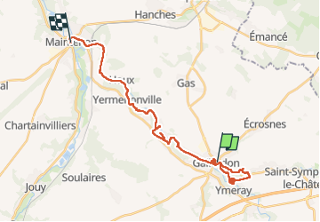
Trail Walking of 27 km to be discovered at Centre-Loire Valley, Eure-et-Loir, Gallardon. This trail is proposed by chessyca.
Description
Parcours rendu difficile par l'humidité présente sur tout le terrain. Beaucoup de branchages et de passages impossibles, tout du moins en cette saison
Le tracé est à revoir en de nombreux points
En revanche paysages magnifiques et villages très sympas
Positioning
Country:
France
Region :
Centre-Loire Valley
Department/Province :
Eure-et-Loir
Municipality :
Gallardon
Location:
Unknown
Start:(Dec)
Start:(UTM)
403322 ; 5375450 (31U) N.
Comments
Trails nearby
![Trail Walking Levainville - Levainville 12 - Photo](https://media.geolcdn.com/t/375/260/ext.jpg?maxdim=2&url=https%3A%2F%2Fstatic1.geolcdn.com%2Fsiteimages%2Fupload%2Ffiles%2F1553511878bg_sport_marche.png)
![Walking Walking](https://static1.geolcdn.com/sitytour/trail-icons/101.png)
Levainville 12
Walking
Medium
(1)
Levainville,
Centre-Loire Valley,
Eure-et-Loir,
France
![](/images/other/stat-length.png)
12.5 km | 14.5 km-effort
3h 11min
![](https://static1.geolcdn.com/siteimages/upload/files/16400158638029165_repeat_loop_refresh_sync_direction_icon.png)
Yes
![Trail On foot Gallardon - SityTrail - 4248917 - gallardonxmaintenon - Photo](https://media.geolcdn.com/t/375/260/ext.jpg?maxdim=2&url=https%3A%2F%2Fstatic1.geolcdn.com%2Fsiteimages%2Fupload%2Ffiles%2F1545311037marcheuse_200dpi.jpg)
![On foot On foot](https://static1.geolcdn.com/sitytour/trail-icons/100.png)
SityTrail - 4248917 - gallardonxmaintenon
On foot
Medium
Gallardon,
Centre-Loire Valley,
Eure-et-Loir,
France
![](/images/other/stat-length.png)
27 km | 30 km-effort
6h 43min
![](https://static1.geolcdn.com/siteimages/upload/files/16400158638029165_repeat_loop_refresh_sync_direction_icon.png)
No
![Trail Walking Gallardon - gallardon - Photo](https://media.geolcdn.com/t/375/260/ext.jpg?maxdim=2&url=https%3A%2F%2Fstatic1.geolcdn.com%2Fsiteimages%2Fupload%2Ffiles%2F1553511878bg_sport_marche.png)
![Walking Walking](https://static1.geolcdn.com/sitytour/trail-icons/101.png)
gallardon
Walking
Medium
Gallardon,
Centre-Loire Valley,
Eure-et-Loir,
France
![](/images/other/stat-length.png)
10.6 km | 11.9 km-effort
2h 46min
![](https://static1.geolcdn.com/siteimages/upload/files/16400158638029165_repeat_loop_refresh_sync_direction_icon.png)
Yes
![Trail Other activity Auneau-Bleury-Saint-Symphorien - Bleury - Photo](https://media.geolcdn.com/t/375/260/ext.jpg?maxdim=2&url=https%3A%2F%2Fstatic1.geolcdn.com%2Fsiteimages%2Fupload%2Ffiles%2F1545311037marcheuse_200dpi.jpg)
![Other activity Other activity](https://static1.geolcdn.com/sitytour/trail-icons/900.png)
Bleury
Other activity
Very easy
Auneau-Bleury-Saint-Symphorien,
Centre-Loire Valley,
Eure-et-Loir,
France
![](/images/other/stat-length.png)
9.8 km | 11.3 km-effort
2h 0min
![](https://static1.geolcdn.com/siteimages/upload/files/16400158638029165_repeat_loop_refresh_sync_direction_icon.png)
No
![Trail Other activity Auneau-Bleury-Saint-Symphorien - Bleury - Photo](https://media.geolcdn.com/t/375/260/ext.jpg?maxdim=2&url=https%3A%2F%2Fstatic1.geolcdn.com%2Fsiteimages%2Fupload%2Ffiles%2F1545311037marcheuse_200dpi.jpg)
![Other activity Other activity](https://static1.geolcdn.com/sitytour/trail-icons/900.png)
Bleury
Other activity
Very easy
Auneau-Bleury-Saint-Symphorien,
Centre-Loire Valley,
Eure-et-Loir,
France
![](/images/other/stat-length.png)
8.9 km | 10.3 km-effort
2h 0min
![](https://static1.geolcdn.com/siteimages/upload/files/16400158638029165_repeat_loop_refresh_sync_direction_icon.png)
No
![Trail Cycle Auneau-Bleury-Saint-Symphorien - avec Agnès - Photo](https://media.geolcdn.com/t/375/260/ext.jpg?maxdim=2&url=https%3A%2F%2Fstatic1.geolcdn.com%2Fsiteimages%2Fupload%2Ffiles%2F1524743154velo.jpg)
![Cycle Cycle](https://static1.geolcdn.com/sitytour/trail-icons/200.png)
avec Agnès
Cycle
Very easy
Auneau-Bleury-Saint-Symphorien,
Centre-Loire Valley,
Eure-et-Loir,
France
![](/images/other/stat-length.png)
16.3 km | 18.3 km-effort
Unknown
![](https://static1.geolcdn.com/siteimages/upload/files/16400158638029165_repeat_loop_refresh_sync_direction_icon.png)
Yes
![Trail On foot Gallardon - Gallardon-Maintenon - Photo](https://media.geolcdn.com/t/375/260/ext.jpg?maxdim=2&url=https%3A%2F%2Fstatic1.geolcdn.com%2Fsiteimages%2Fupload%2Ffiles%2F1545311037marcheuse_200dpi.jpg)
![On foot On foot](https://static1.geolcdn.com/sitytour/trail-icons/100.png)
Gallardon-Maintenon
On foot
Medium
Gallardon,
Centre-Loire Valley,
Eure-et-Loir,
France
![](/images/other/stat-length.png)
27 km | 30 km-effort
6h 43min
![](https://static1.geolcdn.com/siteimages/upload/files/16400158638029165_repeat_loop_refresh_sync_direction_icon.png)
No
![Trail Walking Gallardon - Gallardon Montlouet 9 km - Photo](https://media.geolcdn.com/t/375/260/ext.jpg?maxdim=2&url=https%3A%2F%2Fstatic1.geolcdn.com%2Fsiteimages%2Fupload%2Ffiles%2F1553511878bg_sport_marche.png)
![Walking Walking](https://static1.geolcdn.com/sitytour/trail-icons/101.png)
Gallardon Montlouet 9 km
Walking
Medium
Gallardon,
Centre-Loire Valley,
Eure-et-Loir,
France
![](/images/other/stat-length.png)
8.9 km | 10.2 km-effort
2h 26min
![](https://static1.geolcdn.com/siteimages/upload/files/16400158638029165_repeat_loop_refresh_sync_direction_icon.png)
Yes
![Trail Walking Auneau-Bleury-Saint-Symphorien - bleury 2466 - Photo](https://media.geolcdn.com/t/375/260/ext.jpg?maxdim=2&url=https%3A%2F%2Fstatic1.geolcdn.com%2Fsiteimages%2Fupload%2Ffiles%2F1553511878bg_sport_marche.png)
![Walking Walking](https://static1.geolcdn.com/sitytour/trail-icons/101.png)
bleury 2466
Walking
Medium
Auneau-Bleury-Saint-Symphorien,
Centre-Loire Valley,
Eure-et-Loir,
France
![](/images/other/stat-length.png)
10.5 km | 11.7 km-effort
2h 23min
![](https://static1.geolcdn.com/siteimages/upload/files/16400158638029165_repeat_loop_refresh_sync_direction_icon.png)
Yes