![](/images/other/stat-length.png)
![Trail Running Heillecourt - Heillecourt 10 237m +89m - Photo](https://media.geolcdn.com/t/1900/400/ext.pjpeg?maxdim=2&url=https%3A%2F%2Fstatic1.geolcdn.com%2Fsiteimages%2Fupload%2Ffiles%2F1524743154running.jpg)
Heillecourt 10 237m +89m
DanielROLLET
User
![Length](/images/other/stat-length.png)
Length
10.4 km
![Max alt](https://static1.geolcdn.com/siteimages/upload/files/1508320355ic_sort_altitude_max_24dp.png)
Max alt
234 m
![Uphill gradient](https://static1.geolcdn.com/siteimages/upload/files/1508320355ic_sort_den_pos_24dp.png)
Uphill gradient
89 m
![Km-Effort](/images/other/stat-length.png)
Km-Effort
11.6 km
![Min alt](https://static1.geolcdn.com/siteimages/upload/files/1508320355ic_sort_altitude_min_24dp.png)
Min alt
205 m
![Downhill gradient](https://static1.geolcdn.com/siteimages/upload/files/1508320355ic_sort_den_neg_24dp.png)
Downhill gradient
90 m
![Boucle](https://static1.geolcdn.com/siteimages/upload/files/16400158638029165_repeat_loop_refresh_sync_direction_icon.png)
Boucle
Yes
Creation date :
2025-01-09 08:58:58.644
Updated on :
2025-01-09 12:30:46.854
![Running](https://static1.geolcdn.com/sitytour/trail-icons/103.png)
1h35
Difficulty : Easy
![Scan this QR Code to open this trail in the SityTrail application](https://capi.geolives.com/qq0zvz2zws4bq2lad0pu/sitytour/trails/4314281/qr.png?size=200)
FREE GPS app for hiking
About
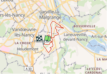
Trail Running of 10.4 km to be discovered at Grand Est, Meurthe-et-Moselle, Heillecourt. This trail is proposed by DanielROLLET.
Description
2025 01 09 Reco en footing pour MND
Pluie
Attention le sentier ne passe pas sous l'avenue Léon Songeur, le ruisseau du Moulin déborde arbres en travers. Perdu 5mn pour remonter sur la route.
Modifier le circuit par temps de forte pluie.
Positioning
Country:
France
Region :
Grand Est
Department/Province :
Meurthe-et-Moselle
Municipality :
Heillecourt
Location:
Unknown
Start:(Dec)
Start:(UTM)
293362 ; 5392338 (32U) N.
Comments
Trails nearby
![Trail Running Pulnoy - Parcours de santé PULNOY - Photo](https://media.geolcdn.com/t/375/260/ext.jpg?maxdim=2&url=https%3A%2F%2Fservices.sitytrail.com%2FGeolivesWS%2FDownloadMedia.ashx%3FTrailID%3D206190%26Media%3D20130720101848.jpg)
![Running Running](https://static1.geolcdn.com/sitytour/trail-icons/103.png)
Parcours de santé PULNOY
Running
Very easy
(1)
Pulnoy,
Grand Est,
Meurthe-et-Moselle,
France
![](/images/other/stat-length.png)
4.8 km | 6 km-effort
58min
![](https://static1.geolcdn.com/siteimages/upload/files/16400158638029165_repeat_loop_refresh_sync_direction_icon.png)
Yes
![Trail On foot Fléville-devant-Nancy - Fléville-devant-Nancy et son château - Photo](https://media.geolcdn.com/t/375/260/ee7686de-cd52-43ca-b6f5-ed4c3a349bb0.jpeg&format=jpg&maxdim=2)
![On foot On foot](https://static1.geolcdn.com/sitytour/trail-icons/100.png)
Fléville-devant-Nancy et son château
On foot
Easy
Fléville-devant-Nancy,
Grand Est,
Meurthe-et-Moselle,
France
![](/images/other/stat-length.png)
7.9 km | 9.4 km-effort
2h 8min
![](https://static1.geolcdn.com/siteimages/upload/files/16400158638029165_repeat_loop_refresh_sync_direction_icon.png)
Yes
![Trail Electric bike Fléville-devant-Nancy - tour dd moselle - Photo](https://media.geolcdn.com/t/375/260/ext.jpg?maxdim=2&url=https%3A%2F%2Fstatic1.geolcdn.com%2Fsiteimages%2Fupload%2Ffiles%2F1524743154velo.jpg)
![Electric bike Electric bike](https://static1.geolcdn.com/sitytour/trail-icons/205.png)
tour dd moselle
Electric bike
Very easy
(1)
Fléville-devant-Nancy,
Grand Est,
Meurthe-et-Moselle,
France
![](/images/other/stat-length.png)
45 km | 55 km-effort
3h 0min
![](https://static1.geolcdn.com/siteimages/upload/files/16400158638029165_repeat_loop_refresh_sync_direction_icon.png)
Yes
![Trail sport Ludres - Ludres - Photo](https://media.geolcdn.com/t/375/260/4a41c09b-4979-47d6-9e86-ddd52f153625.jpg&format=jpg&maxdim=2)
Ludres
sport
Very easy
Ludres,
Grand Est,
Meurthe-et-Moselle,
France
![](/images/other/stat-length.png)
11.6 km | 14.9 km-effort
Unknown
![](https://static1.geolcdn.com/siteimages/upload/files/16400158638029165_repeat_loop_refresh_sync_direction_icon.png)
Yes
![Trail Walking Ludres - SityTrail - Marche gourmande 11km - Photo](https://media.geolcdn.com/t/375/260/ext.jpg?maxdim=2&url=https%3A%2F%2Fstatic1.geolcdn.com%2Fsiteimages%2Fupload%2Ffiles%2F1553511878bg_sport_marche.png)
![Walking Walking](https://static1.geolcdn.com/sitytour/trail-icons/101.png)
SityTrail - Marche gourmande 11km
Walking
Difficult
(2)
Ludres,
Grand Est,
Meurthe-et-Moselle,
France
![](/images/other/stat-length.png)
10.4 km | 12.1 km-effort
2h 45min
![](https://static1.geolcdn.com/siteimages/upload/files/16400158638029165_repeat_loop_refresh_sync_direction_icon.png)
Yes
![Trail Walking Nancy - Ma dernière avant opération - Photo](https://media.geolcdn.com/t/375/260/ext.jpg?maxdim=2&url=https%3A%2F%2Fstatic1.geolcdn.com%2Fsiteimages%2Fupload%2Ffiles%2F1553511878bg_sport_marche.png)
![Walking Walking](https://static1.geolcdn.com/sitytour/trail-icons/101.png)
Ma dernière avant opération
Walking
Very difficult
(1)
Nancy,
Grand Est,
Meurthe-et-Moselle,
France
![](/images/other/stat-length.png)
22 km | 25 km-effort
4h 12min
![](https://static1.geolcdn.com/siteimages/upload/files/16400158638029165_repeat_loop_refresh_sync_direction_icon.png)
Yes
![Trail Walking Vandœuvre-lès-Nancy - Randonnée USEP 2023 - Photo](https://media.geolcdn.com/t/375/260/ext.jpg?maxdim=2&url=https%3A%2F%2Fstatic1.geolcdn.com%2Fsiteimages%2Fupload%2Ffiles%2F1553511878bg_sport_marche.png)
![Walking Walking](https://static1.geolcdn.com/sitytour/trail-icons/101.png)
Randonnée USEP 2023
Walking
Difficult
(1)
Vandœuvre-lès-Nancy,
Grand Est,
Meurthe-et-Moselle,
France
![](/images/other/stat-length.png)
11.7 km | 15.2 km-effort
3h 27min
![](https://static1.geolcdn.com/siteimages/upload/files/16400158638029165_repeat_loop_refresh_sync_direction_icon.png)
No
![Trail Walking Ludres - marche nuit - Photo](https://media.geolcdn.com/t/375/260/2c15af7e-0536-4068-be2b-216477912337.jpg&format=jpg&maxdim=2)
![Walking Walking](https://static1.geolcdn.com/sitytour/trail-icons/101.png)
marche nuit
Walking
Medium
Ludres,
Grand Est,
Meurthe-et-Moselle,
France
![](/images/other/stat-length.png)
8.7 km | 10.1 km-effort
2h 11min
![](https://static1.geolcdn.com/siteimages/upload/files/16400158638029165_repeat_loop_refresh_sync_direction_icon.png)
Yes
![Trail Walking Nancy - Ma rando du jour - Photo](https://media.geolcdn.com/t/375/260/c990ad83-2661-43f9-99e0-4498fd5d020a.jpg&format=jpg&maxdim=2)
![Walking Walking](https://static1.geolcdn.com/sitytour/trail-icons/101.png)
Ma rando du jour
Walking
Difficult
Nancy,
Grand Est,
Meurthe-et-Moselle,
France
![](/images/other/stat-length.png)
35 km | 41 km-effort
5h 55min
![](https://static1.geolcdn.com/siteimages/upload/files/16400158638029165_repeat_loop_refresh_sync_direction_icon.png)
Yes