![](/images/other/stat-length.png)
![Trail Nordic walking Ottignies-Louvain-la-Neuve - Céroux/Château de Pallandt - Photo](https://media.geolcdn.com/t/1900/400/ext.pjpeg?maxdim=2&url=https%3A%2F%2Fstatic1.geolcdn.com%2Fsiteimages%2Fupload%2Ffiles%2F1545311037marcheuse_200dpi.jpg)
Céroux/Château de Pallandt
denissculier
User
![Length](/images/other/stat-length.png)
Length
8.4 km
![Max alt](https://static1.geolcdn.com/siteimages/upload/files/1508320355ic_sort_altitude_max_24dp.png)
Max alt
137 m
![Uphill gradient](https://static1.geolcdn.com/siteimages/upload/files/1508320355ic_sort_den_pos_24dp.png)
Uphill gradient
131 m
![Km-Effort](/images/other/stat-length.png)
Km-Effort
10.2 km
![Min alt](https://static1.geolcdn.com/siteimages/upload/files/1508320355ic_sort_altitude_min_24dp.png)
Min alt
77 m
![Downhill gradient](https://static1.geolcdn.com/siteimages/upload/files/1508320355ic_sort_den_neg_24dp.png)
Downhill gradient
131 m
![Boucle](https://static1.geolcdn.com/siteimages/upload/files/16400158638029165_repeat_loop_refresh_sync_direction_icon.png)
Boucle
Yes
Creation date :
2018-02-09 00:00:00.0
Updated on :
2018-02-09 00:00:00.0
![Nordic walking](https://static1.geolcdn.com/sitytour/trail-icons/102.png)
2h03
Difficulty : Medium
![Scan this QR Code to open this trail in the SityTrail application](https://capi.geolives.com/qq0zvz2zws4bq2lad0pu/sitytour/trails/431278/qr.png?size=200)
FREE GPS app for hiking
About
Trail Nordic walking of 8.4 km to be discovered at Wallonia, Walloon Brabant, Ottignies-Louvain-la-Neuve. This trail is proposed by denissculier.
Description
De la place communale vers la chapelle ND de Lourdes, le bois des Conins, la chapelle de Palande, Bruyère del Vigne et le champ Mahau
Positioning
Country:
Belgium
Region :
Wallonia
Department/Province :
Walloon Brabant
Municipality :
Ottignies-Louvain-la-Neuve
Location:
Céroux-Mousty
Start:(Dec)
Start:(UTM)
606975 ; 5613165 (31U) N.
Comments
Trails nearby
![Trail Walking Lasne - RB-Bw-11 - Raccourci 2 - Les cinq clochers de Lasne - Photo](https://media.geolcdn.com/t/375/260/ext.jpg?maxdim=2&url=https%3A%2F%2Fservices.sitytrail.com%2FGeolivesWS%2FDownloadMedia.ashx%3FTrailID%3D220382%26Media%3De3749982-4581-4663-b0ab-732ada3b6d18.jpg)
![Walking Walking](https://static1.geolcdn.com/sitytour/trail-icons/101.png)
RB-Bw-11 - Raccourci 2 - Les cinq clochers de Lasne
Walking
Easy
(21)
Lasne,
Wallonia,
Walloon Brabant,
Belgium
![](/images/other/stat-length.png)
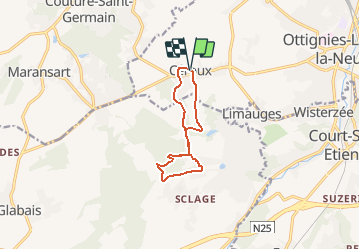
10.3 km | 12.6 km-effort
2h 46min
![](https://static1.geolcdn.com/siteimages/upload/files/16400158638029165_repeat_loop_refresh_sync_direction_icon.png)
Yes
![Trail Walking Lasne - RB-Bw-11 - Raccourci 1 - Les cinq clochers de Lasne - Photo](https://media.geolcdn.com/t/375/260/ext.jpg?maxdim=2&url=https%3A%2F%2Fservices.sitytrail.com%2FGeolivesWS%2FDownloadMedia.ashx%3FTrailID%3D220381%26Media%3Dc424c810-e3fc-4417-9a3b-ca0a22b722e1.jpg)
![Walking Walking](https://static1.geolcdn.com/sitytour/trail-icons/101.png)
RB-Bw-11 - Raccourci 1 - Les cinq clochers de Lasne
Walking
Very difficult
(9)
Lasne,
Wallonia,
Walloon Brabant,
Belgium
![](/images/other/stat-length.png)
20 km | 25 km-effort
5h 41min
![](https://static1.geolcdn.com/siteimages/upload/files/16400158638029165_repeat_loop_refresh_sync_direction_icon.png)
Yes
![Trail Walking Genappe - RB-Bw-09 Raccourci 1 & 2 - Autour de la jeune Dyle et de ses affluents - Photo](https://media.geolcdn.com/t/375/260/ext.jpg?maxdim=2&url=https%3A%2F%2Fservices.sitytrail.com%2FGeolivesWS%2FDownloadMedia.ashx%3FTrailID%3D220340%26Media%3Dd40b4c5b-4793-41f9-ac7b-fe40a955ea25.jpg)
![Walking Walking](https://static1.geolcdn.com/sitytour/trail-icons/101.png)
RB-Bw-09 Raccourci 1 & 2 - Autour de la jeune Dyle et de ses affluents
Walking
Difficult
(11)
Genappe,
Wallonia,
Walloon Brabant,
Belgium
![](/images/other/stat-length.png)
9.7 km | 12.5 km-effort
2h 50min
![](https://static1.geolcdn.com/siteimages/upload/files/16400158638029165_repeat_loop_refresh_sync_direction_icon.png)
Yes
![Trail Walking Genappe - RB-Bw-09 Raccourci 1 - Autour de la jeune Dyle et de ses affluents - Photo](https://media.geolcdn.com/t/375/260/ext.jpg?maxdim=2&url=https%3A%2F%2Fservices.sitytrail.com%2FGeolivesWS%2FDownloadMedia.ashx%3FTrailID%3D220337%26Media%3Dcacfbcff-3084-47a0-8267-9fc97c2da542.jpg)
![Walking Walking](https://static1.geolcdn.com/sitytour/trail-icons/101.png)
RB-Bw-09 Raccourci 1 - Autour de la jeune Dyle et de ses affluents
Walking
Difficult
(11)
Genappe,
Wallonia,
Walloon Brabant,
Belgium
![](/images/other/stat-length.png)
13.2 km | 16.9 km-effort
3h 49min
![](https://static1.geolcdn.com/siteimages/upload/files/16400158638029165_repeat_loop_refresh_sync_direction_icon.png)
Yes
![Trail Walking Lasne - RB-Bw-11 - Les cinq clochers de Lasne - Photo](https://media.geolcdn.com/t/375/260/ext.jpg?maxdim=2&url=https%3A%2F%2Fservices.sitytrail.com%2FGeolivesWS%2FDownloadMedia.ashx%3FTrailID%3D179586%26Media%3Dc424c810-e3fc-4417-9a3b-ca0a22b722e1.jpg)
![Walking Walking](https://static1.geolcdn.com/sitytour/trail-icons/101.png)
RB-Bw-11 - Les cinq clochers de Lasne
Walking
Medium
(12)
Lasne,
Wallonia,
Walloon Brabant,
Belgium
![](/images/other/stat-length.png)
21 km | 27 km-effort
5h 41min
![](https://static1.geolcdn.com/siteimages/upload/files/16400158638029165_repeat_loop_refresh_sync_direction_icon.png)
Yes
![Trail Walking Genappe - RB-Bw-09 - Bousval - 2025-02-08 - Photo](https://media.geolcdn.com/t/375/260/ext.jpg?maxdim=2&url=https%3A%2F%2Fservices.sitytrail.com%2FGeolivesWS%2FDownloadMedia.ashx%3FTrailID%3D179584%26Media%3Dcacfbcff-3084-47a0-8267-9fc97c2da542.jpg)
![Walking Walking](https://static1.geolcdn.com/sitytour/trail-icons/101.png)
RB-Bw-09 - Bousval - 2025-02-08
Walking
Very difficult
(9)
Genappe,
Wallonia,
Walloon Brabant,
Belgium
![](/images/other/stat-length.png)
22 km | 28 km-effort
6h 26min
![](https://static1.geolcdn.com/siteimages/upload/files/16400158638029165_repeat_loop_refresh_sync_direction_icon.png)
Yes
![Trail Walking Ottignies-Louvain-la-Neuve - RL-GG-02 - Céroux-Mousty - Villers-la-Ville - 2025-02-08 - Photo](https://media.geolcdn.com/t/375/260/2eead39d-9522-4a6a-a4f3-f791e0a7304a.jpg&format=jpg&maxdim=2)
![Walking Walking](https://static1.geolcdn.com/sitytour/trail-icons/101.png)
RL-GG-02 - Céroux-Mousty - Villers-la-Ville - 2025-02-08
Walking
Very difficult
(4)
Ottignies-Louvain-la-Neuve,
Wallonia,
Walloon Brabant,
Belgium
![](/images/other/stat-length.png)
20 km | 26 km-effort
5h 55min
![](https://static1.geolcdn.com/siteimages/upload/files/16400158638029165_repeat_loop_refresh_sync_direction_icon.png)
No
![Mountain bike Mountain bike](https://static1.geolcdn.com/sitytour/trail-icons/202.png)
maransart
Mountain bike
Difficult
(1)
Lasne,
Wallonia,
Walloon Brabant,
Belgium
![](/images/other/stat-length.png)
40 km | 49 km-effort
Unknown
![](https://static1.geolcdn.com/siteimages/upload/files/16400158638029165_repeat_loop_refresh_sync_direction_icon.png)
Yes
![Trail Walking Court-Saint-Étienne - RB-BW-08 - À la rencontre de trois vallées - Photo](https://media.geolcdn.com/t/375/260/ext.jpg?maxdim=2&url=https%3A%2F%2Fservices.sitytrail.com%2FGeolivesWS%2FDownloadMedia.ashx%3FTrailID%3D220267%26Media%3D6c86831f-6220-45af-ac63-82e6ea37f2ed.jpg)
![Walking Walking](https://static1.geolcdn.com/sitytour/trail-icons/101.png)
RB-BW-08 - À la rencontre de trois vallées
Walking
Very difficult
(2)
Court-Saint-Étienne,
Wallonia,
Walloon Brabant,
Belgium
![](/images/other/stat-length.png)
26 km | 32 km-effort
7h 18min
![](https://static1.geolcdn.com/siteimages/upload/files/16400158638029165_repeat_loop_refresh_sync_direction_icon.png)
Yes