


Duntroon 250106

JohnTompa
User
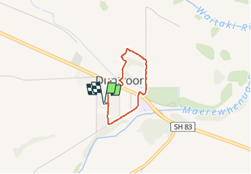

Length
2.4 km

Max alt
157 m

Uphill gradient
28 m
Km-Effort
2.7 km

Min alt
131 m

Downhill gradient
27 m
Boucle
Yes
Creation date :
2025-01-06 03:42:44.685
Updated on :
2025-01-06 05:21:58.861
1h38
Difficulty : Easy

FREE GPS app for hiking
 SityTrail
IGN / Geographical institutes
SityTrail World
The world is yours!
About
Trail Walking of 2.4 km to be discovered at Canterbury, Waitaki District. This trail is proposed by JohnTompa.
Positioning
Country:
New Zealand
Region :
Canterbury
Department/Province :
Waitaki District
Municipality :
Unknown
Location:
Unknown
Start:(Dec)
Start:(UTM)
474810 ; 5032996 (59G) S.
Comments
Trails nearby