![](/images/other/stat-length.png)
![Trail Mountain bike Boën-sur-Lignon - Boen Pommiers - Photo](https://media.geolcdn.com/t/1900/400/ext.pjpeg?maxdim=2&url=https%3A%2F%2Fservices.sitytrail.com%2FGeolivesWS%2FDownloadMedia.ashx%3FTrailID%3D430592%26Media%3Dfix__20150607094312.jpg)
Boen Pommiers
fabrixte
User
![Length](/images/other/stat-length.png)
![Max alt](https://static1.geolcdn.com/siteimages/upload/files/1508320355ic_sort_altitude_max_24dp.png)
![Uphill gradient](https://static1.geolcdn.com/siteimages/upload/files/1508320355ic_sort_den_pos_24dp.png)
![Km-Effort](/images/other/stat-length.png)
![Min alt](https://static1.geolcdn.com/siteimages/upload/files/1508320355ic_sort_altitude_min_24dp.png)
![Downhill gradient](https://static1.geolcdn.com/siteimages/upload/files/1508320355ic_sort_den_neg_24dp.png)
![Boucle](https://static1.geolcdn.com/siteimages/upload/files/16400158638029165_repeat_loop_refresh_sync_direction_icon.png)
![Mountain bike](https://static1.geolcdn.com/sitytour/trail-icons/202.png)
2h10
Difficulty : Medium
![Scan this QR Code to open this trail in the SityTrail application](https://capi.geolives.com/qq0zvz2zws4bq2lad0pu/sitytour/trails/430592/qr.png?size=200)
FREE GPS app for hiking
About
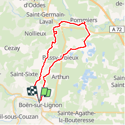
Trail Mountain bike of 28 km to be discovered at Auvergne-Rhône-Alpes, Loire, Boën-sur-Lignon. This trail is proposed by fabrixte.
Description
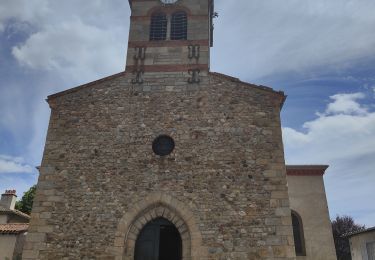
Sortie VTT organisée par la classe de CM1 de l'école publique de Boën. Départ et arrivée depuis l'école. Passage par la réservoir du Guet (à pied), puis le Guet.
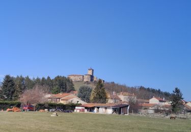
Ravitaillement en eau : intersection rue des pelouses - chemin de terre. Le Bas Montcel, GoutteBelin, Croye, le Bost, Verrières. Ravitaillement en eau : La commanderie. Pertuizet, le chemin de terre permet de rejoindre le camping de Pommiers. Pique nique à proximité du terrain de foot (toilettes, bancs, jeux).
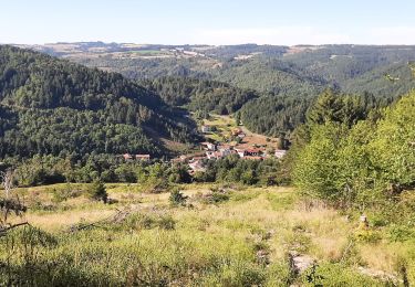
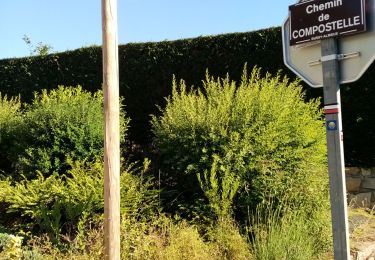
Après-midi : les Pierrats, chemin de compostelle. Arret ravitaillement : village de Bussy (fin du chemin de terre). Traversée de RD8, Reprise du chemin de Compostelle en direction des Trouillères. Arret à la fin de la forêt (boissons).
Attention aux chemins pour rejoindre l'Annet (pente, herbes hautes...). Descente par la rue de St Sixte. Arrivée sur le parking de la maternelle.
Positioning
Comments
Trails nearby
![Trail Walking Débats-Rivière-d'Orpra - Débats Riviere d'Orpra - Photo](https://media.geolcdn.com/t/375/260/ext.jpg?maxdim=2&url=https%3A%2F%2Fservices.sitytrail.com%2FGeolivesWS%2FDownloadMedia.ashx%3FTrailID%3D558460%26Media%3Dfix__20160424122259.jpg)
![Walking Walking](https://static1.geolcdn.com/sitytour/trail-icons/101.png)
Walking
![](/images/other/stat-length.png)
![](https://static1.geolcdn.com/siteimages/upload/files/16400158638029165_repeat_loop_refresh_sync_direction_icon.png)
![Trail Walking Trelins - De la cave à la grotte aux fées - Photo](https://media.geolcdn.com/t/375/260/ext.jpg?maxdim=2&url=https%3A%2F%2Fservices.sitytrail.com%2FGeolivesWS%2FDownloadMedia.ashx%3FTrailID%3D425481%26Media%3Dfix__20150525083011.jpg)
![Walking Walking](https://static1.geolcdn.com/sitytour/trail-icons/101.png)
Walking
![](/images/other/stat-length.png)
![](https://static1.geolcdn.com/siteimages/upload/files/16400158638029165_repeat_loop_refresh_sync_direction_icon.png)
![Trail Walking Marcoux - Ballade au volcan Montaubourg - Photo](https://media.geolcdn.com/t/375/260/94a6a3b0-46f4-4451-8f89-d174373ac48b.jpg&format=jpg&maxdim=2)
![Walking Walking](https://static1.geolcdn.com/sitytour/trail-icons/101.png)
Walking
![](/images/other/stat-length.png)
![](https://static1.geolcdn.com/siteimages/upload/files/16400158638029165_repeat_loop_refresh_sync_direction_icon.png)
![Trail Walking Leigneux - Randonnée au dessus de Leigneux - Photo](https://media.geolcdn.com/t/375/260/13d032b6-6aea-42ea-8497-6096a48a5cf2.jpg&format=jpg&maxdim=2)
![Walking Walking](https://static1.geolcdn.com/sitytour/trail-icons/101.png)
Walking
![](/images/other/stat-length.png)
![](https://static1.geolcdn.com/siteimages/upload/files/16400158638029165_repeat_loop_refresh_sync_direction_icon.png)
![Trail Walking Boën-sur-Lignon - Randonnée entre Boen et Sail sous Couzan - Photo](https://media.geolcdn.com/t/375/260/7e52e5e8-b1b1-402e-8e13-e37644c63017.jpg&format=jpg&maxdim=2)
![Walking Walking](https://static1.geolcdn.com/sitytour/trail-icons/101.png)
Walking
![](/images/other/stat-length.png)
![](https://static1.geolcdn.com/siteimages/upload/files/16400158638029165_repeat_loop_refresh_sync_direction_icon.png)
![Trail Walking Montverdun - Randonnée autour de Montverdun - Photo](https://media.geolcdn.com/t/375/260/64d529f3-750c-4edd-b848-97cd9687592e.jpg&format=jpg&maxdim=2)
![Walking Walking](https://static1.geolcdn.com/sitytour/trail-icons/101.png)
Walking
![](/images/other/stat-length.png)
![](https://static1.geolcdn.com/siteimages/upload/files/16400158638029165_repeat_loop_refresh_sync_direction_icon.png)
![Trail Walking Débats-Rivière-d'Orpra - Cascade de Débats-Rivière d'Orpra - Photo](https://media.geolcdn.com/t/375/260/eb98c35b-5864-4e82-8717-127db429c0d9.jpg&format=jpg&maxdim=2)
![Walking Walking](https://static1.geolcdn.com/sitytour/trail-icons/101.png)
Walking
![](/images/other/stat-length.png)
![](https://static1.geolcdn.com/siteimages/upload/files/16400158638029165_repeat_loop_refresh_sync_direction_icon.png)
![Trail Walking Bussy-Albieux - rando au départ de Bussy Albieux - Photo](https://media.geolcdn.com/t/375/260/1eea7c6f-50ba-409b-b185-5ebc59a50053.jpg&format=jpg&maxdim=2)
![Walking Walking](https://static1.geolcdn.com/sitytour/trail-icons/101.png)
Walking
![](/images/other/stat-length.png)
![](https://static1.geolcdn.com/siteimages/upload/files/16400158638029165_repeat_loop_refresh_sync_direction_icon.png)
![Trail On foot Sail-sous-Couzan - Le couzan - Photo](https://media.geolcdn.com/t/375/260/ext.jpg?maxdim=2&url=https%3A%2F%2Fstatic1.geolcdn.com%2Fsiteimages%2Fupload%2Ffiles%2F1545311037marcheuse_200dpi.jpg)
![On foot On foot](https://static1.geolcdn.com/sitytour/trail-icons/100.png)
On foot
![](/images/other/stat-length.png)
![](https://static1.geolcdn.com/siteimages/upload/files/16400158638029165_repeat_loop_refresh_sync_direction_icon.png)