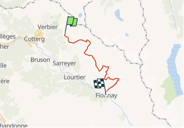
![](/images/other/stat-length.png)
![Trail Walking Val de Bagnes - Chamois 2 - Photo](https://media.geolcdn.com/t/1900/400/ext.pjpeg?maxdim=2&url=https%3A%2F%2Fstatic1.geolcdn.com%2Fsiteimages%2Fupload%2Ffiles%2F1553511878bg_sport_marche.png)
Chamois 2
verbier
User
![Length](/images/other/stat-length.png)
![Max alt](https://static1.geolcdn.com/siteimages/upload/files/1508320355ic_sort_altitude_max_24dp.png)
![Uphill gradient](https://static1.geolcdn.com/siteimages/upload/files/1508320355ic_sort_den_pos_24dp.png)
![Km-Effort](/images/other/stat-length.png)
![Min alt](https://static1.geolcdn.com/siteimages/upload/files/1508320355ic_sort_altitude_min_24dp.png)
![Downhill gradient](https://static1.geolcdn.com/siteimages/upload/files/1508320355ic_sort_den_neg_24dp.png)
![Boucle](https://static1.geolcdn.com/siteimages/upload/files/16400158638029165_repeat_loop_refresh_sync_direction_icon.png)
![Walking](https://static1.geolcdn.com/sitytour/trail-icons/101.png)
7h45
Difficulty : Unknown
![Scan this QR Code to open this trail in the SityTrail application](https://capi.geolives.com/qq0zvz2zws4bq2lad0pu/sitytour/trails/43045/qr.png?size=200)
FREE GPS app for hiking
About
Trail Walking of 15.9 km to be discovered at Valais/Wallis, Entremont, Val de Bagnes. This trail is proposed by verbier.
Description
Der Weg beginnt an der Mont-Fort-Hütte, Sie können aber auch direkt von Les Ruinettes (Bergstation der Seilbahn) oder von La Chaux aus wandern. Zunächst geht?s über steinige Geröllhalden und grüne Abhänge und nach eini-gen luftigen Passagen (für nicht schwindelfreie Wanderer kein ungetrübtes Ver-gnügen) gelangt man zum Col Termin. Der Pass bildet das Tor zum König-reich der Steinböcke und bietet eine prächtige Aussicht auf die umliegenden Gebirgsmassive. Danach fällt der Pfad gemächlich ab zur Hütte (2250 m) und ihrer Sonnenterrasse. Von Louvie aus steigt man Richtung Bec d?Aigle auf 2567 m auf. Ein abschüssiger Weg führt über Sovereu hin-unter ins Dorf Fionnay.
Positioning
Comments
Trails nearby
![Trail Walking Nendaz - lac Cleuson - cabane St Laurent - Photo](https://media.geolcdn.com/t/375/260/ext.jpg?maxdim=2&url=https%3A%2F%2Fservices.sitytrail.com%2FGeolivesWS%2FDownloadMedia.ashx%3FTrailID%3D588128%26Media%3Dfix__20160623091705.jpg)
![Walking Walking](https://static1.geolcdn.com/sitytour/trail-icons/101.png)
Walking
![](/images/other/stat-length.png)
![](https://static1.geolcdn.com/siteimages/upload/files/16400158638029165_repeat_loop_refresh_sync_direction_icon.png)
![Trail On foot Val de Bagnes - Ancien Bisse du Levron - Photo](https://media.geolcdn.com/t/375/260/80610014-2440-48cc-bb45-b16896750006.jpeg&format=jpg&maxdim=2)
![On foot On foot](https://static1.geolcdn.com/sitytour/trail-icons/100.png)
On foot
![](/images/other/stat-length.png)
![](https://static1.geolcdn.com/siteimages/upload/files/16400158638029165_repeat_loop_refresh_sync_direction_icon.png)
![Trail On foot Val de Bagnes - Col Termin-Louvie - Photo](https://media.geolcdn.com/t/375/260/5fd2d0df-c707-4ac6-b9ec-327205fb196f.jpeg&format=jpg&maxdim=2)
![On foot On foot](https://static1.geolcdn.com/sitytour/trail-icons/100.png)
On foot
![](/images/other/stat-length.png)
![](https://static1.geolcdn.com/siteimages/upload/files/16400158638029165_repeat_loop_refresh_sync_direction_icon.png)
![Trail Walking Val de Bagnes - La Haute Route : J2 - Photo](https://media.geolcdn.com/t/375/260/180b2b28-d72b-4e1f-bcdd-fa58e937cbf2.jpg&format=jpg&maxdim=2)
![Walking Walking](https://static1.geolcdn.com/sitytour/trail-icons/101.png)
Walking
![](/images/other/stat-length.png)
![](https://static1.geolcdn.com/siteimages/upload/files/16400158638029165_repeat_loop_refresh_sync_direction_icon.png)
![Trail On foot Val de Bagnes - Promenade de la Dranse - Photo](https://media.geolcdn.com/t/375/260/086adfed-46f4-4991-8417-75cd394f8ae1.jpeg&format=jpg&maxdim=2)
![On foot On foot](https://static1.geolcdn.com/sitytour/trail-icons/100.png)
On foot
![](/images/other/stat-length.png)
![](https://static1.geolcdn.com/siteimages/upload/files/16400158638029165_repeat_loop_refresh_sync_direction_icon.png)
![Trail On foot Val de Bagnes - Bruson - Moay - Photo](https://media.geolcdn.com/t/375/260/086adfed-46f4-4991-8417-75cd394f8ae1.jpeg&format=jpg&maxdim=2)
![On foot On foot](https://static1.geolcdn.com/sitytour/trail-icons/100.png)
On foot
![](/images/other/stat-length.png)
![](https://static1.geolcdn.com/siteimages/upload/files/16400158638029165_repeat_loop_refresh_sync_direction_icon.png)
![Trail Walking Val de Bagnes - CHX ZRMT Étape 4 de Cabane de Louvie à Cabane de Prafleuri - Photo](https://media.geolcdn.com/t/375/260/ext.jpg?maxdim=2&url=https%3A%2F%2Fservices.sitytrail.com%2FGeolivesWS%2FDownloadMedia.ashx%3FTrailID%3D635931%26Media%3Dfix__20160916164452.jpg)
![Walking Walking](https://static1.geolcdn.com/sitytour/trail-icons/101.png)
Walking
![](/images/other/stat-length.png)
![](https://static1.geolcdn.com/siteimages/upload/files/16400158638029165_repeat_loop_refresh_sync_direction_icon.png)
![Trail Walking Riddes - Croix de Coeur - Pierre Avoi - Photo](https://media.geolcdn.com/t/375/260/ext.jpg?maxdim=2&url=https%3A%2F%2Fstatic1.geolcdn.com%2Fsiteimages%2Fupload%2Ffiles%2F1553511878bg_sport_marche.png)
![Walking Walking](https://static1.geolcdn.com/sitytour/trail-icons/101.png)
Walking
![](/images/other/stat-length.png)
![](https://static1.geolcdn.com/siteimages/upload/files/16400158638029165_repeat_loop_refresh_sync_direction_icon.png)
![Trail sport Nendaz - 20240911 Siviez dent de Nendaz - Photo](https://media.geolcdn.com/t/375/260/7cc208c3-4203-45a5-b462-97798973a175.jpg&format=jpg&maxdim=2)
sport
![](/images/other/stat-length.png)
![](https://static1.geolcdn.com/siteimages/upload/files/16400158638029165_repeat_loop_refresh_sync_direction_icon.png)