![](/images/other/stat-length.png)
![Trail Walking Saint-Michel-sur-Orge - Saint-Michel-sur-Orge - Vallées de l'Orge et de la Boële - Photo](https://media.geolcdn.com/t/1900/400/6610ed3c-baf9-4beb-9542-36ec928dfe3d.jpg&format=pjpeg&maxdim=2)
Saint-Michel-sur-Orge - Vallées de l'Orge et de la Boële
guydu41
User
![Length](/images/other/stat-length.png)
![Max alt](https://static1.geolcdn.com/siteimages/upload/files/1508320355ic_sort_altitude_max_24dp.png)
![Uphill gradient](https://static1.geolcdn.com/siteimages/upload/files/1508320355ic_sort_den_pos_24dp.png)
![Km-Effort](/images/other/stat-length.png)
![Min alt](https://static1.geolcdn.com/siteimages/upload/files/1508320355ic_sort_altitude_min_24dp.png)
![Downhill gradient](https://static1.geolcdn.com/siteimages/upload/files/1508320355ic_sort_den_neg_24dp.png)
![Boucle](https://static1.geolcdn.com/siteimages/upload/files/16400158638029165_repeat_loop_refresh_sync_direction_icon.png)
![Walking](https://static1.geolcdn.com/sitytour/trail-icons/101.png)
2h42
Difficulty : Medium
![Scan this QR Code to open this trail in the SityTrail application](https://capi.geolives.com/qq0zvz2zws4bq2lad0pu/sitytour/trails/4303796/qr.png?size=200)
FREE GPS app for hiking
About
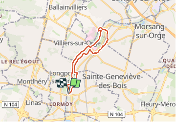
Trail Walking of 10.7 km to be discovered at Ile-de-France, Essonne, Saint-Michel-sur-Orge. This trail is proposed by guydu41.
Description
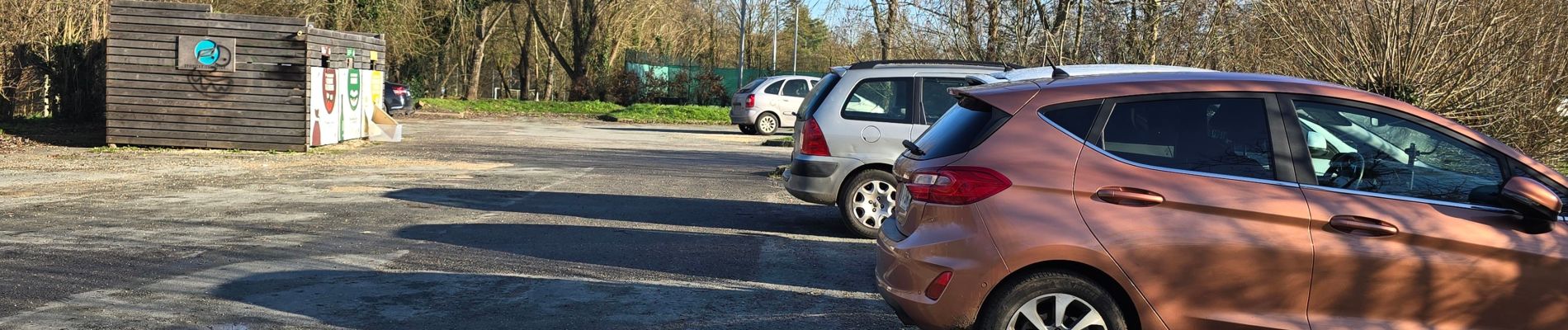
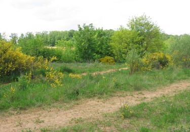
Ce circuit en sens horaire emprunte de nombreux chemins et sentiers boisés. Il commence depuis le Parking Vallée de l'Orge, Rue de Montlhéry, 91240 Saint-Michel-sur-Orge au Sud du bassin de Saint-Michel.
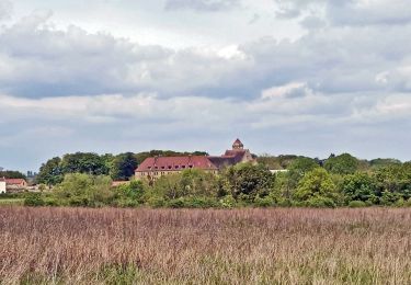
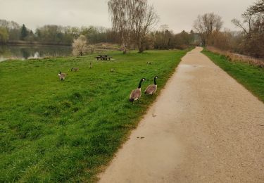
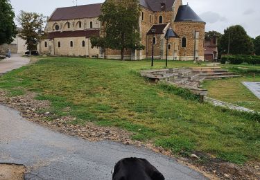
Il longe le bassin de Saint-Michel puis chemine entre les bassins de Lormoy et de Longpont avec plusieurs points de vue sur le château de Lormoy.
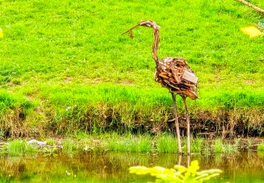
Il passe à proximité d'une sculpture en bois "Dame Hodierne" en hommage à Hodierne de Gometz épouse de Gui Ier de Montlhéry.
Il longe la rivière l'Orge, quitte le Parc de Lormoy, traverse la rivière pour rentrer dans le Parc naturel du Perray.
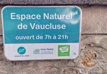
Ensuite il quitte le parc pour rentrer dans l'Espace naturel de Vaucluse et longe le cours d'eau "La Boële" jusqu'au Bassin du Breuil qu'il contourne.
Il passe au-dessus d'une importante voie ferrée, rentre dans le Bois des Genoux Blancs qu'il quitte jusqu'à la gare de Sainte-Geneviève-des-Bois.
A la gare, il emprunte une impressionnante passerelle avec une très belle vue sur la vallée de l'Orge au-dessus de la voie ferrée.
Il rejoint le Parc du Perray puis le Parc de Lormoy en longeant La Boële jusqu'au parking de départ.
Positioning
Comments
Trails nearby
![Trail Walking Ballainvilliers - GRP CV-IDF 2023 - Photo](https://media.geolcdn.com/t/375/260/0b5967b2-2c8e-4675-a0f7-553186b66225.jpg&format=jpg&maxdim=2)
![Walking Walking](https://static1.geolcdn.com/sitytour/trail-icons/101.png)
Walking
![](/images/other/stat-length.png)
![](https://static1.geolcdn.com/siteimages/upload/files/16400158638029165_repeat_loop_refresh_sync_direction_icon.png)
![Trail Walking Marcoussis - Autour de Leuville sur Orge - Photo](https://media.geolcdn.com/t/375/260/ext.jpg?maxdim=2&url=https%3A%2F%2Fservices.sitytrail.com%2FGeolivesWS%2FDownloadMedia.ashx%3FTrailID%3D105827%26Media%3D9782_6.jpg)
![Walking Walking](https://static1.geolcdn.com/sitytour/trail-icons/101.png)
Walking
![](/images/other/stat-length.png)
![](https://static1.geolcdn.com/siteimages/upload/files/16400158638029165_repeat_loop_refresh_sync_direction_icon.png)
![Trail Walking Saulx-les-Chartreux - Saulx les Chartreux vers Ville du Bois - Photo](https://media.geolcdn.com/t/375/260/ext.jpg?maxdim=2&url=https%3A%2F%2Fservices.sitytrail.com%2FGeolivesWS%2FDownloadMedia.ashx%3FTrailID%3D103772%26Media%3D6532_3.jpg)
![Walking Walking](https://static1.geolcdn.com/sitytour/trail-icons/101.png)
Walking
![](/images/other/stat-length.png)
![](https://static1.geolcdn.com/siteimages/upload/files/16400158638029165_repeat_loop_refresh_sync_direction_icon.png)
![Trail Walking Brétigny-sur-Orge - Boucle Bretigny - Arpajon - Photo](https://media.geolcdn.com/t/375/260/610d9a07-a424-4037-8ef6-13d7a5819263.jpg&format=jpg&maxdim=2)
![Walking Walking](https://static1.geolcdn.com/sitytour/trail-icons/101.png)
Walking
![](/images/other/stat-length.png)
![](https://static1.geolcdn.com/siteimages/upload/files/16400158638029165_repeat_loop_refresh_sync_direction_icon.png)
![Trail On foot Morsang-sur-Orge - Boucle 20 km Morsang sur Orge - Photo](https://media.geolcdn.com/t/375/260/d37a7650-c254-47eb-95bf-21850c3f3dae.jpg&format=jpg&maxdim=2)
![On foot On foot](https://static1.geolcdn.com/sitytour/trail-icons/100.png)
On foot
![](/images/other/stat-length.png)
![](https://static1.geolcdn.com/siteimages/upload/files/16400158638029165_repeat_loop_refresh_sync_direction_icon.png)
![Trail Walking Longpont-sur-Orge - SityTrail - Bassins du Carouge-Longpont sur Orge - Photo](https://media.geolcdn.com/t/375/260/ext.jpg?maxdim=2&url=https%3A%2F%2Fstatic1.geolcdn.com%2Fsiteimages%2Fupload%2Ffiles%2F1553511878bg_sport_marche.png)
![Walking Walking](https://static1.geolcdn.com/sitytour/trail-icons/101.png)
Walking
![](/images/other/stat-length.png)
![](https://static1.geolcdn.com/siteimages/upload/files/16400158638029165_repeat_loop_refresh_sync_direction_icon.png)
![Trail Walking Brétigny-sur-Orge - Brétigny-sur-Orge - Parcs Bassins Basilique Châteaux - Photo](https://media.geolcdn.com/t/375/260/fd995b62-46d1-489c-930d-82cafef76988.jpg&format=jpg&maxdim=2)
![Walking Walking](https://static1.geolcdn.com/sitytour/trail-icons/101.png)
Walking
![](/images/other/stat-length.png)
![](https://static1.geolcdn.com/siteimages/upload/files/16400158638029165_repeat_loop_refresh_sync_direction_icon.png)
![Trail Walking Saint-Michel-sur-Orge - Le long de l'Orge et de la Boëlle - Photo](https://media.geolcdn.com/t/375/260/6fb198f3-1073-4053-b5c8-a51bd123adfe.jpg&format=jpg&maxdim=2)
![Walking Walking](https://static1.geolcdn.com/sitytour/trail-icons/101.png)
Walking
![](/images/other/stat-length.png)
![](https://static1.geolcdn.com/siteimages/upload/files/16400158638029165_repeat_loop_refresh_sync_direction_icon.png)
![Trail Walking Longpont-sur-Orge - longpont/orge - Photo](https://media.geolcdn.com/t/375/260/7647bcc1-a830-46e0-b133-bbcf4da4f851.jpg&format=jpg&maxdim=2)
![Walking Walking](https://static1.geolcdn.com/sitytour/trail-icons/101.png)
Walking
![](/images/other/stat-length.png)
![](https://static1.geolcdn.com/siteimages/upload/files/16400158638029165_repeat_loop_refresh_sync_direction_icon.png)