![Trail Running Unknown - MALAISIE_Bord DeMerTour - Photo](https://media.geolcdn.com/t/1900/400/ext.pjpeg?maxdim=2&url=https%3A%2F%2Fstatic1.geolcdn.com%2Fsiteimages%2Fupload%2Ffiles%2F1524743154running.jpg)
MALAISIE_Bord DeMerTour
fredhd25
User
![Length](/images/other/stat-length.png)
Length
10.9 km
![Max alt](https://static1.geolcdn.com/siteimages/upload/files/1508320355ic_sort_altitude_max_24dp.png)
Max alt
15 m
![Uphill gradient](https://static1.geolcdn.com/siteimages/upload/files/1508320355ic_sort_den_pos_24dp.png)
Uphill gradient
85 m
![Km-Effort](/images/other/stat-length.png)
Km-Effort
12 km
![Min alt](https://static1.geolcdn.com/siteimages/upload/files/1508320355ic_sort_altitude_min_24dp.png)
Min alt
0 m
![Downhill gradient](https://static1.geolcdn.com/siteimages/upload/files/1508320355ic_sort_den_neg_24dp.png)
Downhill gradient
91 m
![Boucle](https://static1.geolcdn.com/siteimages/upload/files/16400158638029165_repeat_loop_refresh_sync_direction_icon.png)
Boucle
No
Creation date :
2024-12-24 10:27:59.034
Updated on :
2024-12-24 10:29:30.611
![Running](https://static1.geolcdn.com/sitytour/trail-icons/103.png)
0m
Difficulty : Easy
![Scan this QR Code to open this trail in the SityTrail application](https://capi.geolives.com/qq0zvz2zws4bq2lad0pu/sitytour/trails/4302661/qr.png?size=200)
FREE GPS app for hiking
About
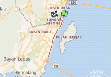
Trail Running of 10.9 km to be discovered at Penang, Southwest Penang Island District. This trail is proposed by fredhd25.
Positioning
Country:
Malaysia
Region :
Penang
Department/Province :
Southwest Penang Island District
Municipality :
Unknown
Location:
Unknown
Start:(Dec)
Start:(UTM)
644960 ; 590091 (47N) N.
Comments
Trails nearby