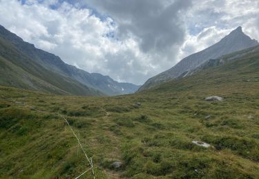
Trail Walking Bourg-Saint-Pierre - Tour du Saint-Bernard - Photo
 verbier
verbier

User

© OpenStreetMap contributors
Length
Length
85 km
Max alt
Max alt
2920 m
Uphill gradient
Uphill gradient
5905 m
Km-Effort
Km-Effort  
163 km
Min alt
Min alt
1255 m
Downhill gradient
Downhill gradient
5891 m
Boucle
Boucle
Yes
Creation date :
2014-12-10 00:00:00.0
Updated on :
2014-12-10 00:00:00.0

(0 Reviews)

Walking
Walking
36h00
Difficulty : Unknown

Scan this QR Code to open this trail in the SityTrail application

FREE GPS app for hiking

Logo SityTrail SityTrail

IGN / Geographical institutes

Download SityTrail from the App Store Download SityTrail from Google Play

Logo SityTrail SityTrail World

The world is yours!

Download SityTrail from the App Store Download SityTrail from Google Play Download SityTrail on Huawei AppGallery

About

Trail Walking of 85 km to be discovered at Valais/Wallis, Entremont, Bourg-Saint-Pierre. This trail is proposed by verbier.

Description

Start from Bg-St-Pierre, in direction of the Gd-St-Bernard pass. A night at the pass, in the company of the St-Bernards.

The 2nd day will take you to Italy, with a night at the Bonatty hut, or in Lavachey. Wild landscapes during the crossing to the Malatra pass (2900m).

Back in Switzerland for the 3rd day, with the entry by the Gd-Col-Ferret, and stretch towards La Peule.

Steep ascent to the Basset pass for the 4th day. Then, downhill slope in the Combe de l’A and its natural reserve. Night in “La Tsissette”.

The following day, stretch towards Liddes, and quite long ascent to the Mille hut.

Last stage with the descent towards Bg-St-Pierre. Optional crossing to the Mt-Rogneux.

More informations on www.tourdusaintbernard.com

Elevation profile

Points of interest

Point of interest Bourg-Saint-Pierre - Hospice du Grand-Saint-Bernard - Photo
verbier
BOURG-SAINT-PIERRE 
Point of interest Courmayeur - Refuge Bonatti - Photo
verbier
COURMAYEUR 
Point of interest Orsières - Alpage de la Peulaz - Photo
verbier
Point of interest Orsières - La Fouly - Photo
verbier
ORSIÈRES 
Point of interest Liddes - Cabane de Mille - Photo
verbier

Positioning

Country:
Switzerland
Region :
Valais/Wallis
Department/Province :
Entremont
Municipality :
Bourg-Saint-Pierre
Location:
Unknown
Start:(UTM)
361122 ; 5090229 (32T) N.

Trails nearby

Trail Walking Liddes - Combe de l’A - Photo
Walking
michauxpaul

Walking

Medium
Liddes, Valais/Wallis, Entremont, Switzerland
6.8 km | 12 km-effort
3h 27min
No
Trail Walking Liddes - vs_hike680c - Photo
Walking
GUIDE+

Walking

Very easy
Liddes, Valais/Wallis, Entremont, Switzerland
10.7 km | 23 km-effort
4h 6min
No
Trail Walking Liddes - Liddes, Bec Rond - Photo
Walking
rpf

Walking

Very easy
Liddes, Valais/Wallis, Entremont, Switzerland
7.5 km | 14.9 km-effort
4h 30min
Yes
Trail Walking Bourg-Saint-Pierre - Tour des Combins - Photo
Walking
rpf

Walking

Very easy
Bourg-Saint-Pierre, Valais/Wallis, Entremont, Switzerland
97 km | 180 km-effort
43h 16min
Yes
Trail Walking Bourg-Saint-Pierre - Bourg-St-Pierre, Cabane du Vélan - Photo
Walking
rpf

Walking

Very easy
Bourg-Saint-Pierre, Valais/Wallis, Entremont, Switzerland
9.5 km | 19.8 km-effort
5h 30min
Yes
Trail Walking Bourg-Saint-Pierre - Bourg-St-Pierre, Becca Colinte - Photo
Walking
rpf

Walking

Very easy
Bourg-Saint-Pierre, Valais/Wallis, Entremont, Switzerland
5 km | 10.5 km-effort
2h 30min
Yes
Trail Snowshoes Liddes - Liddes, Sentier Raquettes n° 12, Plan Beu  - Photo
Snowshoes
verbier

Snowshoes

Very easy
Liddes, Valais/Wallis, Entremont, Switzerland
9.1 km | 16.2 km-effort
5h 0min
Yes
Trail Snowshoes Bourg-Saint-Pierre - Bourg-St-Pierre, Sentier Raquettes n° 9, L''Oratoire - Photo
Snowshoes
verbier

Snowshoes

Very easy
Bourg-Saint-Pierre, Valais/Wallis, Entremont, Switzerland
7.2 km | 9.8 km-effort
3h 0min
No
Trail Snowshoes Liddes - Liddes, Sentier Raquettes n° 8, Les Daims  - Photo
Snowshoes
verbier

Snowshoes

Very easy
Liddes, Valais/Wallis, Entremont, Switzerland
3.6 km | 5.6 km-effort
1h 20min
Yes


Close
My subscriptions