Trail Walking Liddes - Combe de l''A - Photo
 verbier
verbier

User

© OpenStreetMap contributors
Length
Length
10.3 km
Max alt
Max alt
2719 m
Uphill gradient
Uphill gradient
1124 m
Km-Effort
Km-Effort  
22 km
Min alt
Min alt
1609 m
Downhill gradient
Downhill gradient
43 m
Boucle
Boucle
No
Creation date :
2014-12-10 00:00:00.0
Updated on :
2014-12-10 00:00:00.0

(0 Reviews)

Walking
Walking
3h55
Difficulty : Unknown

Scan this QR Code to open this trail in the SityTrail application

FREE GPS app for hiking

Logo SityTrail SityTrail

IGN / Geographical institutes

Download SityTrail from the App Store Download SityTrail from Google Play

Logo SityTrail SityTrail World

The world is yours!

Download SityTrail from the App Store Download SityTrail from Google Play Download SityTrail on Huawei AppGallery

About

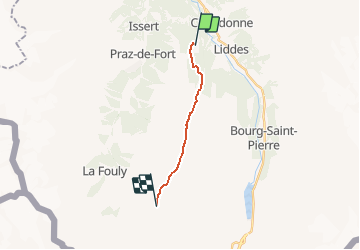
Trail Walking of 10.3 km to be discovered at Valais/Wallis, Entremont, Liddes. This trail is proposed by verbier.

Description

Start from the parking of the Vichères-Bavon lift. Take the forest road to the north and pass through the little hamlet called “Le Chapelet”. From there, follow the Bisse de la Tour, recently reconditioned, as far as the mountain stream. Cross it, and take the normal path to La Tsisette. From there start the pass which take you to the Névé de la Rousse path, passing by the high mountain pasture “La Vouasse”. Go back down from the path by the same way.

Elevation profile

Points of interest

Point of interest Liddes - Vichères - Photo
verbier
LIDDES 

Positioning

Country:
Switzerland
Region :
Valais/Wallis
Department/Province :
Entremont
Municipality :
Liddes
Location:
Unknown
Start:(UTM)
357645 ; 5094975 (32T) N.

Trails nearby

Trail On foot Liddes - Chemins pédestre, commune de Liddes - Photo
On foot
GUIDE+

On foot

Easy
Liddes, Valais/Wallis, Entremont, Switzerland
4.3 km | 6.4 km-effort
1h 27min
No
Trail On foot Orsières - sentier du Devin - Photo
On foot
GUIDE+

On foot

Easy
Orsières, Valais/Wallis, Entremont, Switzerland
3.9 km | 6.7 km-effort
1h 31min
Yes
Trail On foot Liddes - Chemins pédestre de montagne, région Orsières - Photo
On foot
GUIDE+

On foot

Easy
Liddes, Valais/Wallis, Entremont, Switzerland
6.7 km | 9.9 km-effort
2h 14min
No
Trail Walking Liddes - Combe de l’A - Photo
Walking
michauxpaul

Walking

Medium
Liddes, Valais/Wallis, Entremont, Switzerland
6.8 km | 12 km-effort
3h 27min
No
Trail On foot Orsières - Raccard du blé - Photo
On foot
GUIDE+

On foot

Easy
Orsières, Valais/Wallis, Entremont, Switzerland
7.9 km | 13.7 km-effort
3h 6min
Yes
Trail Snowshoes Orsières - Champex Lac - La Breya - Champex Lac - Photo
Snowshoes
jpksenicz

Snowshoes

Medium
Orsières, Valais/Wallis, Entremont, Switzerland
8.8 km | 18.2 km-effort
3h 1min
Yes
Trail Walking Liddes - CMX ZRMT ÉTAPE 3 de Cabane de Mille à Cabane de Louvie.  - Photo
Walking
jeff2

Walking

Easy
Liddes, Valais/Wallis, Entremont, Switzerland
18.6 km | 35 km-effort
7h 13min
No
Trail Walking Orsières - CMX ZRMT Étape 2 Champex Cabane de Mille  - Photo
Walking
jeff2

Walking

Medium
Orsières, Valais/Wallis, Entremont, Switzerland
17.9 km | 38 km-effort
7h 15min
No
Trail Walking Orsières - tmb2024 étape 7  - Photo
Walking
marcagif

Walking

Easy
Orsières, Valais/Wallis, Entremont, Switzerland
15.1 km | 26 km-effort
7h 16min
No


Close
My subscriptions