![](/images/other/stat-length.png)
![Trail Walking Buhy - De Buchet à Magny en Vexin - Photo](https://media.geolcdn.com/t/1900/400/1020b94f-166d-40ac-8266-f51a3f0e5d45.jpg&format=pjpeg&maxdim=2)
De Buchet à Magny en Vexin
chessyca
User GUIDE
![Length](/images/other/stat-length.png)
Length
25 km
![Max alt](https://static1.geolcdn.com/siteimages/upload/files/1508320355ic_sort_altitude_max_24dp.png)
Max alt
201 m
![Uphill gradient](https://static1.geolcdn.com/siteimages/upload/files/1508320355ic_sort_den_pos_24dp.png)
Uphill gradient
360 m
![Km-Effort](/images/other/stat-length.png)
Km-Effort
29 km
![Min alt](https://static1.geolcdn.com/siteimages/upload/files/1508320355ic_sort_altitude_min_24dp.png)
Min alt
59 m
![Downhill gradient](https://static1.geolcdn.com/siteimages/upload/files/1508320355ic_sort_den_neg_24dp.png)
Downhill gradient
343 m
![Boucle](https://static1.geolcdn.com/siteimages/upload/files/16400158638029165_repeat_loop_refresh_sync_direction_icon.png)
Boucle
No
Creation date :
2024-12-02 08:23:20.568
Updated on :
2024-12-02 18:49:56.642
![Walking](https://static1.geolcdn.com/sitytour/trail-icons/101.png)
5h03
Difficulty : Medium
![Scan this QR Code to open this trail in the SityTrail application](https://capi.geolives.com/qq0zvz2zws4bq2lad0pu/sitytour/trails/4286721/qr.png?size=200)
FREE GPS app for hiking
About
Trail Walking of 25 km to be discovered at Ile-de-France, Val-d'Oise, Buhy. This trail is proposed by chessyca.
Description
Rando de Jjl pour le Rif
quelques beaux villages du vexin et des étendues à perte de vue
Bus 95-04 depuis Cergy saint Christophe à l'aller comme au retour
Positioning
Country:
France
Region :
Ile-de-France
Department/Province :
Val-d'Oise
Municipality :
Buhy
Location:
Unknown
Start:(Dec)
Start:(UTM)
405569 ; 5450064 (31U) N.
Comments
Trails nearby
![Trail Walking Château-sur-Epte - Château sur Epte - Berthenonville - Photo](https://media.geolcdn.com/t/375/260/ext.jpg?maxdim=2&url=https%3A%2F%2Fservices.sitytrail.com%2FGeolivesWS%2FDownloadMedia.ashx%3FTrailID%3D891370%26Media%3D28f306c4-ccd7-4e45-8d5f-378c794acdd1.jpg)
![Walking Walking](https://static1.geolcdn.com/sitytour/trail-icons/101.png)
Château sur Epte - Berthenonville
Walking
Easy
(1)
Château-sur-Epte,
Normandy,
Eure,
France
![](/images/other/stat-length.png)
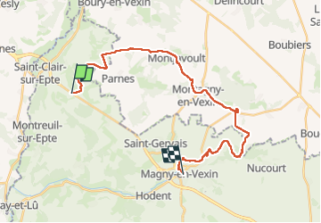
7.8 km | 9.5 km-effort
2h 7min
![](https://static1.geolcdn.com/siteimages/upload/files/16400158638029165_repeat_loop_refresh_sync_direction_icon.png)
Yes
![Trail Walking Château-sur-Epte - Château sur Epte - Rollon Nord - Photo](https://media.geolcdn.com/t/375/260/ext.jpg?maxdim=2&url=https%3A%2F%2Fservices.sitytrail.com%2FGeolivesWS%2FDownloadMedia.ashx%3FTrailID%3D158414%26Media%3Df92478f2-a815-4319-b098-de4877cf6291.jpg)
![Walking Walking](https://static1.geolcdn.com/sitytour/trail-icons/101.png)
Château sur Epte - Rollon Nord
Walking
Easy
(1)
Château-sur-Epte,
Normandy,
Eure,
France
![](/images/other/stat-length.png)
8.4 km | 10.2 km-effort
2h 2min
![](https://static1.geolcdn.com/siteimages/upload/files/16400158638029165_repeat_loop_refresh_sync_direction_icon.png)
Yes
![Trail Walking Boury-en-Vexin - Boury en Vexin - Hérouval - Photo](https://media.geolcdn.com/t/375/260/ext.jpg?maxdim=2&url=https%3A%2F%2Fservices.sitytrail.com%2FGeolivesWS%2FDownloadMedia.ashx%3FTrailID%3D158258%26Media%3D70479d1b-26bd-4332-9afe-06d6c1ec1e96.jpg)
![Walking Walking](https://static1.geolcdn.com/sitytour/trail-icons/101.png)
Boury en Vexin - Hérouval
Walking
Easy
(3)
Boury-en-Vexin,
Hauts-de-France,
Oise,
France
![](/images/other/stat-length.png)
10.9 km | 12.9 km-effort
2h 49min
![](https://static1.geolcdn.com/siteimages/upload/files/16400158638029165_repeat_loop_refresh_sync_direction_icon.png)
Yes
![Trail Walking Vaudancourt - Vaudancourt - Breuil et Boury - Photo](https://media.geolcdn.com/t/375/260/ext.jpg?maxdim=2&url=https%3A%2F%2Fservices.sitytrail.com%2FGeolivesWS%2FDownloadMedia.ashx%3FTrailID%3D157619%26Media%3D1550d1cf-9f43-43fc-88a1-2fb31ebab517.jpg)
![Walking Walking](https://static1.geolcdn.com/sitytour/trail-icons/101.png)
Vaudancourt - Breuil et Boury
Walking
Easy
(1)
Vaudancourt,
Hauts-de-France,
Oise,
France
![](/images/other/stat-length.png)
11.8 km | 14.3 km-effort
3h 5min
![](https://static1.geolcdn.com/siteimages/upload/files/16400158638029165_repeat_loop_refresh_sync_direction_icon.png)
Yes
![Trail Walking Vexin-sur-Epte - Château sur Epte variante par pierre tournante - Photo](https://media.geolcdn.com/t/375/260/ext.jpg?maxdim=2&url=https%3A%2F%2Fstatic1.geolcdn.com%2Fsiteimages%2Fupload%2Ffiles%2F1553511878bg_sport_marche.png)
![Walking Walking](https://static1.geolcdn.com/sitytour/trail-icons/101.png)
Château sur Epte variante par pierre tournante
Walking
Easy
(1)
Vexin-sur-Epte,
Normandy,
Eure,
France
![](/images/other/stat-length.png)
9.8 km | 12.1 km-effort
2h 30min
![](https://static1.geolcdn.com/siteimages/upload/files/16400158638029165_repeat_loop_refresh_sync_direction_icon.png)
Yes
![Trail Nordic walking Boury-en-Vexin - Marche Nordique 75 Boury en Vexin - Photo](https://media.geolcdn.com/t/375/260/ext.jpg?maxdim=2&url=https%3A%2F%2Fstatic1.geolcdn.com%2Fsiteimages%2Fupload%2Ffiles%2F1545311037marcheuse_200dpi.jpg)
![Nordic walking Nordic walking](https://static1.geolcdn.com/sitytour/trail-icons/102.png)
Marche Nordique 75 Boury en Vexin
Nordic walking
Easy
(1)
Boury-en-Vexin,
Hauts-de-France,
Oise,
France
![](/images/other/stat-length.png)
10.3 km | 12.6 km-effort
1h 30min
![](https://static1.geolcdn.com/siteimages/upload/files/16400158638029165_repeat_loop_refresh_sync_direction_icon.png)
Yes
![Trail Nordic walking Authevernes - MN 57 Authevernes - Photo](https://media.geolcdn.com/t/375/260/ext.jpg?maxdim=2&url=https%3A%2F%2Fstatic1.geolcdn.com%2Fsiteimages%2Fupload%2Ffiles%2F1545311037marcheuse_200dpi.jpg)
![Nordic walking Nordic walking](https://static1.geolcdn.com/sitytour/trail-icons/102.png)
MN 57 Authevernes
Nordic walking
Easy
(3)
Authevernes,
Normandy,
Eure,
France
![](/images/other/stat-length.png)
8.5 km | 10.1 km-effort
1h 30min
![](https://static1.geolcdn.com/siteimages/upload/files/16400158638029165_repeat_loop_refresh_sync_direction_icon.png)
Yes
![Trail Walking La Chapelle-en-Vexin - la chapelle en vexin - Photo](https://media.geolcdn.com/t/375/260/ext.jpg?maxdim=2&url=https%3A%2F%2Fstatic1.geolcdn.com%2Fsiteimages%2Fupload%2Ffiles%2F1553511878bg_sport_marche.png)
![Walking Walking](https://static1.geolcdn.com/sitytour/trail-icons/101.png)
la chapelle en vexin
Walking
Medium
(1)
La Chapelle-en-Vexin,
Ile-de-France,
Val-d'Oise,
France
![](/images/other/stat-length.png)
13.9 km | 16.9 km-effort
3h 35min
![](https://static1.geolcdn.com/siteimages/upload/files/16400158638029165_repeat_loop_refresh_sync_direction_icon.png)
Yes
![Trail Walking Guerny - Gisancourt - Notre Dame du Chêne - Photo](https://media.geolcdn.com/t/375/260/ext.jpg?maxdim=2&url=https%3A%2F%2Fstatic1.geolcdn.com%2Fsiteimages%2Fupload%2Ffiles%2F1553511878bg_sport_marche.png)
![Walking Walking](https://static1.geolcdn.com/sitytour/trail-icons/101.png)
Gisancourt - Notre Dame du Chêne
Walking
Easy
(2)
Guerny,
Normandy,
Eure,
France
![](/images/other/stat-length.png)
11.6 km | 13.9 km-effort
3h 2min
![](https://static1.geolcdn.com/siteimages/upload/files/16400158638029165_repeat_loop_refresh_sync_direction_icon.png)
Yes