![](/images/other/stat-length.png)
![Trail Walking Marcillat-en-Combraille - L'Économique - Photo](https://media.geolcdn.com/t/1900/400/ext.pjpeg?maxdim=2&url=https%3A%2F%2Fstatic1.geolcdn.com%2Fsiteimages%2Fupload%2Ffiles%2F1553511878bg_sport_marche.png)
L'Économique
fanthou
User
![Length](/images/other/stat-length.png)
Length
12 km
![Max alt](https://static1.geolcdn.com/siteimages/upload/files/1508320355ic_sort_altitude_max_24dp.png)
Max alt
506 m
![Uphill gradient](https://static1.geolcdn.com/siteimages/upload/files/1508320355ic_sort_den_pos_24dp.png)
Uphill gradient
174 m
![Km-Effort](/images/other/stat-length.png)
Km-Effort
14.3 km
![Min alt](https://static1.geolcdn.com/siteimages/upload/files/1508320355ic_sort_altitude_min_24dp.png)
Min alt
445 m
![Downhill gradient](https://static1.geolcdn.com/siteimages/upload/files/1508320355ic_sort_den_neg_24dp.png)
Downhill gradient
174 m
![Boucle](https://static1.geolcdn.com/siteimages/upload/files/16400158638029165_repeat_loop_refresh_sync_direction_icon.png)
Boucle
Yes
Creation date :
2024-11-29 18:39:29.966
Updated on :
2024-11-29 18:40:20.841
![Walking](https://static1.geolcdn.com/sitytour/trail-icons/101.png)
3h15
Difficulty : Difficult
![Scan this QR Code to open this trail in the SityTrail application](https://capi.geolives.com/qq0zvz2zws4bq2lad0pu/sitytour/trails/4284103/qr.png?size=200)
FREE GPS app for hiking
About
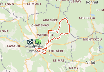
Trail Walking of 12 km to be discovered at Auvergne-Rhône-Alpes, Allier, Marcillat-en-Combraille. This trail is proposed by fanthou.
Description
Remontez le temps en empruntant l'ancienne voie de chemin de fer économique.Cheminez sur la ligne où le tacot passait jadis, entre prairies et élevages de vaches charolaises et limousines.
Positioning
Country:
France
Region :
Auvergne-Rhône-Alpes
Department/Province :
Allier
Municipality :
Marcillat-en-Combraille
Location:
Unknown
Start:(Dec)
Start:(UTM)
471518 ; 5112685 (31T) N.
Comments
Trails nearby
![Trail Mountain bike Saint-Fargeol - Le moulin rouge - Photo](https://media.geolcdn.com/t/375/260/de9828df-3c3a-48d7-b5cf-82bde7aa66d6.jpg&format=jpg&maxdim=2)
![Mountain bike Mountain bike](https://static1.geolcdn.com/sitytour/trail-icons/202.png)
Le moulin rouge
Mountain bike
Difficult
Saint-Fargeol,
Auvergne-Rhône-Alpes,
Allier,
France
![](/images/other/stat-length.png)
30 km | 38 km-effort
2h 39min
![](https://static1.geolcdn.com/siteimages/upload/files/16400158638029165_repeat_loop_refresh_sync_direction_icon.png)
Yes
![Trail Mountain bike Saint-Fargeol - St fargeol - Photo](https://media.geolcdn.com/t/375/260/ext.jpg?maxdim=2&url=https%3A%2F%2Fservices.sitytrail.com%2FGeolivesWS%2FDownloadMedia.ashx%3FTrailID%3D240508%26Media%3Dfix__20140105155324.jpg)
![Mountain bike Mountain bike](https://static1.geolcdn.com/sitytour/trail-icons/202.png)
St fargeol
Mountain bike
Difficult
Saint-Fargeol,
Auvergne-Rhône-Alpes,
Allier,
France
![](/images/other/stat-length.png)
27 km | 35 km-effort
3h 17min
![](https://static1.geolcdn.com/siteimages/upload/files/16400158638029165_repeat_loop_refresh_sync_direction_icon.png)
Yes
![Trail Moto cross Marcillat-en-Combraille - Marcillat - Eveau les Bain - Rochebut - Marcillat - Photo](https://media.geolcdn.com/t/375/260/ext.jpg?maxdim=2&url=https%3A%2F%2Fstatic1.geolcdn.com%2Fsiteimages%2Fupload%2Ffiles%2F1524743155moto.jpg)
![Moto cross Moto cross](https://static1.geolcdn.com/sitytour/trail-icons/406.png)
Marcillat - Eveau les Bain - Rochebut - Marcillat
Moto cross
Medium
(1)
Marcillat-en-Combraille,
Auvergne-Rhône-Alpes,
Allier,
France
![](/images/other/stat-length.png)
54 km | 72 km-effort
Unknown
![](https://static1.geolcdn.com/siteimages/upload/files/16400158638029165_repeat_loop_refresh_sync_direction_icon.png)
Yes
![Trail sport Saint-Marcel-en-Marcillat - Les mares et les murets - Photo](https://media.geolcdn.com/t/375/260/ext.jpg?maxdim=2&url=https%3A%2F%2Fsecurestorage.geolives.com%2Fsitytour%2Ftrail-bg%2Fdefault.jpg)
Les mares et les murets
sport
Very easy
Saint-Marcel-en-Marcillat,
Auvergne-Rhône-Alpes,
Allier,
France
![](/images/other/stat-length.png)
14.2 km | 0 m-effort
Unknown
![](https://static1.geolcdn.com/siteimages/upload/files/16400158638029165_repeat_loop_refresh_sync_direction_icon.png)
Yes
![Trail Walking Marcillat-en-Combraille - Les Tartasses - Photo](https://media.geolcdn.com/t/375/260/ext.jpg?maxdim=2&url=https%3A%2F%2Fstatic1.geolcdn.com%2Fsiteimages%2Fupload%2Ffiles%2F1553511878bg_sport_marche.png)
![Walking Walking](https://static1.geolcdn.com/sitytour/trail-icons/101.png)
Les Tartasses
Walking
Very difficult
Marcillat-en-Combraille,
Auvergne-Rhône-Alpes,
Allier,
France
![](/images/other/stat-length.png)
22 km | 31 km-effort
6h 56min
![](https://static1.geolcdn.com/siteimages/upload/files/16400158638029165_repeat_loop_refresh_sync_direction_icon.png)
Yes
![Trail Walking Marcillat-en-Combraille - Les Tartasses Bis - Photo](https://media.geolcdn.com/t/375/260/ext.jpg?maxdim=2&url=https%3A%2F%2Fstatic1.geolcdn.com%2Fsiteimages%2Fupload%2Ffiles%2F1553511878bg_sport_marche.png)
![Walking Walking](https://static1.geolcdn.com/sitytour/trail-icons/101.png)
Les Tartasses Bis
Walking
Difficult
Marcillat-en-Combraille,
Auvergne-Rhône-Alpes,
Allier,
France
![](/images/other/stat-length.png)
9.4 km | 12.8 km-effort
2h 54min
![](https://static1.geolcdn.com/siteimages/upload/files/16400158638029165_repeat_loop_refresh_sync_direction_icon.png)
Yes
![Trail Walking La Petite-Marche - La randonnée de la Marche - Photo](https://media.geolcdn.com/t/375/260/ext.jpg?maxdim=2&url=https%3A%2F%2Fstatic1.geolcdn.com%2Fsiteimages%2Fupload%2Ffiles%2F1553511878bg_sport_marche.png)
![Walking Walking](https://static1.geolcdn.com/sitytour/trail-icons/101.png)
La randonnée de la Marche
Walking
Medium
La Petite-Marche,
Auvergne-Rhône-Alpes,
Allier,
France
![](/images/other/stat-length.png)
9.4 km | 10.9 km-effort
2h 28min
![](https://static1.geolcdn.com/siteimages/upload/files/16400158638029165_repeat_loop_refresh_sync_direction_icon.png)
Yes
![Trail Walking Saint-Fargeol - Le dolmen de Mazérat Bis - Photo](https://media.geolcdn.com/t/375/260/ext.jpg?maxdim=2&url=https%3A%2F%2Fstatic1.geolcdn.com%2Fsiteimages%2Fupload%2Ffiles%2F1553511878bg_sport_marche.png)
![Walking Walking](https://static1.geolcdn.com/sitytour/trail-icons/101.png)
Le dolmen de Mazérat Bis
Walking
Medium
Saint-Fargeol,
Auvergne-Rhône-Alpes,
Allier,
France
![](/images/other/stat-length.png)
9.1 km | 11.3 km-effort
2h 34min
![](https://static1.geolcdn.com/siteimages/upload/files/16400158638029165_repeat_loop_refresh_sync_direction_icon.png)
Yes
![Trail Walking Marcillat-en-Combraille - Terjat - Photo](https://media.geolcdn.com/t/375/260/ext.jpg?maxdim=2&url=https%3A%2F%2Fstatic1.geolcdn.com%2Fsiteimages%2Fupload%2Ffiles%2F1553511878bg_sport_marche.png)
![Walking Walking](https://static1.geolcdn.com/sitytour/trail-icons/101.png)
Terjat
Walking
Difficult
Marcillat-en-Combraille,
Auvergne-Rhône-Alpes,
Allier,
France
![](/images/other/stat-length.png)
15 km | 18.2 km-effort
3h 9min
![](https://static1.geolcdn.com/siteimages/upload/files/16400158638029165_repeat_loop_refresh_sync_direction_icon.png)
Yes