Trail Walking Sourribes - les balcons du Vançon  - Photo
© OpenStreetMap contributors
Length
Length
24 km
Max alt
Max alt
878 m
Uphill gradient
Uphill gradient
573 m
Km-Effort
Km-Effort  
31 km
Min alt
Min alt
444 m
Downhill gradient
Downhill gradient
607 m
Boucle
Boucle
No
Creation date :
2024-11-25 08:50:38.671
Updated on :
2024-11-25 15:46:49.245

(0 Reviews)

Walking
Walking
5h00
Difficulty : Medium

Scan this QR Code to open this trail in the SityTrail application

FREE GPS app for hiking

Logo SityTrail SityTrail

IGN / Geographical institutes

Download SityTrail from the App Store Download SityTrail from Google Play

Logo SityTrail SityTrail World

The world is yours!

Download SityTrail from the App Store Download SityTrail from Google Play Download SityTrail on Huawei AppGallery

About

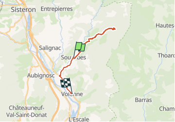
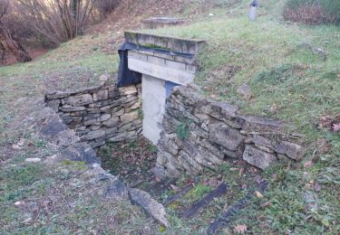
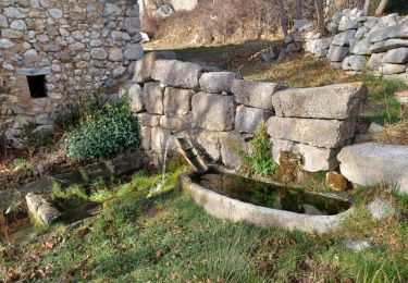
Trail Walking of 24 km to be discovered at Provence-Alpes-Côte d'Azur, Alpes-de-Haute-Provence, Sourribes. This trail is proposed by Montfort .

Description

Randonnée du lundi : 18 participants - 16km, 520 m den. 5h

Elevation profile

Positioning

Country:
France
Region :
Provence-Alpes-Côte d'Azur
Department/Province :
Alpes-de-Haute-Provence
Municipality :
Sourribes
Location:
Unknown
Start:(UTM)
261310 ; 4892577 (32T) N.

Trails nearby

Trail Walking Aubignosc - AUBIGNOSC.  Vieil Chateau Neuf  , canyons o l m s - Photo
Walking
GUIDE
RobinMicheline

Walking

Easy
(1)
Aubignosc, Provence-Alpes-Côte d'Azur, Alpes-de-Haute-Provence, France
12.6 km | 17.6 km-effort
3h 33min
Yes
Trail Walking Aubignosc - AUBIGNOSC . LE PETIT COLORADO . O L S - Photo
Walking
GUIDE
RobinMicheline

Walking

Medium
(1)
Aubignosc, Provence-Alpes-Côte d'Azur, Alpes-de-Haute-Provence, France
8.3 km | 11.3 km-effort
2h 36min
Yes
Trail Walking Peipin - PEIPIN . aubignosc. Le vieux village Château Neuf Val Saint Donnât par GR7  o  53D - Photo
Walking
GUIDE
RobinMicheline

Walking

Easy
(1)
Peipin, Provence-Alpes-Côte d'Azur, Alpes-de-Haute-Provence, France
13.5 km | 18.3 km-effort
3h 44min
Yes
Trail Running Volonne - les 2 sommets sr Jean et tigne - Photo
Running
Bruno.r

Running

Medium
(1)
Volonne, Provence-Alpes-Côte d'Azur, Alpes-de-Haute-Provence, France
10.4 km | 16.2 km-effort
1h 7min
Yes
Trail Walking Volonne - SALIGNAC . CRETES S MARTIN  . CHAPELLES . O L S - Photo
Walking
GUIDE
RobinMicheline

Walking

Medium
Volonne, Provence-Alpes-Côte d'Azur, Alpes-de-Haute-Provence, France
12.9 km | 19.2 km-effort
3h 32min
Yes
Trail Walking Peipin - CORBIERRES . LE TROU DU LOUP o s - Photo
Walking
GUIDE
RobinMicheline

Walking

Medium
Peipin, Provence-Alpes-Côte d'Azur, Alpes-de-Haute-Provence, France
59 km | 91 km-effort
3h 29min
No
Trail Walking Volonne - VOLONNE . AU FIL DE L EAU N - Photo
Walking
GUIDE
RobinMicheline

Walking

Medium
Volonne, Provence-Alpes-Côte d'Azur, Alpes-de-Haute-Provence, France
6.3 km | 8.4 km-effort
2h 5min
Yes
Trail Walking Entrepierres - VILHOSC MONTAGNE S MICHEL .CHAPELLE S PIERRE . NAUX O L  - Photo
Walking
GUIDE
RobinMicheline

Walking

Medium
Entrepierres, Provence-Alpes-Côte d'Azur, Alpes-de-Haute-Provence, France
13.9 km | 23 km-effort
4h 33min
Yes
Trail Walking Aubignosc - AUBIGNOSC . LES CRÊTES.  LE PAS DES BOEUFS  .O L - Photo
Walking
GUIDE
RobinMicheline

Walking

Medium
Aubignosc, Provence-Alpes-Côte d'Azur, Alpes-de-Haute-Provence, France
7.3 km | 10.1 km-effort
2h 4min
Yes


Close
My subscriptions