![](/images/other/stat-length.png)
![Trail Walking Prunet-et-Belpuig - BOULE d'AMONT - La TRINITE - Photo](https://media.geolcdn.com/t/1900/400/63148342-eaf9-42f9-af5b-21ab9e845710.jpg&format=pjpeg&maxdim=2)
BOULE d'AMONT - La TRINITE
MarcOBRECHT
User
![Length](/images/other/stat-length.png)
Length
12.4 km
![Max alt](https://static1.geolcdn.com/siteimages/upload/files/1508320355ic_sort_altitude_max_24dp.png)
Max alt
686 m
![Uphill gradient](https://static1.geolcdn.com/siteimages/upload/files/1508320355ic_sort_den_pos_24dp.png)
Uphill gradient
348 m
![Km-Effort](/images/other/stat-length.png)
Km-Effort
17 km
![Min alt](https://static1.geolcdn.com/siteimages/upload/files/1508320355ic_sort_altitude_min_24dp.png)
Min alt
408 m
![Downhill gradient](https://static1.geolcdn.com/siteimages/upload/files/1508320355ic_sort_den_neg_24dp.png)
Downhill gradient
349 m
![Boucle](https://static1.geolcdn.com/siteimages/upload/files/16400158638029165_repeat_loop_refresh_sync_direction_icon.png)
Boucle
Yes
Creation date :
2024-11-21 09:19:37.689
Updated on :
2024-11-23 22:04:10.391
![Walking](https://static1.geolcdn.com/sitytour/trail-icons/101.png)
3h20
Difficulty : Medium
![Scan this QR Code to open this trail in the SityTrail application](https://capi.geolives.com/qq0zvz2zws4bq2lad0pu/sitytour/trails/4276879/qr.png?size=200)
FREE GPS app for hiking
About
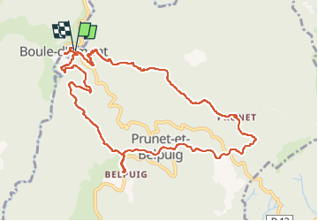
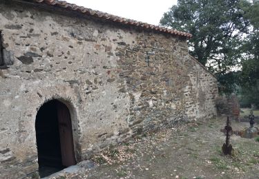
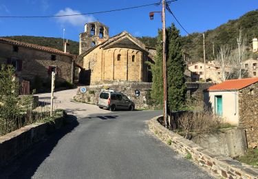
Trail Walking of 12.4 km to be discovered at Occitania, Pyrénées-Orientales, Prunet-et-Belpuig. This trail is proposed by MarcOBRECHT.
Description
Depuis boule d'amont en montant vers la chapelle de Prunet.
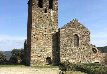
Direction la Trinité puis montée aux ruines du chateau et visite de l'église.
Descente et retour
Positioning
Country:
France
Region :
Occitania
Department/Province :
Pyrénées-Orientales
Municipality :
Prunet-et-Belpuig
Location:
Unknown
Start:(Dec)
Start:(UTM)
468496 ; 4714212 (31T) N.
Comments
Trails nearby
![Trail Walking Casefabre - Casefabre 66 - Photo](https://media.geolcdn.com/t/375/260/fda5b463-42b5-4e8b-9ebd-458b38a5ec57.jpg&format=jpg&maxdim=2)
![Walking Walking](https://static1.geolcdn.com/sitytour/trail-icons/101.png)
Casefabre 66
Walking
Medium
Casefabre,
Occitania,
Pyrénées-Orientales,
France
![](/images/other/stat-length.png)
10.4 km | 14.8 km-effort
3h 19min
![](https://static1.geolcdn.com/siteimages/upload/files/16400158638029165_repeat_loop_refresh_sync_direction_icon.png)
Yes
![Trail Walking Prunet-et-Belpuig - Boule d’amont /Chapelle de la Trinité / Prunet - Photo](https://media.geolcdn.com/t/375/260/68eed7a9-ae13-40d7-8c91-a7b1707b93bf.jpg&format=jpg&maxdim=2)
![Walking Walking](https://static1.geolcdn.com/sitytour/trail-icons/101.png)
Boule d’amont /Chapelle de la Trinité / Prunet
Walking
Easy
Prunet-et-Belpuig,
Occitania,
Pyrénées-Orientales,
France
![](/images/other/stat-length.png)
11.2 km | 16 km-effort
3h 6min
![](https://static1.geolcdn.com/siteimages/upload/files/16400158638029165_repeat_loop_refresh_sync_direction_icon.png)
Yes
![Trail Walking Boule-d'Amont - 20240104 Tour depuis le prieuré de Serrabonne - Photo](https://media.geolcdn.com/t/375/260/a082747f-89ab-4e46-8caf-fd728589230f.jpg&format=jpg&maxdim=2)
![Walking Walking](https://static1.geolcdn.com/sitytour/trail-icons/101.png)
20240104 Tour depuis le prieuré de Serrabonne
Walking
Medium
Boule-d'Amont,
Occitania,
Pyrénées-Orientales,
France
![](/images/other/stat-length.png)
15.2 km | 26 km-effort
4h 37min
![](https://static1.geolcdn.com/siteimages/upload/files/16400158638029165_repeat_loop_refresh_sync_direction_icon.png)
Yes
![Trail Walking Boule-d'Amont - Serrabone /le roc rouge(le rocher du dragon):itinéraire 2 - Photo](https://media.geolcdn.com/t/375/260/26b43676-9e75-4b0d-befc-d44645d8fbe1.jpg&format=jpg&maxdim=2)
![Walking Walking](https://static1.geolcdn.com/sitytour/trail-icons/101.png)
Serrabone /le roc rouge(le rocher du dragon):itinéraire 2
Walking
Medium
Boule-d'Amont,
Occitania,
Pyrénées-Orientales,
France
![](/images/other/stat-length.png)
10.1 km | 17.5 km-effort
3h 32min
![](https://static1.geolcdn.com/siteimages/upload/files/16400158638029165_repeat_loop_refresh_sync_direction_icon.png)
Yes
![Trail Walking Boule-d'Amont - Serra une - Photo](https://media.geolcdn.com/t/375/260/40936afc-9b58-415d-9be4-e3356895329e.jpg&format=jpg&maxdim=2)
![Walking Walking](https://static1.geolcdn.com/sitytour/trail-icons/101.png)
Serra une
Walking
Medium
Boule-d'Amont,
Occitania,
Pyrénées-Orientales,
France
![](/images/other/stat-length.png)
10.4 km | 17.8 km-effort
3h 44min
![](https://static1.geolcdn.com/siteimages/upload/files/16400158638029165_repeat_loop_refresh_sync_direction_icon.png)
Yes
![Trail Walking Boule-d'Amont - 20210321 Boule d’Amont - Serrabone - Photo](https://media.geolcdn.com/t/375/260/16b44598-e6b8-4fe8-87e4-5112a1cd140b.jpg&format=jpg&maxdim=2)
![Walking Walking](https://static1.geolcdn.com/sitytour/trail-icons/101.png)
20210321 Boule d’Amont - Serrabone
Walking
Medium
Boule-d'Amont,
Occitania,
Pyrénées-Orientales,
France
![](/images/other/stat-length.png)
13.4 km | 23 km-effort
3h 58min
![](https://static1.geolcdn.com/siteimages/upload/files/16400158638029165_repeat_loop_refresh_sync_direction_icon.png)
Yes
![Trail Walking Boule-d'Amont - Serrabonne autour du prieuré - Photo](https://media.geolcdn.com/t/375/260/24231eed-2f48-4061-8c52-7dd0f6f55a72.jpg&format=jpg&maxdim=2)
![Walking Walking](https://static1.geolcdn.com/sitytour/trail-icons/101.png)
Serrabonne autour du prieuré
Walking
Medium
Boule-d'Amont,
Occitania,
Pyrénées-Orientales,
France
![](/images/other/stat-length.png)
9.3 km | 16.2 km-effort
4h 27min
![](https://static1.geolcdn.com/siteimages/upload/files/16400158638029165_repeat_loop_refresh_sync_direction_icon.png)
Yes
![Trail Walking Caixas - Fontcouverte 3 chapelles - Photo](https://media.geolcdn.com/t/375/260/af49db35-9ffa-47e6-b836-be8e544cfc79.jpg&format=jpg&maxdim=2)
![Walking Walking](https://static1.geolcdn.com/sitytour/trail-icons/101.png)
Fontcouverte 3 chapelles
Walking
Difficult
Caixas,
Occitania,
Pyrénées-Orientales,
France
![](/images/other/stat-length.png)
28 km | 38 km-effort
3h 46min
![](https://static1.geolcdn.com/siteimages/upload/files/16400158638029165_repeat_loop_refresh_sync_direction_icon.png)
No
![Trail Walking Prunet-et-Belpuig - Boule d’amont Prunet-et-Belpuig la Trinité - Photo](https://media.geolcdn.com/t/375/260/a989c071-b899-4092-a76b-68c708add189.jpg&format=jpg&maxdim=2)
![Walking Walking](https://static1.geolcdn.com/sitytour/trail-icons/101.png)
Boule d’amont Prunet-et-Belpuig la Trinité
Walking
Difficult
Prunet-et-Belpuig,
Occitania,
Pyrénées-Orientales,
France
![](/images/other/stat-length.png)
13.7 km | 19.4 km-effort
3h 25min
![](https://static1.geolcdn.com/siteimages/upload/files/16400158638029165_repeat_loop_refresh_sync_direction_icon.png)
Yes