![](/images/other/stat-length.png)
![Trail Walking Saint-Gély-du-Fesc - Jardins du Puech de Fourques - Photo](https://media.geolcdn.com/t/1900/400/ext.pjpeg?maxdim=2&url=https%3A%2F%2Fstatic1.geolcdn.com%2Fsiteimages%2Fupload%2Ffiles%2F1553511878bg_sport_marche.png)
Jardins du Puech de Fourques
Fifi3459
User
![Length](/images/other/stat-length.png)
Length
1.2 km
![Max alt](https://static1.geolcdn.com/siteimages/upload/files/1508320355ic_sort_altitude_max_24dp.png)
Max alt
107 m
![Uphill gradient](https://static1.geolcdn.com/siteimages/upload/files/1508320355ic_sort_den_pos_24dp.png)
Uphill gradient
21 m
![Km-Effort](/images/other/stat-length.png)
Km-Effort
1.4 km
![Min alt](https://static1.geolcdn.com/siteimages/upload/files/1508320355ic_sort_altitude_min_24dp.png)
Min alt
86 m
![Downhill gradient](https://static1.geolcdn.com/siteimages/upload/files/1508320355ic_sort_den_neg_24dp.png)
Downhill gradient
4 m
![Boucle](https://static1.geolcdn.com/siteimages/upload/files/16400158638029165_repeat_loop_refresh_sync_direction_icon.png)
Boucle
No
Creation date :
2024-11-19 09:29:11.0
Updated on :
2024-11-19 09:29:12.885
![Walking](https://static1.geolcdn.com/sitytour/trail-icons/101.png)
19m
Difficulty : Easy
![Scan this QR Code to open this trail in the SityTrail application](https://capi.geolives.com/qq0zvz2zws4bq2lad0pu/sitytour/trails/4274963/qr.png?size=200)
FREE GPS app for hiking
About
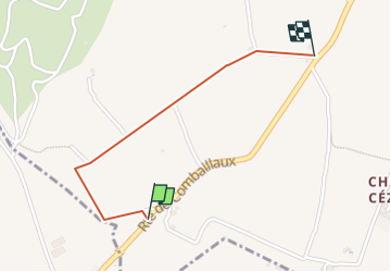
Trail Walking of 1.2 km to be discovered at Occitania, Hérault, Saint-Gély-du-Fesc. This trail is proposed by Fifi3459.
Description
Depart ouvert dans champ, longer les jardins puis le ruisseau, remonter a droite , prendre le chemin en face ( croisement), tout drout jusqu’au mazet (a gauche), prendre a droite , fin au bout , a la maison , se positionner a droite
Positioning
Country:
France
Region :
Occitania
Department/Province :
Hérault
Municipality :
Saint-Gély-du-Fesc
Location:
Unknown
Start:(Dec)
Start:(UTM)
563637 ; 4836593 (31T) N.
Comments
Trails nearby
![Trail Walking Grabels - Source de l'Avy et tour de Grabels 17.12.23 - Photo](https://media.geolcdn.com/t/375/260/f5395191-c7db-4fbb-a0d5-1ea84961d0f4.jpg&format=jpg&maxdim=2)
![Walking Walking](https://static1.geolcdn.com/sitytour/trail-icons/101.png)
Source de l'Avy et tour de Grabels 17.12.23
Walking
Easy
Grabels,
Occitania,
Hérault,
France
![](/images/other/stat-length.png)
11.4 km | 14.3 km-effort
3h 0min
![](https://static1.geolcdn.com/siteimages/upload/files/16400158638029165_repeat_loop_refresh_sync_direction_icon.png)
Yes
![Trail Walking Grabels - Grabels (source de l'Avy, goule de Laval) - Photo](https://media.geolcdn.com/t/375/260/ext.jpg?maxdim=2&url=https%3A%2F%2Fstatic1.geolcdn.com%2Fsiteimages%2Fupload%2Ffiles%2F1553511878bg_sport_marche.png)
![Walking Walking](https://static1.geolcdn.com/sitytour/trail-icons/101.png)
Grabels (source de l'Avy, goule de Laval)
Walking
Easy
(1)
Grabels,
Occitania,
Hérault,
France
![](/images/other/stat-length.png)
10.7 km | 13.2 km-effort
2h 35min
![](https://static1.geolcdn.com/siteimages/upload/files/16400158638029165_repeat_loop_refresh_sync_direction_icon.png)
Yes
![Trail Walking Vailhauquès - belair grabels - Photo](https://media.geolcdn.com/t/375/260/ext.jpg?maxdim=2&url=https%3A%2F%2Fstatic1.geolcdn.com%2Fsiteimages%2Fupload%2Ffiles%2F1553511878bg_sport_marche.png)
![Walking Walking](https://static1.geolcdn.com/sitytour/trail-icons/101.png)
belair grabels
Walking
Very easy
(1)
Vailhauquès,
Occitania,
Hérault,
France
![](/images/other/stat-length.png)
7.9 km | 9.5 km-effort
1h 29min
![](https://static1.geolcdn.com/siteimages/upload/files/16400158638029165_repeat_loop_refresh_sync_direction_icon.png)
Yes
![Trail Walking Murles - la garrigue de Murles - Photo](https://media.geolcdn.com/t/375/260/ext.jpg?maxdim=2&url=https%3A%2F%2Fstatic1.geolcdn.com%2Fsiteimages%2Fupload%2Ffiles%2F1553511878bg_sport_marche.png)
![Walking Walking](https://static1.geolcdn.com/sitytour/trail-icons/101.png)
la garrigue de Murles
Walking
Easy
(2)
Murles,
Occitania,
Hérault,
France
![](/images/other/stat-length.png)
11.2 km | 14.5 km-effort
2h 51min
![](https://static1.geolcdn.com/siteimages/upload/files/16400158638029165_repeat_loop_refresh_sync_direction_icon.png)
Yes
![Trail Walking Saint-Clément-de-Rivière - St Clément de Rivière - Photo](https://media.geolcdn.com/t/375/260/6bac307b-05ff-413e-9484-31e9807bb3da.jpg&format=jpg&maxdim=2)
![Walking Walking](https://static1.geolcdn.com/sitytour/trail-icons/101.png)
St Clément de Rivière
Walking
Medium
Saint-Clément-de-Rivière,
Occitania,
Hérault,
France
![](/images/other/stat-length.png)
9 km | 11 km-effort
2h 2min
![](https://static1.geolcdn.com/siteimages/upload/files/16400158638029165_repeat_loop_refresh_sync_direction_icon.png)
Yes
![Trail Walking Saint-Clément-de-Rivière - convalescence - Photo](https://media.geolcdn.com/t/375/260/12b1ad0b-f88b-4062-94ec-cfe334dabefe.jpg&format=jpg&maxdim=2)
![Walking Walking](https://static1.geolcdn.com/sitytour/trail-icons/101.png)
convalescence
Walking
Medium
Saint-Clément-de-Rivière,
Occitania,
Hérault,
France
![](/images/other/stat-length.png)
8.2 km | 9.6 km-effort
2h 15min
![](https://static1.geolcdn.com/siteimages/upload/files/16400158638029165_repeat_loop_refresh_sync_direction_icon.png)
Yes
![Trail Walking Grabels - serre grenouillet - Photo](https://media.geolcdn.com/t/375/260/79544ed1-7b3f-4215-a23e-46411ce5a4fb.jpg&format=jpg&maxdim=2)
![Walking Walking](https://static1.geolcdn.com/sitytour/trail-icons/101.png)
serre grenouillet
Walking
Difficult
Grabels,
Occitania,
Hérault,
France
![](/images/other/stat-length.png)
10.6 km | 12.3 km-effort
4h 38min
![](https://static1.geolcdn.com/siteimages/upload/files/16400158638029165_repeat_loop_refresh_sync_direction_icon.png)
No
![Trail Walking Murles - Sensei2021 - Photo](https://media.geolcdn.com/t/375/260/2361557c-09ee-4bf6-af3f-849bf7b9ba31.jpg&format=jpg&maxdim=2)
![Walking Walking](https://static1.geolcdn.com/sitytour/trail-icons/101.png)
![Trail Walking Murles - autour de murles 34 - Photo](https://media.geolcdn.com/t/375/260/cea761f6-20ec-43ef-938a-2f599b0e32ed.jpg&format=jpg&maxdim=2)
![Walking Walking](https://static1.geolcdn.com/sitytour/trail-icons/101.png)
autour de murles 34
Walking
Medium
Murles,
Occitania,
Hérault,
France
![](/images/other/stat-length.png)
15.1 km | 21 km-effort
3h 34min
![](https://static1.geolcdn.com/siteimages/upload/files/16400158638029165_repeat_loop_refresh_sync_direction_icon.png)
Yes