Trail Walking Fontainebleau - M&R-150522 - PVerte-Béatrix-MareFées - Photo

M&R-150522 - PVerte-Béatrix-MareFées

 randodan
randodan

User

© OpenStreetMap contributors
Length
Length
10.8 km
Max alt
Max alt
138 m
Uphill gradient
Uphill gradient
191 m
Km-Effort
Km-Effort  
13.4 km
Min alt
Min alt
92 m
Downhill gradient
Downhill gradient
191 m
Boucle
Boucle
Yes
Creation date :
2015-06-08 00:00:00.0
Updated on :
2015-06-08 00:00:00.0

(0 Reviews)

Walking
Walking
3h50
Difficulty : Easy

Scan this QR Code to open this trail in the SityTrail application

FREE GPS app for hiking

Logo SityTrail SityTrail

IGN / Geographical institutes

Download SityTrail from the App Store Download SityTrail from Google Play

Logo SityTrail SityTrail World

The world is yours!

Download SityTrail from the App Store Download SityTrail from Google Play Download SityTrail on Huawei AppGallery

About

Trail Walking of 10.8 km to be discovered at Ile-de-France, Seine-et-Marne, Fontainebleau. This trail is proposed by randodan.

Description

Béatrix et salades avec Marche et Rêve<br>
- 22 mai 2015 -<br>
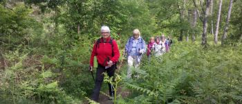
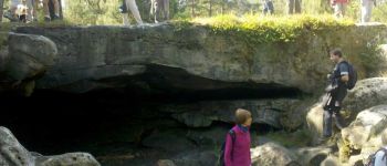
9h40, départ du parking de la Plaine Verte, Jean-Pierre nous emmène sur le Denecourt n°11 (qu'on gardera toute la journée) vers le Restant du Long Rocher (boucle Est) . 10h30 à la Grotte Béatrice . Pour le retour, on rallonge un peu en bouclant par la Route des Etroitures.<br>
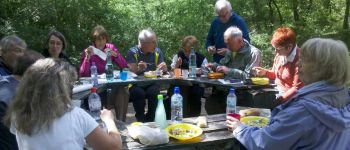
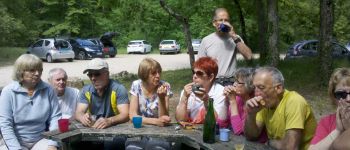
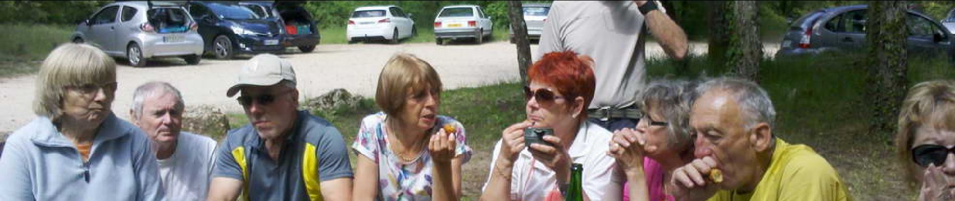
Midi, on installe les tables pour la "salades-party" . Le choix ne manque pas, et on n'arrivera pas à tout manger . Par contre toutes les bouteilles auront été vidées ;o).<br>
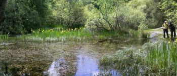
13h40, c'est reparti pour la boucle Ouest sur le Rocher des Etroitures . 14h30, faisons le tour de la Mare aux Fées.<br>
15h10, de retour au parking, et à nouveau à table pour le cidre et les gâteaux.<br>
27 participants le matin, mais 29 à table à midi.

Elevation profile

Photos

Points of interest

Point of interest Fontainebleau - 01 - Une, deux, une, deux..., sur le Denecourt 11 - Photo
randodan
Point of interest Fontainebleau - 02 - Pause à la Grotte Béatrix - Photo
randodan
Point of interest Fontainebleau - 03 - Le pique-nique à la Plaine Verte - Photo
randodan
Point of interest Fontainebleau - 04 - La Mare aux Fées - Photo
randodan
FONTAINEBLEAU 
Point of interest Fontainebleau - 05 - Cidre et gâteaux à la Plaine Verte - Photo
randodan

Positioning

Country:
France
Region :
Ile-de-France
Department/Province :
Seine-et-Marne
Municipality :
Fontainebleau
Location:
Unknown
Start:(UTM)
479837 ; 5355713 (31U) N.

Trails nearby

Trail Walking Fontainebleau - La Mare aux Fées 18km - Forêt de Fontainebleau - Photo
Walking
onftest

Walking

Medium
(5)
Fontainebleau, Ile-de-France, Seine-et-Marne, France
18 km | 22 km-effort
4h 41min
Yes
Trail On foot Fontainebleau - Boucle 28 km en forêt de Fontainebleau  - Photo
On foot
GUIDE
chessyca

On foot

Medium
(1)
Fontainebleau, Ile-de-France, Seine-et-Marne, France
28 km | 34 km-effort
7h 43min
Yes
Trail Walking Fontainebleau - GLM-150311 - PVerte-Fourceau-Béatrix - Photo
Walking
randodan

Walking

Medium
(1)
Fontainebleau, Ile-de-France, Seine-et-Marne, France
16.5 km | 20 km-effort
6h 0min
Yes
Trail Walking Fontainebleau - Boucle 30 km Veni Venelles Vici - Photo
Walking
GUIDE
chessyca

Walking

Very difficult
(1)
Fontainebleau, Ile-de-France, Seine-et-Marne, France
30 km | 35 km-effort
6h 0min
No
Trail Walking Bourron-Marlotte - Boucle Bourron Marlotte ( reco Didier) - Photo
Walking
GUIDE
chessyca

Walking

Easy
(1)
Bourron-Marlotte, Ile-de-France, Seine-et-Marne, France
28 km | 32 km-effort
5h 35min
Yes
Trail Walking Fontainebleau - Rocher Fourceau-Petit Mont Chauvet SR210523Ve?? fmg - Photo
Walking
fmg

Walking

Very difficult
(1)
Fontainebleau, Ile-de-France, Seine-et-Marne, France
19.5 km | 24 km-effort
5h 27min
Yes
Trail Walking Fontainebleau - Rando mares aux fees Gilles18 km - Photo
Walking
GUIDE
jeanmarcMasson

Walking

Very difficult
(1)
Fontainebleau, Ile-de-France, Seine-et-Marne, France
17.8 km | 22 km-effort
4h 58min
Yes
Trail Walking Fontainebleau - viennes carosses - Photo
Walking
Yannick.Boireau

Walking

Very easy
(2)
Fontainebleau, Ile-de-France, Seine-et-Marne, France
10.8 km | 14 km-effort
2h 50min
Yes
Trail On foot Moret-Loing-et-Orvanne - La basse vallée du Lunain version 30 km - Photo
On foot
GUIDE
chessyca

On foot

Difficult
Moret-Loing-et-Orvanne, Ile-de-France, Seine-et-Marne, France
30 km | 34 km-effort
7h 39min
Yes


Close
My subscriptions